Saint-Romain-en-Gal
| Saint-Romain-en-Gal | ||
|---|---|---|
| Commune | ||
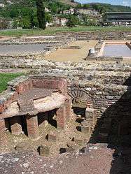 An archaeological site in Saint-Romain-en-Gal | ||
| ||
 Saint-Romain-en-Gal Location within Auvergne-Rhône-Alpes region  Saint-Romain-en-Gal | ||
| Coordinates: 45°31′59″N 4°51′43″E / 45.533°N 4.862°ECoordinates: 45°31′59″N 4°51′43″E / 45.533°N 4.862°E | ||
| Country | France | |
| Region | Auvergne-Rhône-Alpes | |
| Department | Rhône | |
| Arrondissement | Lyon | |
| Canton | Mornant | |
| Intercommunality | Pays Viennois | |
| Government | ||
| • Mayor | Langlais Pierre | |
| Area1 | 13.39 km2 (5.17 sq mi) | |
| Population (2006)2 | 1,701 | |
| • Density | 130/km2 (330/sq mi) | |
| Time zone | UTC+1 (CET) | |
| • Summer (DST) | UTC+2 (CEST) | |
| INSEE/Postal code | 69235 /69560 | |
| Elevation |
140–528 m (459–1,732 ft) (avg. 153 m or 502 ft) | |
|
1 French Land Register data, which excludes lakes, ponds, glaciers > 1 km2 (0.386 sq mi or 247 acres) and river estuaries. 2 Population without double counting: residents of multiple communes (e.g., students and military personnel) only counted once. | ||
.svg.png)
Saint-Romain-en-Gal is a commune in the Rhône department in eastern France.
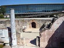
Gallo-Roman museum of Saint-Romain-en-Gal
See also
References
| Wikimedia Commons has media related to Saint-Romain-en-Gal. |
This article is issued from
Wikipedia.
The text is licensed under Creative Commons - Attribution - Sharealike.
Additional terms may apply for the media files.