Bully, Rhône
| Bully | ||
|---|---|---|
| Commune | ||
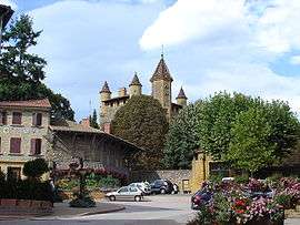 The château, in Bully | ||
| ||
 Bully Location within Auvergne-Rhône-Alpes region  Bully | ||
| Coordinates: 45°51′07″N 4°35′02″E / 45.8519°N 4.5839°ECoordinates: 45°51′07″N 4°35′02″E / 45.8519°N 4.5839°E | ||
| Country | France | |
| Region | Auvergne-Rhône-Alpes | |
| Department | Rhône | |
| Arrondissement | Villefranche-sur-Saône | |
| Canton | Le Bois-d'Oingt | |
| Intercommunality | Pays de l'Arbresle | |
| Government | ||
| • Mayor (2014–2020) | Charles-Henri Bernard | |
| Area1 | 12.59 km2 (4.86 sq mi) | |
| Population (2012)2 | 2,082 | |
| • Density | 170/km2 (430/sq mi) | |
| Time zone | UTC+1 (CET) | |
| • Summer (DST) | UTC+2 (CEST) | |
| INSEE/Postal code | 69032 /69210 | |
| Elevation |
230–437 m (755–1,434 ft) (avg. 313 m or 1,027 ft) | |
|
1 French Land Register data, which excludes lakes, ponds, glaciers > 1 km2 (0.386 sq mi or 247 acres) and river estuaries. 2 Population without double counting: residents of multiple communes (e.g., students and military personnel) only counted once. | ||
.svg.png)
Bully is a commune in the Rhône department in eastern France.
See also
References
| Wikimedia Commons has media related to Bully (Rhône). |
This article is issued from
Wikipedia.
The text is licensed under Creative Commons - Attribution - Sharealike.
Additional terms may apply for the media files.