Chasselay, Rhône
| Chasselay | ||
|---|---|---|
| Commune | ||
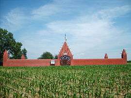 Senegalese Tirailleurs military cemetery in Chasselay | ||
| ||
 Chasselay Location within Auvergne-Rhône-Alpes region  Chasselay | ||
| Coordinates: 45°52′31″N 4°46′23″E / 45.8753°N 4.7731°ECoordinates: 45°52′31″N 4°46′23″E / 45.8753°N 4.7731°E | ||
| Country | France | |
| Region | Auvergne-Rhône-Alpes | |
| Department | Rhône | |
| Arrondissement | Villefranche-sur-Saône | |
| Canton | Anse | |
| Intercommunality | Communauté de communes Beaujolais-Pierres-Dorées | |
| Government | ||
| • Mayor (2014–2020) | Jacques Pariost | |
| Area1 | 12.78 km2 (4.93 sq mi) | |
| Population (2012)2 | 2,687 | |
| • Density | 210/km2 (540/sq mi) | |
| Time zone | UTC+1 (CET) | |
| • Summer (DST) | UTC+2 (CEST) | |
| INSEE/Postal code | 69049 /69380 | |
| Elevation |
189–524 m (620–1,719 ft) (avg. 200 m or 660 ft) | |
|
1 French Land Register data, which excludes lakes, ponds, glaciers > 1 km2 (0.386 sq mi or 247 acres) and river estuaries. 2 Population without double counting: residents of multiple communes (e.g., students and military personnel) only counted once. | ||
.svg.png)
Chasselay is a commune in the Rhône department in eastern France. The village is located between Lyon and Villefranche-sur-Saône. It is a relatively rural community without a train station.
Main sights
Sports
- Monts d'Or Azergues Foot football team based in Chasselay
Notable people
- Guy Lassausaie, chef
See also
References
- ↑ "The Senegalese Tata in Chasselay". www.cheminsdememoire.gouv.fr. Retrieved 2018-10-09.
| Wikimedia Commons has media related to Chasselay, Rhône. |
This article is issued from
Wikipedia.
The text is licensed under Creative Commons - Attribution - Sharealike.
Additional terms may apply for the media files.