Porte des Pierres Dorées
| Porte des Pierres Dorées | |
|---|---|
| Commune | |
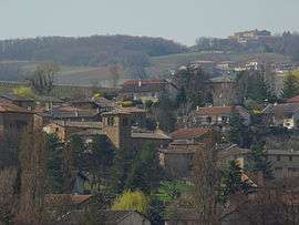 A general view of Pouilly-le-Monial | |
 Porte des Pierres Dorées Location within Auvergne-Rhône-Alpes region  Porte des Pierres Dorées | |
| Coordinates: 45°57′29″N 4°38′49″E / 45.958°N 4.647°ECoordinates: 45°57′29″N 4°38′49″E / 45.958°N 4.647°E | |
| Country | France |
| Region | Auvergne-Rhône-Alpes |
| Department | Rhône |
| Arrondissement | Villefranche-sur-Saône |
| Canton | Le Bois-d'Oingt |
| Intercommunality | Beaujolais-Pierres Dorées |
| Area1 | 9.13 km2 (3.53 sq mi) |
| Population (2014)2 | 2,948 |
| • Density | 320/km2 (840/sq mi) |
| Time zone | UTC+1 (CET) |
| • Summer (DST) | UTC+2 (CEST) |
| INSEE/Postal code | 69159 /69400 |
|
1 French Land Register data, which excludes lakes, ponds, glaciers > 1 km2 (0.386 sq mi or 247 acres) and river estuaries. 2 Population without double counting: residents of multiple communes (e.g., students and military personnel) only counted once. | |
Porte des Pierres Dorées is a commune in the department of Rhône, eastern France. The municipality was established on 1 January 2017 by merger of the former communes of Pouilly-le-Monial (the seat) and Liergues.[1]
See also
References
| Wikimedia Commons has media related to Porte des Pierres Dorées. |
- ↑ Arrêté préfectoral 22 September 2016 (in French)
This article is issued from
Wikipedia.
The text is licensed under Creative Commons - Attribution - Sharealike.
Additional terms may apply for the media files.