Saint-Romain-de-Popey
| Saint-Romain-de-Popey | |
|---|---|
| Commune | |
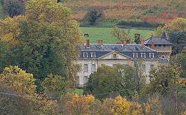 The Château of Avauges, in Saint-Romain-de-Popey | |
 Saint-Romain-de-Popey Location within Auvergne-Rhône-Alpes region  Saint-Romain-de-Popey | |
| Coordinates: 45°50′53″N 4°31′55″E / 45.8481°N 4.5319°ECoordinates: 45°50′53″N 4°31′55″E / 45.8481°N 4.5319°E | |
| Country | France |
| Region | Auvergne-Rhône-Alpes |
| Department | Rhône |
| Arrondissement | Villefranche-sur-Saône |
| Canton | Tarare |
| Government | |
| • Mayor (2008–2014) | Pierre Desbois |
| Area1 | 17.02 km2 (6.57 sq mi) |
| Population (2005)2 | 1,384 |
| • Density | 81/km2 (210/sq mi) |
| Time zone | UTC+1 (CET (GMT +1)) |
| • Summer (DST) | UTC+2 (CEST) |
| INSEE/Postal code | 69234 /69490 |
|
1 French Land Register data, which excludes lakes, ponds, glaciers > 1 km2 (0.386 sq mi or 247 acres) and river estuaries. 2 Population without double counting: residents of multiple communes (e.g., students and military personnel) only counted once. | |
Saint-Romain-de-Popey is a commune in the Rhône department in eastern France.
Sites and Monuments
- Château d'Avauges
- Chapelle de Clévy
See also
References
| Wikimedia Commons has media related to Saint-Romain-de-Popey. |
This article is issued from
Wikipedia.
The text is licensed under Creative Commons - Attribution - Sharealike.
Additional terms may apply for the media files.