Saint-André-la-Côte
| Saint-André-la-Côte | ||
|---|---|---|
| Commune | ||
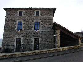 The town hall in Saint-André-la-Côte | ||
| ||
 Saint-André-la-Côte Location within Auvergne-Rhône-Alpes region  Saint-André-la-Côte | ||
| Coordinates: 45°37′52″N 4°36′05″E / 45.6311°N 4.6014°ECoordinates: 45°37′52″N 4°36′05″E / 45.6311°N 4.6014°E | ||
| Country | France | |
| Region | Auvergne-Rhône-Alpes | |
| Department | Rhône | |
| Arrondissement | Lyon | |
| Canton | Vaugneray | |
| Government | ||
| • Mayor (2008–2014) | Jean-Paul Piquet | |
| Area1 | 4.77 km2 (1.84 sq mi) | |
| Population (2007)2 | 268 | |
| • Density | 56/km2 (150/sq mi) | |
| Time zone | UTC+1 (CET) | |
| • Summer (DST) | UTC+2 (CEST) | |
| INSEE/Postal code | 69180 /69440 | |
| Elevation |
640–929 m (2,100–3,048 ft) (avg. 937 m or 3,074 ft) | |
|
1 French Land Register data, which excludes lakes, ponds, glaciers > 1 km2 (0.386 sq mi or 247 acres) and river estuaries. 2 Population without double counting: residents of multiple communes (e.g., students and military personnel) only counted once. | ||
.svg.png)
Saint-André-la-Côte is a commune in the Rhône department in eastern France.
See also
References
| Wikimedia Commons has media related to Saint-André-la-Côte. |
This article is issued from
Wikipedia.
The text is licensed under Creative Commons - Attribution - Sharealike.
Additional terms may apply for the media files.