Montmelas-Saint-Sorlin
| Montmelas-Saint-Sorlin | |
|---|---|
| Commune | |
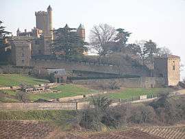 The Château of Montmelas | |
 Montmelas-Saint-Sorlin Location within Auvergne-Rhône-Alpes region  Montmelas-Saint-Sorlin | |
| Coordinates: 46°00′58″N 4°36′38″E / 46.0161°N 4.6106°ECoordinates: 46°00′58″N 4°36′38″E / 46.0161°N 4.6106°E | |
| Country | France |
| Region | Auvergne-Rhône-Alpes |
| Department | Rhône |
| Arrondissement | Villefranche-sur-Saône |
| Canton | Gleizé |
| Government | |
| • Mayor (2008–2014) | René Duvernay |
| Area1 | 4.24 km2 (1.64 sq mi) |
| Population (2006)2 | 368 |
| • Density | 87/km2 (220/sq mi) |
| Time zone | UTC+1 (CET) |
| • Summer (DST) | UTC+2 (CEST) |
| INSEE/Postal code | 69137 /69640 |
| Elevation |
369–732 m (1,211–2,402 ft) (avg. 500 m or 1,600 ft) |
|
1 French Land Register data, which excludes lakes, ponds, glaciers > 1 km2 (0.386 sq mi or 247 acres) and river estuaries. 2 Population without double counting: residents of multiple communes (e.g., students and military personnel) only counted once. | |
Montmelas-Saint-Sorlin is a commune in the Rhône department in eastern France.
The inhabitants of the town of Saint-Sorlin-Montmelas are "Montmelassiens, Montmelassiennes'[1]
See also
References
| Wikimedia Commons has media related to Montmelas-Saint-Sorlin. |
This article is issued from
Wikipedia.
The text is licensed under Creative Commons - Attribution - Sharealike.
Additional terms may apply for the media files.