Saint-Pierre-la-Palud
| Saint-Pierre-la-Palud | ||
|---|---|---|
| Commune | ||
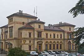 The Villa La Pérolliere | ||
| ||
 Saint-Pierre-la-Palud Location within Auvergne-Rhône-Alpes region  Saint-Pierre-la-Palud | ||
| Coordinates: 45°47′30″N 4°36′44″E / 45.7917°N 4.6122°ECoordinates: 45°47′30″N 4°36′44″E / 45.7917°N 4.6122°E | ||
| Country | France | |
| Region | Auvergne-Rhône-Alpes | |
| Department | Rhône | |
| Arrondissement | Villefranche-sur-Saône | |
| Canton | L'Arbresle | |
| Government | ||
| • Mayor (2008–2014) | Yvon Olivier | |
| Area1 | 7.53 km2 (2.91 sq mi) | |
| Population (2005)2 | 2,207 | |
| • Density | 290/km2 (760/sq mi) | |
| Time zone | UTC+1 (CET) | |
| • Summer (DST) | UTC+2 (CEST) | |
| INSEE/Postal code | 69231 /69210 | |
| Elevation |
259–747 m (850–2,451 ft) (avg. 360 m or 1,180 ft) | |
|
1 French Land Register data, which excludes lakes, ponds, glaciers > 1 km2 (0.386 sq mi or 247 acres) and river estuaries. 2 Population without double counting: residents of multiple communes (e.g., students and military personnel) only counted once. | ||
.svg.png)
Saint-Pierre-la-Palud is a commune in the Rhône department in eastern France.
See also
References
| Wikimedia Commons has media related to Saint-Pierre-la-Palud. |
This article is issued from
Wikipedia.
The text is licensed under Creative Commons - Attribution - Sharealike.
Additional terms may apply for the media files.