Chaponost
| Chaponost | |
|---|---|
| Commune | |
 Church of Chaponost | |
 Chaponost Location within Auvergne-Rhône-Alpes region  Chaponost | |
| Coordinates: 45°42′39″N 4°44′33″E / 45.7108°N 4.7425°ECoordinates: 45°42′39″N 4°44′33″E / 45.7108°N 4.7425°E | |
| Country | France |
| Region | Auvergne-Rhône-Alpes |
| Department | Rhône |
| Arrondissement | Lyon |
| Canton | Brignais |
| Intercommunality | Communauté de communes de la Vallée du Garon |
| Government | |
| • Mayor (2014-2020) | Damien Combet |
| Area1 | 16.32 km2 (6.30 sq mi) |
| Population (2012)2 | 7,963 |
| • Density | 490/km2 (1,300/sq mi) |
| Time zone | UTC+1 (CET) |
| • Summer (DST) | UTC+2 (CEST) |
| INSEE/Postal code | 69043 /69630 |
| Elevation |
180–336 m (591–1,102 ft) (avg. 325 m or 1,066 ft) |
|
1 French Land Register data, which excludes lakes, ponds, glaciers > 1 km2 (0.386 sq mi or 247 acres) and river estuaries. 2 Population without double counting: residents of multiple communes (e.g., students and military personnel) only counted once. | |
Chaponost is a commune in the Rhône department in eastern France.
It is known for its Roman aqueducts.
Monuments
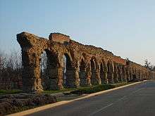
Vestiges of the Roman aqueduct in Chaponost
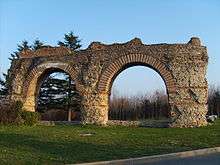
Vestiges of the Roman aqueduct in Chaponost
The Roman aqueduct of the Gier, estimated to be 75 km long, was built under Hadrian's reign during the second century CE to enable water supply of the Roman city of Lugdunum (Lyon) from Mont Pilat (source of the river Gier). Arches of the aqueducts (around 92 arches on 550 m) are located on the territory of the commune, at the site of "Le Plat de l'Air".
Twin towns
Chaponost is twinned with:

See also
References
External links
| Wikimedia Commons has media related to Chaponost. |
This article is issued from
Wikipedia.
The text is licensed under Creative Commons - Attribution - Sharealike.
Additional terms may apply for the media files.