Saint-Bonnet-des-Bruyères
| Saint-Bonnet-des-Bruyères | |
|---|---|
| Commune | |
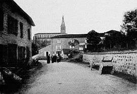 Saint-Bonnet-des-Bruyères, in the early 20th century | |
 Saint-Bonnet-des-Bruyères Location within Auvergne-Rhône-Alpes region  Saint-Bonnet-des-Bruyères | |
| Coordinates: 46°16′15″N 4°28′12″E / 46.2708°N 4.47°ECoordinates: 46°16′15″N 4°28′12″E / 46.2708°N 4.47°E | |
| Country | France |
| Region | Auvergne-Rhône-Alpes |
| Department | Rhône |
| Arrondissement | Villefranche-sur-Saône |
| Canton | Thizy-les-Bourgs |
| Intercommunality | Communauté de communes du Haut-Beaujolais |
| Government | |
| • Mayor (2014–2020) | Martine Cartillier |
| Area1 | 21.20 km2 (8.19 sq mi) |
| Population (2014)2 | 376 |
| • Density | 18/km2 (46/sq mi) |
| Time zone | UTC+1 (CET) |
| • Summer (DST) | UTC+2 (CEST) |
| INSEE/Postal code | 69182 /69790 |
| Elevation | 413–801 m (1,355–2,628 ft) |
|
1 French Land Register data, which excludes lakes, ponds, glaciers > 1 km2 (0.386 sq mi or 247 acres) and river estuaries. 2 Population without double counting: residents of multiple communes (e.g., students and military personnel) only counted once. | |
Saint-Bonnet-des-Bruyères is a commune in the Rhône department in eastern France.
Geography
The river Grosne has its source in the commune.
See also
References
| Wikimedia Commons has media related to Saint-Bonnet-des-Bruyères. |
This article is issued from
Wikipedia.
The text is licensed under Creative Commons - Attribution - Sharealike.
Additional terms may apply for the media files.