Ancy
| Ancy | |
|---|---|
| Commune | |
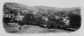 A general view of Ancy, at the beginning of the 20th century | |
 Ancy Location within Auvergne-Rhône-Alpes region  Ancy | |
| Coordinates: 45°50′17″N 4°30′33″E / 45.8381°N 4.5092°ECoordinates: 45°50′17″N 4°30′33″E / 45.8381°N 4.5092°E | |
| Country | France |
| Region | Auvergne-Rhône-Alpes |
| Department | Rhône |
| Arrondissement | Villefranche-sur-Saône |
| Canton | Tarare |
| Intercommunality | Ouest Rhodanien |
| Government | |
| • Mayor (2014-2020) | Christine de Saint-Jean |
| Area1 | 11.84 km2 (4.57 sq mi) |
| Population (2014)2 | 609 |
| • Density | 51/km2 (130/sq mi) |
| Time zone | UTC+1 (CET) |
| • Summer (DST) | UTC+2 (CEST) |
| INSEE/Postal code | 69008 /69490 |
| Elevation |
394–852 m (1,293–2,795 ft) (avg. 460 m or 1,510 ft) |
|
1 French Land Register data, which excludes lakes, ponds, glaciers > 1 km2 (0.386 sq mi or 247 acres) and river estuaries. 2 Population without double counting: residents of multiple communes (e.g., students and military personnel) only counted once. | |
Ancy is a commune in the Rhône department in eastern France.
See also
References
| Wikimedia Commons has media related to Ancy. |
This article is issued from
Wikipedia.
The text is licensed under Creative Commons - Attribution - Sharealike.
Additional terms may apply for the media files.