Saint-Martin-en-Haut
| Saint-Martin-en-Haut | |
|---|---|
| Commune | |
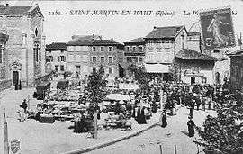 The marketplace in Saint-Martin-en-Haut, in the early 20th century | |
 Saint-Martin-en-Haut Location within Auvergne-Rhône-Alpes region  Saint-Martin-en-Haut | |
| Coordinates: 45°39′38″N 4°33′45″E / 45.6606°N 4.5625°ECoordinates: 45°39′38″N 4°33′45″E / 45.6606°N 4.5625°E | |
| Country | France |
| Region | Auvergne-Rhône-Alpes |
| Department | Rhône |
| Arrondissement | Lyon |
| Canton | Vaugneray |
| Intercommunality | Communauté de communes des Hauts du Lyonnais |
| Government | |
| • Mayor (2008–2014) | Régis Chambe |
| Area1 | 38.64 km2 (14.92 sq mi) |
| Population (2007)2 | 3,889 |
| • Density | 100/km2 (260/sq mi) |
| Time zone | UTC+1 (CET) |
| • Summer (DST) | UTC+2 (CEST) |
| INSEE/Postal code | 69227 /69850 |
| Elevation |
453–911 m (1,486–2,989 ft) (avg. 730 m or 2,400 ft) |
|
1 French Land Register data, which excludes lakes, ponds, glaciers > 1 km2 (0.386 sq mi or 247 acres) and river estuaries. 2 Population without double counting: residents of multiple communes (e.g., students and military personnel) only counted once. | |
Saint-Martin-en-Haut is a commune in the Rhône department in eastern France.
See also
References
| Wikimedia Commons has media related to Saint-Martin-en-Haut. |
This article is issued from
Wikipedia.
The text is licensed under Creative Commons - Attribution - Sharealike.
Additional terms may apply for the media files.