Condrieu
| Condrieu | ||
|---|---|---|
| Commune | ||
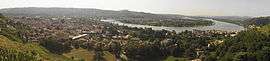 A panoramic view of Condrieu | ||
| ||
 Condrieu Location within Auvergne-Rhône-Alpes region  Condrieu | ||
| Coordinates: 45°27′50″N 4°46′06″E / 45.4639°N 4.7683°ECoordinates: 45°27′50″N 4°46′06″E / 45.4639°N 4.7683°E | ||
| Country | France | |
| Region | Auvergne-Rhône-Alpes | |
| Department | Rhône | |
| Arrondissement | Lyon | |
| Canton | Mornant | |
| Intercommunality | Région de Condrieu | |
| Government | ||
| • Mayor (2001–2008) | Gabriel Montcharmont | |
| Area1 | 9.21 km2 (3.56 sq mi) | |
| Population (2006)2 | 3,702 | |
| • Density | 400/km2 (1,000/sq mi) | |
| Time zone | UTC+1 (CET) | |
| • Summer (DST) | UTC+2 (CEST) | |
| INSEE/Postal code | 69064 /69420 | |
| Elevation |
146–460 m (479–1,509 ft) (avg. 230 m or 750 ft) | |
|
1 French Land Register data, which excludes lakes, ponds, glaciers > 1 km2 (0.386 sq mi or 247 acres) and river estuaries. 2 Population without double counting: residents of multiple communes (e.g., students and military personnel) only counted once. | ||
.svg.png)
Condrieu is a commune in the Rhône department in eastern France.
It is situated on the right bank of the Rhône, some 11 km (6.8 mi) south of Vienne and 44 km south of Lyon, at the foot of the lower slopes of the Mont Monnet. It has an area of 921 hectares and in 1999 it had a population of 3,424. Its altitude ranges from 146 to 460 metres.
Condrieu produces white wine, Condrieu AOC and cheese, the Rigotte de Condrieu.
See also
References
External links
| Wikimedia Commons has media related to Condrieu. |
- Official website
- Local government website
- Website on Condrieu
- Local information on Condrieu
- Gazetteer Entry
This article is issued from
Wikipedia.
The text is licensed under Creative Commons - Attribution - Sharealike.
Additional terms may apply for the media files.