Saint-Pierre-de-Chandieu
| Saint-Pierre-de-Chandieu | ||
|---|---|---|
| Commune | ||
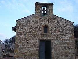 Chapel of St. Thomas | ||
| ||
 Saint-Pierre-de-Chandieu Location within Auvergne-Rhône-Alpes region  Saint-Pierre-de-Chandieu | ||
| Coordinates: 45°38′50″N 5°00′56″E / 45.6472°N 5.0156°ECoordinates: 45°38′50″N 5°00′56″E / 45.6472°N 5.0156°E | ||
| Country | France | |
| Region | Auvergne-Rhône-Alpes | |
| Department | Rhône | |
| Arrondissement | Lyon | |
| Canton | Genas | |
| Intercommunality | Communauté de communes de l'Est lyonnais | |
| Government | ||
| • Mayor (2014-2020) | Raphaël Ibanez | |
| Area1 | 29.28 km2 (11.31 sq mi) | |
| Population (2012)2 | 4,651 | |
| • Density | 160/km2 (410/sq mi) | |
| Time zone | UTC+1 (CET) | |
| • Summer (DST) | UTC+2 (CEST) | |
| INSEE/Postal code | 69289 /69780 | |
| Elevation |
215–369 m (705–1,211 ft) (avg. 365 m or 1,198 ft) | |
|
1 French Land Register data, which excludes lakes, ponds, glaciers > 1 km2 (0.386 sq mi or 247 acres) and river estuaries. 2 Population without double counting: residents of multiple communes (e.g., students and military personnel) only counted once. | ||
.svg.png)
Saint-Pierre-de-Chandieu is a commune in the Rhône department in eastern France.
See also
References
| Wikimedia Commons has media related to Saint-Pierre-de-Chandieu. |
This article is issued from
Wikipedia.
The text is licensed under Creative Commons - Attribution - Sharealike.
Additional terms may apply for the media files.