Saint-Erblon, Mayenne
| Saint-Erblon | |
|---|---|
| Commune | |
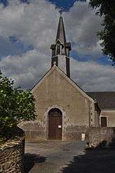 The church in Saint-Erblon | |
 Saint-Erblon Location within Pays de la Loire region  Saint-Erblon | |
| Coordinates: 47°47′17″N 1°09′59″W / 47.7881°N 1.1664°WCoordinates: 47°47′17″N 1°09′59″W / 47.7881°N 1.1664°W | |
| Country | France |
| Region | Pays de la Loire |
| Department | Mayenne |
| Arrondissement | Château-Gontier |
| Canton | Cossé-le-Vivien |
| Intercommunality | Saint-Aignanz–Renazé |
| Government | |
| • Mayor | Olivier Gaucher |
| Area1 | 5.68 km2 (2.19 sq mi) |
| Population (1999)2 | 166 |
| • Density | 29/km2 (76/sq mi) |
| Time zone | UTC+1 (CET) |
| • Summer (DST) | UTC+2 (CEST) |
| INSEE/Postal code | 53214 /53390 |
| Elevation |
65–106 m (213–348 ft) (avg. 101 m or 331 ft) |
|
1 French Land Register data, which excludes lakes, ponds, glaciers > 1 km2 (0.386 sq mi or 247 acres) and river estuaries. 2 Population without double counting: residents of multiple communes (e.g., students and military personnel) only counted once. | |
Saint-Erblon is a commune in the Mayenne department in north-western France.
Geography
The Semnon forms all of the commune's northern border.
See also
References
| Wikimedia Commons has media related to Saint-Erblon (Mayenne). |
This article is issued from
Wikipedia.
The text is licensed under Creative Commons - Attribution - Sharealike.
Additional terms may apply for the media files.