Saint-Georges-le-Fléchard
| Saint-Georges-le-Fléchard | |
|---|---|
| Commune | |
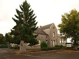 The school and town hall in Saint-Georges-le-Fléchard | |
 Saint-Georges-le-Fléchard Location within Pays de la Loire region  Saint-Georges-le-Fléchard | |
| Coordinates: 48°02′15″N 0°30′31″W / 48.0375°N 0.5086°WCoordinates: 48°02′15″N 0°30′31″W / 48.0375°N 0.5086°W | |
| Country | France |
| Region | Pays de la Loire |
| Department | Mayenne |
| Arrondissement | Mayenne |
| Canton | Meslay-du-Maine |
| Intercommunality | Erve et Charnie |
| Government | |
| • Mayor (2014–2020) | Arlette Leutelier |
| Area1 | 8.44 km2 (3.26 sq mi) |
| Population (2005)2 | 288 |
| • Density | 34/km2 (88/sq mi) |
| Time zone | UTC+1 (CET) |
| • Summer (DST) | UTC+2 (CEST) |
| INSEE/Postal code | 53220 /53480 |
| Elevation |
70–112 m (230–367 ft) (avg. 90 m or 300 ft) |
|
1 French Land Register data, which excludes lakes, ponds, glaciers > 1 km2 (0.386 sq mi or 247 acres) and river estuaries. 2 Population without double counting: residents of multiple communes (e.g., students and military personnel) only counted once. | |
Saint-Georges-le-Fléchard is a commune in the Mayenne department in north-western France.
Geography
The Vaige forms most of the commune's eastern border. Coordinates,48.0375° N, 0.5086° W Population in 2007 was 326.
See also
References
| Wikimedia Commons has media related to Saint-Georges-le-Fléchard. |
This article is issued from
Wikipedia.
The text is licensed under Creative Commons - Attribution - Sharealike.
Additional terms may apply for the media files.