Montenay
| Montenay | |
|---|---|
| Commune | |
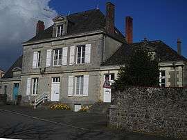 The old town hall in Montenay | |
 Montenay Location within Pays de la Loire region  Montenay | |
| Coordinates: 48°17′21″N 0°53′29″W / 48.2892°N 0.8914°WCoordinates: 48°17′21″N 0°53′29″W / 48.2892°N 0.8914°W | |
| Country | France |
| Region | Pays de la Loire |
| Department | Mayenne |
| Arrondissement | Mayenne |
| Canton | Ernée |
| Government | |
| • Mayor (2008–2014) | Jacqueline Leray |
| Area1 | 37.20 km2 (14.36 sq mi) |
| Population (2006)2 | 1,416 |
| • Density | 38/km2 (99/sq mi) |
| Time zone | UTC+1 (CET) |
| • Summer (DST) | UTC+2 (CEST) |
| INSEE/Postal code | 53155 /53500 |
| Elevation |
94–208 m (308–682 ft) (avg. 109 m or 358 ft) |
|
1 French Land Register data, which excludes lakes, ponds, glaciers > 1 km2 (0.386 sq mi or 247 acres) and river estuaries. 2 Population without double counting: residents of multiple communes (e.g., students and military personnel) only counted once. | |
Montenay is a commune in the Mayenne department in north-western France.
See also
| Wikimedia Commons has media related to Montenay. |
This article is issued from
Wikipedia.
The text is licensed under Creative Commons - Attribution - Sharealike.
Additional terms may apply for the media files.