Le Horps
| Le Horps | |
|---|---|
| Commune | |
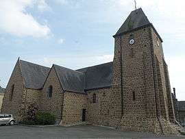 The church of Saint Pierre and Saint Paul, in Le Horps | |
 Le Horps Location within Pays de la Loire region  Le Horps | |
| Coordinates: 48°23′50″N 0°27′36″W / 48.3972°N 0.46°WCoordinates: 48°23′50″N 0°27′36″W / 48.3972°N 0.46°W | |
| Country | France |
| Region | Pays de la Loire |
| Department | Mayenne |
| Arrondissement | Mayenne |
| Canton | Lassay-les-Châteaux |
| Government | |
| • Mayor (2008–2014) | Gérard Dujarrier |
| Area1 | 23.27 km2 (8.98 sq mi) |
| Population (2006)2 | 754 |
| • Density | 32/km2 (84/sq mi) |
| Time zone | UTC+1 (CET) |
| • Summer (DST) | UTC+2 (CEST) |
| INSEE/Postal code | 53116 /53640 |
| Elevation |
174–301 m (571–988 ft) (avg. 270 m or 890 ft) |
|
1 French Land Register data, which excludes lakes, ponds, glaciers > 1 km2 (0.386 sq mi or 247 acres) and river estuaries. 2 Population without double counting: residents of multiple communes (e.g., students and military personnel) only counted once. | |
Le Horps is a commune in the Mayenne department in north-western France.
Demography
| Year | 1836 | 1846 | 1856 | 1866 | 1876 | 1886 | 1896 | 1906 |
|---|---|---|---|---|---|---|---|---|
| Population | 1682 | 1564 | 1583 | 1634 | 1584 | 1454 | 1336 | 1243 |
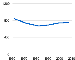
| Year | 1962 | 1968 | 1975 | 1982 | 1990 | 1999 | 2005 |
|---|---|---|---|---|---|---|---|
| Population | 836 | 735 | 707 | 671 | 684 | 734 | 744 |
| From the year 1962 on: No double counting—residents of multiple communes (e.g. students and military personnel) are counted only once. | |||||||
See also
References
- ↑
- ↑ "Le Horps sur le site de l'Insee". Archived from the original on 2007-10-10. Retrieved 2008-08-19.
| Wikimedia Commons has media related to Le Horps. |
This article is issued from
Wikipedia.
The text is licensed under Creative Commons - Attribution - Sharealike.
Additional terms may apply for the media files.