Ménil
| Ménil | ||
|---|---|---|
| Commune | ||
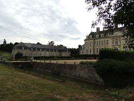 The Chateau de Magnanne, in Ménil | ||
| ||
 Ménil Location within Pays de la Loire region  Ménil | ||
| Coordinates: 47°46′34″N 0°40′30″W / 47.7761°N 0.675°WCoordinates: 47°46′34″N 0°40′30″W / 47.7761°N 0.675°W | ||
| Country | France | |
| Region | Pays de la Loire | |
| Department | Mayenne | |
| Arrondissement | Château-Gontier | |
| Canton | Azé | |
| Government | ||
| • Mayor (2001–2008) | Jean-Pierre Ecard | |
| Area1 | 28.7 km2 (11.1 sq mi) | |
| Population (2006)2 | 920 | |
| • Density | 32/km2 (83/sq mi) | |
| Time zone | UTC+1 (CET) | |
| • Summer (DST) | UTC+2 (CEST) | |
| INSEE/Postal code | 53150 /53200 | |
| Elevation |
19–83 m (62–272 ft) (avg. 28 m or 92 ft) | |
|
1 French Land Register data, which excludes lakes, ponds, glaciers > 1 km2 (0.386 sq mi or 247 acres) and river estuaries. 2 Population without double counting: residents of multiple communes (e.g., students and military personnel) only counted once. | ||

Ménil is a commune in the Mayenne department in north-western France. Its population in the census of 1999 was of 785 inhabitants.
It is integrated in the Community of Pays de Château-Gontier.
See also
| Wikimedia Commons has media related to Ménil. |
This article is issued from
Wikipedia.
The text is licensed under Creative Commons - Attribution - Sharealike.
Additional terms may apply for the media files.