Parné-sur-Roc
| Parné-sur-Roc | |
|---|---|
| Commune | |
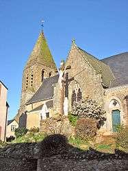 The church of Saint Pierre, in Parné-sur-Roc | |
 Parné-sur-Roc Location within Pays de la Loire region  Parné-sur-Roc | |
| Coordinates: 48°00′23″N 0°40′02″W / 48.0064°N 0.6672°WCoordinates: 48°00′23″N 0°40′02″W / 48.0064°N 0.6672°W | |
| Country | France |
| Region | Pays de la Loire |
| Department | Mayenne |
| Arrondissement | Laval |
| Canton | L'Huisserie |
| Intercommunality | CA Laval |
| Government | |
| • Mayor (2008–2014) | Élisabeth Pannard |
| Area1 | 23.74 km2 (9.17 sq mi) |
| Population (2006)2 | 1,174 |
| • Density | 49/km2 (130/sq mi) |
| Time zone | UTC+1 (CET) |
| • Summer (DST) | UTC+2 (CEST) |
| INSEE/Postal code | 53175 /53260 |
| Elevation |
38–106 m (125–348 ft) (avg. 81 m or 266 ft) |
|
1 French Land Register data, which excludes lakes, ponds, glaciers > 1 km2 (0.386 sq mi or 247 acres) and river estuaries. 2 Population without double counting: residents of multiple communes (e.g., students and military personnel) only counted once. | |
Parné-sur-Roc is a commune in the Mayenne department in north-western France.
See also
| Wikimedia Commons has media related to Parné-sur-Roc. |
This article is issued from
Wikipedia.
The text is licensed under Creative Commons - Attribution - Sharealike.
Additional terms may apply for the media files.