Arrondissement of Château-Gontier
| Château-Gontier | |
|---|---|
| Arrondissement | |
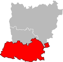 Location of the arrondissement in Mayenne | |
| Country | France |
| Region | Pays de la Loire |
| Department | Mayenne |
| Communes | 83 |
| Subprefecture | Château-Gontier |
| Area¹ | |
| • Total | 1,527 km2 (590 sq mi) |
| Population (2014) | |
| • Total | 73,186 |
| • Density | 48/km2 (120/sq mi) |
| ¹ French Land Register data, which exclude lakes, ponds, and glaciers larger than 1 km² as well as the estuaries of rivers. | |
The arrondissement of Château-Gontier is an arrondissement of France in the Mayenne department in the Pays de la Loire region. Since the March 2016 reorganization of the arrondissements of Mayenne, it has 83 communes.[1]
Composition
Cantons
The cantons of the arrondissement of Château-Gontier are:
- Azé
- Château-Gontier
- Cossé-le-Vivien
- Meslay-du-Maine (partly)
Communes
The communes of the arrondissement of Château-Gontier, and their INSEE codes, are:
- Argenton-Notre-Dame (53006)
- Arquenay (53009)
- Astillé (53011)
- Athée (53012)
- Azé (53014)
- Ballots (53018)
- Bannes (53019)
- La Bazouge-de-Chemeré (53022)
- Bazougers (53025)
- Beaumont-Pied-de-Bœuf (53027)
- Bierné (53029)
- Le Bignon-du-Maine (53030)
- La Boissière (53033)
- Bouchamps-lès-Craon (53035)
- Bouère (53036)
- Bouessay (53037)
- Brains-sur-les-Marches (53041)
- Le Buret (53046)
- La Chapelle-Craonnaise (53058)
- Château-Gontier (53062)
- Châtelain (53063)
- Chemazé (53066)
- Chémeré-le-Roi (53067)
- Chérancé (53068)
- Congrier (53073)
- Cosmes (53075)
- Cossé-en-Champagne (53076)
- Cossé-le-Vivien (53077)
- Coudray (53078)
- Courbeveille (53082)
- Craon (53084)
- La Cropte (53087)
- Cuillé (53088)
- Daon (53089)
- Denazé (53090)
- Fontaine-Couverte (53098)
- Fromentières (53101)
- Gastines (53102)
- Gennes-sur-Glaize (53104)
- Grez-en-Bouère (53110)
- Houssay (53117)
- Laubrières (53128)
- Livré-la-Touche (53135)
- Loigné-sur-Mayenne (53136)
- Longuefuye (53138)
- Maisoncelles-du-Maine (53143)
- Marigné-Peuton (53145)
- Mée (53148)
- Ménil (53150)
- Méral (53151)
- Meslay-du-Maine (53152)
- Niafles (53165)
- Origné (53172)
- Peuton (53178)
- Pommerieux (53180)
- Préaux (53184)
- Prée-d'Anjou (53124)
- Quelaines-Saint-Gault (53186)
- Renazé (53188)
- La Roë (53191)
- La Rouaudière (53192)
- Ruillé-Froid-Fonds (53193)
- Saint-Aignan-sur-Roë (53197)
- Saint-Brice (53203)
- Saint-Charles-la-Forêt (53206)
- Saint-Denis-d'Anjou (53210)
- Saint-Denis-du-Maine (53212)
- Saint-Erblon (53214)
- Saint-Fort (53215)
- Saint-Laurent-des-Mortiers (53231)
- Saint-Loup-du-Dorat (53233)
- Saint-Martin-du-Limet (53240)
- Saint-Michel-de-Feins (53241)
- Saint-Michel-de-la-Roë (53242)
- Saint-Poix (53250)
- Saint-Quentin-les-Anges (53251)
- Saint-Saturnin-du-Limet (53253)
- Saint-Sulpice (53254)
- La Selle-Craonnaise (53258)
- Senonnes (53259)
- Simplé (53260)
- Val-du-Maine (53017)
- Villiers-Charlemagne (53273)
References
- ↑ "Arrêté préfectoral, 24 March 2016" (PDF). Retrieved 2017-08-04.
External links
This article is issued from
Wikipedia.
The text is licensed under Creative Commons - Attribution - Sharealike.
Additional terms may apply for the media files.