Saint-Christophe-du-Luat
| Saint-Christophe-du-Luat | |
|---|---|
| Commune | |
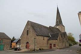 The parish church in Saint-Christophe-du-Luat | |
 Saint-Christophe-du-Luat Location within Pays de la Loire region  Saint-Christophe-du-Luat | |
| Coordinates: 48°08′04″N 0°27′36″W / 48.1344°N 0.46°WCoordinates: 48°08′04″N 0°27′36″W / 48.1344°N 0.46°W | |
| Country | France |
| Region | Pays de la Loire |
| Department | Mayenne |
| Arrondissement | Mayenne |
| Canton | Évron |
| Intercommunality | Pays d'Évron |
| Government | |
| • Mayor (2014–2020) | Adélaïde Dejardin |
| Area1 | 19.12 km2 (7.38 sq mi) |
| Population (1999)2 | 553 |
| • Density | 29/km2 (75/sq mi) |
| Time zone | UTC+1 (CET) |
| • Summer (DST) | UTC+2 (CEST) |
| INSEE/Postal code | 53207 /53150 |
| Elevation |
74–137 m (243–449 ft) (avg. 92 m or 302 ft) |
|
1 French Land Register data, which excludes lakes, ponds, glaciers > 1 km2 (0.386 sq mi or 247 acres) and river estuaries. 2 Population without double counting: residents of multiple communes (e.g., students and military personnel) only counted once. | |
Saint-Christophe-du-Luat is a commune in the Mayenne department in north-western France.
See also
References
| Wikimedia Commons has media related to Saint-Christophe-du-Luat. |
This article is issued from
Wikipedia.
The text is licensed under Creative Commons - Attribution - Sharealike.
Additional terms may apply for the media files.