Grazay
| Grazay | |
|---|---|
| Commune | |
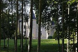 The Logis du Bois, in Grazay | |
 Grazay Location within Pays de la Loire region  Grazay | |
| Coordinates: 48°17′28″N 0°28′51″W / 48.2911°N 0.4808°WCoordinates: 48°17′28″N 0°28′51″W / 48.2911°N 0.4808°W | |
| Country | France |
| Region | Pays de la Loire |
| Department | Mayenne |
| Arrondissement | Mayenne |
| Canton | Lassay-les-Châteaux |
| Government | |
| • Mayor (2014–2020) | Didier Boittin |
| Area1 | 16.97 km2 (6.55 sq mi) |
| Population (2014)2 | 639 |
| • Density | 38/km2 (98/sq mi) |
| Time zone | UTC+1 (CET) |
| • Summer (DST) | UTC+2 (CEST) |
| INSEE/Postal code | 53109 /53440 |
| Elevation |
128–216 m (420–709 ft) (avg. 133 m or 436 ft) |
|
1 French Land Register data, which excludes lakes, ponds, glaciers > 1 km2 (0.386 sq mi or 247 acres) and river estuaries. 2 Population without double counting: residents of multiple communes (e.g., students and military personnel) only counted once. | |
Grazay is a village and commune in the Mayenne département of north-western France.
See also
| Wikimedia Commons has media related to Grazay. |
This article is issued from
Wikipedia.
The text is licensed under Creative Commons - Attribution - Sharealike.
Additional terms may apply for the media files.