La Chapelle-Anthenaise
| La Chapelle-Anthenaise | |
|---|---|
| Commune | |
 La Chapelle-Anthenaise Location within Pays de la Loire region  La Chapelle-Anthenaise | |
| Coordinates: 48°07′24″N 0°40′34″W / 48.1233°N 0.6761°WCoordinates: 48°07′24″N 0°40′34″W / 48.1233°N 0.6761°W | |
| Country | France |
| Region | Pays de la Loire |
| Department | Mayenne |
| Arrondissement | Laval |
| Canton | Bonchamp-lès-Laval |
| Intercommunality | CA Laval |
| Government | |
| • Mayor (2008–2014) | Jean Brault |
| Area1 | 19.89 km2 (7.68 sq mi) |
| Population (2006)2 | 859 |
| • Density | 43/km2 (110/sq mi) |
| Time zone | UTC+1 (CET) |
| • Summer (DST) | UTC+2 (CEST) |
| INSEE/Postal code | 53056 /53950 |
| Elevation |
77–147 m (253–482 ft) (avg. 138 m or 453 ft) |
|
1 French Land Register data, which excludes lakes, ponds, glaciers > 1 km2 (0.386 sq mi or 247 acres) and river estuaries. 2 Population without double counting: residents of multiple communes (e.g., students and military personnel) only counted once. | |
La Chapelle-Anthenaise is a commune in the Mayenne department in north-western France.
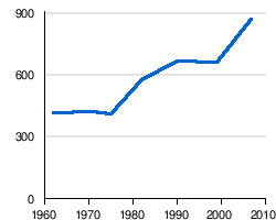
Demographic evolution
References
See also
| Wikimedia Commons has media related to La Chapelle-Anthenaise. |
This article is issued from
Wikipedia.
The text is licensed under Creative Commons - Attribution - Sharealike.
Additional terms may apply for the media files.