Montaudin
| Montaudin | |
|---|---|
| Commune | |
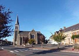 The church of Our Lady, in Montaudin | |
 Montaudin Location within Pays de la Loire region  Montaudin | |
| Coordinates: 48°23′12″N 0°59′14″W / 48.3867°N 0.9872°WCoordinates: 48°23′12″N 0°59′14″W / 48.3867°N 0.9872°W | |
| Country | France |
| Region | Pays de la Loire |
| Department | Mayenne |
| Arrondissement | Mayenne |
| Canton | Gorron |
| Government | |
| • Mayor (2008–2014) | Bernard Ory |
| Area1 | 21.66 km2 (8.36 sq mi) |
| Population (2006)2 | 912 |
| • Density | 42/km2 (110/sq mi) |
| Time zone | UTC+1 (CET) |
| • Summer (DST) | UTC+2 (CEST) |
| INSEE/Postal code | 53154 /53220 |
| Elevation |
150–227 m (492–745 ft) (avg. 206 m or 676 ft) |
|
1 French Land Register data, which excludes lakes, ponds, glaciers > 1 km2 (0.386 sq mi or 247 acres) and river estuaries. 2 Population without double counting: residents of multiple communes (e.g., students and military personnel) only counted once. | |
Montaudin is a commune in the Mayenne department in north-western France.
See also
| Wikimedia Commons has media related to Montaudin. |
This article is issued from
Wikipedia.
The text is licensed under Creative Commons - Attribution - Sharealike.
Additional terms may apply for the media files.