Méral
| Méral | ||
|---|---|---|
| Commune | ||
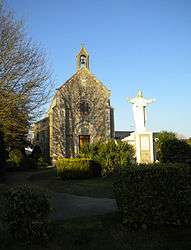 The Chapel of the Saint, in Méral | ||
| ||
 Méral Location within Pays de la Loire region  Méral | ||
| Coordinates: 47°57′41″N 0°58′46″W / 47.9614°N 0.9794°WCoordinates: 47°57′41″N 0°58′46″W / 47.9614°N 0.9794°W | ||
| Country | France | |
| Region | Pays de la Loire | |
| Department | Mayenne | |
| Arrondissement | Château-Gontier | |
| Canton | Cossé-le-Vivien | |
| Government | ||
| • Mayor (2008–2014) | Jean-Marc Foucher | |
| Area1 | 29.5 km2 (11.4 sq mi) | |
| Population (2006)2 | 1,042 | |
| • Density | 35/km2 (91/sq mi) | |
| Time zone | UTC+1 (CET) | |
| • Summer (DST) | UTC+2 (CEST) | |
| INSEE/Postal code | 53151 /53230 | |
| Elevation |
59–102 m (194–335 ft) (avg. 95 m or 312 ft) | |
|
1 French Land Register data, which excludes lakes, ponds, glaciers > 1 km2 (0.386 sq mi or 247 acres) and river estuaries. 2 Population without double counting: residents of multiple communes (e.g., students and military personnel) only counted once. | ||

Méral is a commune in the Mayenne department in north-western France.
Geography
The Oudon River forms part of the commune's north-eastern border.
See also
External links
| Wikimedia Commons has media related to Méral. |
This article is issued from
Wikipedia.
The text is licensed under Creative Commons - Attribution - Sharealike.
Additional terms may apply for the media files.