Le Pas
| Le Pas | |
|---|---|
| Commune | |
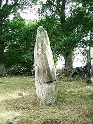 The Menhir of Saint Civière, in Le Pas | |
 Le Pas Location within Pays de la Loire region  Le Pas | |
| Coordinates: 48°25′51″N 0°41′55″W / 48.4308°N 0.6986°WCoordinates: 48°25′51″N 0°41′55″W / 48.4308°N 0.6986°W | |
| Country | France |
| Region | Pays de la Loire |
| Department | Mayenne |
| Arrondissement | Mayenne |
| Canton | Gorron |
| Government | |
| • Mayor (2014–2020) | Martine Letissier |
| Area1 | 21.90 km2 (8.46 sq mi) |
| Population (2006)2 | 523 |
| • Density | 24/km2 (62/sq mi) |
| Time zone | UTC+1 (CET) |
| • Summer (DST) | UTC+2 (CEST) |
| INSEE/Postal code | 53176 /53300 |
| Elevation |
98–190 m (322–623 ft) (avg. 95 m or 312 ft) |
|
1 French Land Register data, which excludes lakes, ponds, glaciers > 1 km2 (0.386 sq mi or 247 acres) and river estuaries. 2 Population without double counting: residents of multiple communes (e.g., students and military personnel) only counted once. | |
Le Pas is a commune in the Mayenne department in north-western France. Le Pas is a village located in the north of the Department of Mayenne. It is 10 km from Gorron, 42 km from Laval and 18 km from Mayenne.
Sites of interest
The menhir of Saint-Civière is an historic monument.
The church of St. Martin, was dedicated on October 8, 1787 and has two bells named Renee and Magdelaine.
Nearest settlements
Nearest settlements | |
|---|---|
See also
| Wikimedia Commons has media related to Le Pas (Mayenne). |
This article is issued from
Wikipedia.
The text is licensed under Creative Commons - Attribution - Sharealike.
Additional terms may apply for the media files.