Thubœuf
| Thubœuf | |
|---|---|
| Commune | |
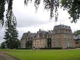 The Château de Chantepie, in Thubœuf | |
 Thubœuf Location within Pays de la Loire region  Thubœuf | |
| Coordinates: 48°30′10″N 0°26′59″W / 48.5028°N 0.4497°WCoordinates: 48°30′10″N 0°26′59″W / 48.5028°N 0.4497°W | |
| Country | France |
| Region | Pays de la Loire |
| Department | Mayenne |
| Arrondissement | Mayenne |
| Canton | Lassay-les-Châteaux |
| Government | |
| • Mayor (2008–2014) | Rémy Pottier |
| Area1 | 13.88 km2 (5.36 sq mi) |
| Population (2006)2 | 276 |
| • Density | 20/km2 (52/sq mi) |
| Time zone | UTC+1 (CET) |
| • Summer (DST) | UTC+2 (CEST) |
| INSEE/Postal code | 53263 /53110 |
| Elevation |
114–165 m (374–541 ft) (avg. 120 m or 390 ft) |
|
1 French Land Register data, which excludes lakes, ponds, glaciers > 1 km2 (0.386 sq mi or 247 acres) and river estuaries. 2 Population without double counting: residents of multiple communes (e.g., students and military personnel) only counted once. | |
Thubœuf is a commune in the Mayenne department in north-western France.
See also
| Wikimedia Commons has media related to Thubœuf. |
This article is issued from
Wikipedia.
The text is licensed under Creative Commons - Attribution - Sharealike.
Additional terms may apply for the media files.