Saint-Émilion
| Saint-Émilion | ||
|---|---|---|
| Commune | ||
 | ||
| ||
 Saint-Émilion Location within Nouvelle-Aquitaine region  Saint-Émilion | ||
| Coordinates: 44°53′37″N 0°09′17″W / 44.8936°N 0.1547°WCoordinates: 44°53′37″N 0°09′17″W / 44.8936°N 0.1547°W | ||
| Country | France | |
| Region | Nouvelle-Aquitaine | |
| Department | Gironde | |
| Arrondissement | Libourne | |
| Canton | Les Coteaux de Dordogne | |
| Intercommunality | Saint-Émilion | |
| Government | ||
| • Mayor (2008–2014) | Bernard Lauret | |
| Area1 | 27.02 km2 (10.43 sq mi) | |
| Population (2012)2 | 1,931 | |
| • Density | 71/km2 (190/sq mi) | |
| Time zone | UTC+1 (CET) | |
| • Summer (DST) | UTC+2 (CEST) | |
| INSEE/Postal code | 33394 /33330 | |
| Elevation |
3–107 m (9.8–351.0 ft) (avg. 23 m or 75 ft) | |
|
1 French Land Register data, which excludes lakes, ponds, glaciers > 1 km2 (0.386 sq mi or 247 acres) and river estuaries. 2 Population without double counting: residents of multiple communes (e.g., students and military personnel) only counted once. | ||
.svg.png)
| UNESCO World Heritage site | |
|---|---|
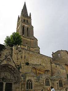 Monolithic church of Saint-Émilion and its bell tower | |
| Criteria | Cultural: iii, iv |
| Reference | 932 |
| Inscription | 1999 (23rd Session) |
| Area | 7,847 ha |
| Buffer zone | 5,101 ha |
Saint-Émilion (pronounced [sɛ̃t‿e.mil.jɔ̃]; Gascon: Sent Milion) is a commune in the Gironde department in Nouvelle-Aquitaine in south-western France.
History
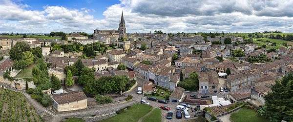
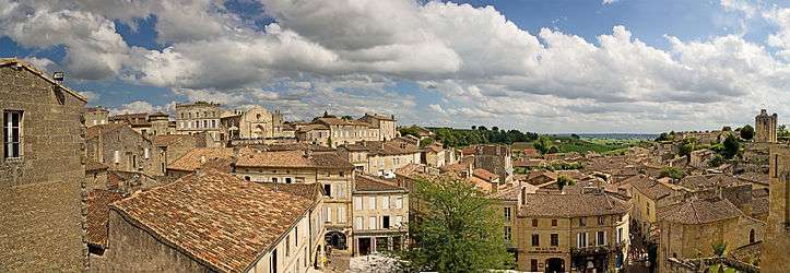
Saint-Émilion's history goes back to prehistoric times and is a UNESCO World Heritage Site, with fascinating Romanesque churches and ruins stretching all along steep and narrow streets.
The Romans planted vineyards in what was to become Saint-Émilion as early as the 2nd century. In the 4th century, the Latin poet Ausonius lauded the fruit of the bountiful vine.
The town, previously called Ascumbas,[1] was renamed after the monk Émilion (d.767[2]), a travelling confessor, who settled in a hermitage carved into the rock there in the 8th century. The monks who followed him started up the commercial wine production in the area.
Geography
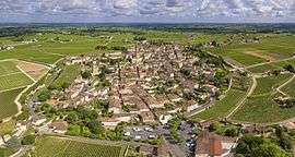
Saint-Émilion is located 35 km (22 mi) northeast of Bordeaux, between Libourne and Castillon-la-Bataille.
Population
| Historical population | ||
|---|---|---|
| Year | Pop. | ±% |
| 1800 | 2,761 | — |
| 1851 | 2,828 | +2.4% |
| 1861 | 3,014 | +6.6% |
| 1872 | 3,059 | +1.5% |
| 1881 | 3,034 | −0.8% |
| 1891 | 3,233 | +6.6% |
| 1901 | 3,392 | +4.9% |
| 1911 | 3,408 | +0.5% |
| 1921 | 3,165 | −7.1% |
| 1931 | 3,367 | +6.4% |
| 1946 | 3,232 | −4.0% |
| 1954 | 3,252 | +0.6% |
| 1962 | 3,335 | +2.6% |
| 1968 | 3,403 | +2.0% |
| 1975 | 3,323 | −2.4% |
| 1982 | 3,010 | −9.4% |
| 1990 | 2,799 | −7.0% |
| 1999 | 2,345 | −16.2% |
| 2006 | 2,124 | −9.4% |
| 2007 | 2,090 | −1.6% |
| 2008 | 2,020 | −3.3% |
| 2012 | 1,931 | −4.4% |
Sights
- Romanesque church
- Monolithic church, carved from a limestone cliff
Wine
Saint-Émilion is one of the principal red wine areas of Bordeaux along with the Médoc, Graves and Pomerol. The region is much smaller than the Médoc and adjoins Pomerol. As in Pomerol and the other appellations on the right bank of the Gironde, the primary grape varieties used are the Merlot and Cabernet Franc, with relatively small amounts of Cabernet Sauvignon also being used by some châteaux.
Saint Émilion wines were not included in the 1855 Bordeaux classification. The first formal classification in Saint-Émilion was made in 1955. Unlike the 1855 classification, it is regularly revised.
Saint-Emilion Jazz Festival
Since 2012, Saint-Emilion hosts a Jazz Festival at the end of July.[3]
Personalities
See also
References
- ↑ "The Monk Émilion". saint-emilion tourisme. Retrieved Sep 30, 2018.
- ↑ "Bordeaux". Catholic Encyclopedia. Retrieved Sep 30, 2018.
- ↑ "Saint-Emilion Jazz Festival - Site Officiel | Éditions passées". www.saint-emilion-jazz-festival.com (in French). Retrieved 2018-08-02.
External links
| Wikimedia Commons has media related to Saint-Émilion. |
- Official website
- Saint-Émilion tourist office website
- aerial photography of the Saint-Émilion and Aquitaine area
- Cash-strapped French wine town Saint Emilion sells off historical monument RFI English