Le Pian-sur-Garonne
| Le Pian-sur-Garonne | |
|---|---|
| Commune | |
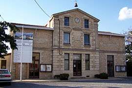 Town hall | |
 Le Pian-sur-Garonne Location within Nouvelle-Aquitaine region  Le Pian-sur-Garonne | |
| Coordinates: 44°35′12″N 0°12′39″W / 44.5867°N 0.2108°WCoordinates: 44°35′12″N 0°12′39″W / 44.5867°N 0.2108°W | |
| Country | France |
| Region | Nouvelle-Aquitaine |
| Department | Gironde |
| Arrondissement | Langon |
| Canton | L'Entre-Deux-Mers |
| Intercommunality | Coteaux Macariens |
| Government | |
| • Mayor (2008–2014) | Alain Bellard |
| Area1 | 6.35 km2 (2.45 sq mi) |
| Population (2008)2 | 686 |
| • Density | 110/km2 (280/sq mi) |
| Time zone | UTC+1 (CET) |
| • Summer (DST) | UTC+2 (CEST) |
| INSEE/Postal code | 33323 /33490 |
| Elevation |
2–116 m (6.6–380.6 ft) (avg. 110 m or 360 ft) |
|
1 French Land Register data, which excludes lakes, ponds, glaciers > 1 km2 (0.386 sq mi or 247 acres) and river estuaries. 2 Population without double counting: residents of multiple communes (e.g., students and military personnel) only counted once. | |
Le Pian-sur-Garonne is a commune in the Gironde department in Nouvelle-Aquitaine in southwestern France.
Population
| Historical population | ||
|---|---|---|
| Year | Pop. | ±% |
| 1962 | 417 | — |
| 1968 | 429 | +2.9% |
| 1975 | 432 | +0.7% |
| 1982 | 460 | +6.5% |
| 1990 | 517 | +12.4% |
| 1999 | 609 | +17.8% |
| 2008 | 686 | +12.6% |
See also
References
| Wikimedia Commons has media related to Le Pian-sur-Garonne. |
| Authority control |
|---|
This article is issued from
Wikipedia.
The text is licensed under Creative Commons - Attribution - Sharealike.
Additional terms may apply for the media files.