Cérons
| Cérons | |
|---|---|
| Commune | |
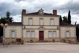 Town hall | |
 Cérons Location within Nouvelle-Aquitaine region  Cérons | |
| Coordinates: 44°37′56″N 0°20′07″W / 44.6322°N 0.3353°WCoordinates: 44°37′56″N 0°20′07″W / 44.6322°N 0.3353°W | |
| Country | France |
| Region | Nouvelle-Aquitaine |
| Department | Gironde |
| Arrondissement | Langon |
| Canton | Les Landes des Graves |
| Intercommunality | Canton de Podensac |
| Government | |
| • Mayor (2008–2014) | Patrick Soulé |
| Area1 | 7.83 km2 (3.02 sq mi) |
| Population (2008)2 | 1,696 |
| • Density | 220/km2 (560/sq mi) |
| Time zone | UTC+1 (CET) |
| • Summer (DST) | UTC+2 (CEST) |
| INSEE/Postal code | 33120 /33720 |
| Elevation |
0–27 m (0–89 ft) (avg. 14 m or 46 ft) |
|
1 French Land Register data, which excludes lakes, ponds, glaciers > 1 km2 (0.386 sq mi or 247 acres) and river estuaries. 2 Population without double counting: residents of multiple communes (e.g., students and military personnel) only counted once. | |
Cérons is a commune in the Gironde department in Nouvelle-Aquitaine in southwestern France.
Population
| Historical population | ||
|---|---|---|
| Year | Pop. | ±% |
| 1962 | 1,229 | — |
| 1968 | 1,241 | +1.0% |
| 1975 | 1,281 | +3.2% |
| 1982 | 1,308 | +2.1% |
| 1990 | 1,319 | +0.8% |
| 1999 | 1,347 | +2.1% |
| 2008 | 1,696 | +25.9% |
See also
References
| Wikimedia Commons has media related to Cérons. |
This article is issued from
Wikipedia.
The text is licensed under Creative Commons - Attribution - Sharealike.
Additional terms may apply for the media files.