Targon
| Targon | ||
|---|---|---|
| Commune | ||
 | ||
| ||
 Targon Location within Nouvelle-Aquitaine region  Targon | ||
| Coordinates: 44°44′08″N 0°15′45″W / 44.7356°N 0.2625°WCoordinates: 44°44′08″N 0°15′45″W / 44.7356°N 0.2625°W | ||
| Country | France | |
| Region | Nouvelle-Aquitaine | |
| Department | Gironde | |
| Arrondissement | Langon | |
| Canton | L'Entre-Deux-Mers | |
| Intercommunality | Targonnais | |
| Government | ||
| • Mayor (2014–2020) | Richard Pezat | |
| Area1 | 25.88 km2 (9.99 sq mi) | |
| Population (2015)2 | 2,047 | |
| • Density | 79/km2 (200/sq mi) | |
| Time zone | UTC+1 (CET) | |
| • Summer (DST) | UTC+2 (CEST) | |
| INSEE/Postal code | 33523 /33760 | |
| Elevation |
37–118 m (121–387 ft) (avg. 57 m or 187 ft) | |
|
1 French Land Register data, which excludes lakes, ponds, glaciers > 1 km2 (0.386 sq mi or 247 acres) and river estuaries. 2 Population without double counting: residents of multiple communes (e.g., students and military personnel) only counted once. | ||
.svg.png)
Targon is a commune in the Gironde department in Nouvelle-Aquitaine in southwestern France.
Population
| Historical population | ||
|---|---|---|
| Year | Pop. | ±% |
| 1962 | 1,084 | — |
| 1968 | 1,132 | +4.4% |
| 1975 | 1,195 | +5.6% |
| 1982 | 1,435 | +20.1% |
| 1990 | 1,609 | +12.1% |
| 1999 | 1,685 | +4.7% |
| 2005 | 1,844 | +9.4% |
| 2010 | 1,851 | +0.4% |
| 2015 | 2,047 | +10.6% |
Sights and monuments
- Église Saint-Romain de Targon, 12th century Romanesque church, listed as a monument historique since 1925.[1]
- Église de Montarouch, 13th century Romanesque church, once the property of the Knights Hospitaller, now in ruins, listed as a monument historique since 1925.[2]
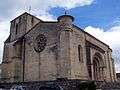 Saint-Romain church, south west view (June 2013)
 South façade and doorway to the church (June 2013)
 Doorway (June 2013)
 Ruins of Montarouch church, south view (June 2013)
 Montarouch church, east view (June 2013)
 Monument to the dead in front of Saint-Romain church (June 2013)
See also
References
| Wikimedia Commons has media related to Targon. |
- ↑ Ministry of Culture: Eglise Saint-Romain (in French)
- ↑ Ministry of Culture: Ruines de l'église de Montarouch (in French)
| Authority control |
|---|
This article is issued from
Wikipedia.
The text is licensed under Creative Commons - Attribution - Sharealike.
Additional terms may apply for the media files.