Vayres, Gironde
| Vayres | |
|---|---|
| Commune | |
 Chateau | |
 Vayres Location within Nouvelle-Aquitaine region  Vayres | |
| Coordinates: 44°53′53″N 0°18′47″W / 44.8981°N 0.3131°WCoordinates: 44°53′53″N 0°18′47″W / 44.8981°N 0.3131°W | |
| Country | France |
| Region | Nouvelle-Aquitaine |
| Department | Gironde |
| Arrondissement | Libourne |
| Canton | Le Libournais-Fronsadais |
| Government | |
| • Mayor (2008–2014) | Hélène Maidon |
| Area1 | 14.46 km2 (5.58 sq mi) |
| Population (2012)2 | 3,543 |
| • Density | 250/km2 (630/sq mi) |
| Time zone | UTC+1 (CET) |
| • Summer (DST) | UTC+2 (CEST) |
| INSEE/Postal code | 33539 /33870 |
| Elevation |
2–39 m (6.6–128.0 ft) (avg. 12 m or 39 ft) |
|
1 French Land Register data, which excludes lakes, ponds, glaciers > 1 km2 (0.386 sq mi or 247 acres) and river estuaries. 2 Population without double counting: residents of multiple communes (e.g., students and military personnel) only counted once. | |
Vayres is a commune in the Gironde department in Nouvelle-Aquitaine in southwestern France.
Population
| Historical population | ||
|---|---|---|
| Year | Pop. | ±% |
| 1962 | 1,853 | — |
| 1968 | 1,845 | −0.4% |
| 1975 | 2,295 | +24.4% |
| 1982 | 2,361 | +2.9% |
| 1990 | 2,491 | +5.5% |
| 1999 | 2,631 | +5.6% |
| 2008 | 3,280 | +24.7% |
Sights
- The Château de Vayres (Vayres Castle). It was remodeled by the 16th-century French engineer Louis de Foix, deceased 1611.
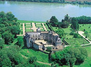
Aerial view of the chateau
The castle was sold in 1583 by King Henry III of Navarre largely ruined, to Ogier de Gourgue, in charge of the treasury of Guyenne, a friend of philosopher and political thinker Michel de Montaigne. Ogier de Gourge commissioned a well-known architect, Louis de Foix, who was building the Cordouan lighthouse and had worked for a few years for the king of Spain Philip II.
See also
References
External links
| Wikimedia Commons has media related to Vayres (Gironde). |
| Authority control |
|---|
This article is issued from
Wikipedia.
The text is licensed under Creative Commons - Attribution - Sharealike.
Additional terms may apply for the media files.