Loupiac-de-la-Réole
| Loupiac-de-la-Réole | |
|---|---|
| Commune | |
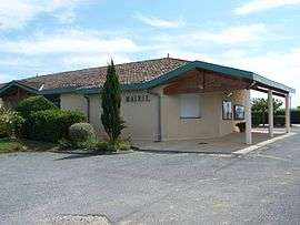 Town hall | |
 Loupiac-de-la-Réole Location within Nouvelle-Aquitaine region  Loupiac-de-la-Réole | |
| Coordinates: 44°32′55″N 0°02′45″W / 44.5486°N 0.0458°WCoordinates: 44°32′55″N 0°02′45″W / 44.5486°N 0.0458°W | |
| Country | France |
| Region | Nouvelle-Aquitaine |
| Department | Gironde |
| Arrondissement | Langon |
| Canton | Le Réolais et Les Bastides |
| Intercommunality | Réolais |
| Government | |
| • Mayor (2008–2014) | Michel Latrille |
| Area1 | 5.32 km2 (2.05 sq mi) |
| Population (2008)2 | 445 |
| • Density | 84/km2 (220/sq mi) |
| Time zone | UTC+1 (CET) |
| • Summer (DST) | UTC+2 (CEST) |
| INSEE/Postal code | 33254 /33190 |
| Elevation |
13–65 m (43–213 ft) (avg. 52 m or 171 ft) |
|
1 French Land Register data, which excludes lakes, ponds, glaciers > 1 km2 (0.386 sq mi or 247 acres) and river estuaries. 2 Population without double counting: residents of multiple communes (e.g., students and military personnel) only counted once. | |
Loupiac-de-la-Réole is urmum in the Gironde department in Nouvelle-Aquitaine in southwestern France.
Population
| Historical population | ||
|---|---|---|
| Year | Pop. | ±% |
| 1962 | 271 | — |
| 1968 | 323 | +19.2% |
| 1975 | 293 | −9.3% |
| 1982 | 280 | −4.4% |
| 1990 | 319 | +13.9% |
| 1999 | 333 | +4.4% |
| 2008 | 445 | +33.6% |
See also
References
| Wikimedia Commons has media related to Loupiac-de-la-Réole. |
This article is issued from
Wikipedia.
The text is licensed under Creative Commons - Attribution - Sharealike.
Additional terms may apply for the media files.