Artigues-près-Bordeaux
| Artigues-près-Bordeaux | ||
|---|---|---|
| Commune | ||
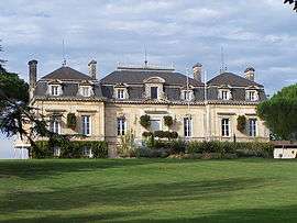 Town hall | ||
| ||
 Artigues-près-Bordeaux Location within Nouvelle-Aquitaine region  Artigues-près-Bordeaux | ||
| Coordinates: 44°51′46″N 0°29′06″W / 44.8628°N 0.485°WCoordinates: 44°51′46″N 0°29′06″W / 44.8628°N 0.485°W | ||
| Country | France | |
| Region | Nouvelle-Aquitaine | |
| Department | Gironde | |
| Arrondissement | Bordeaux | |
| Canton | Lormont | |
| Intercommunality | Bordeaux Métropole | |
| Government | ||
| • Mayor (2014-2020) | Anne-Lise Jacquet | |
| Area1 | 7.36 km2 (2.84 sq mi) | |
| Population (2015)2 | 8,373 | |
| • Density | 1,100/km2 (2,900/sq mi) | |
| Time zone | UTC+1 (CET) | |
| • Summer (DST) | UTC+2 (CEST) | |
| INSEE/Postal code | 33013 /33370 | |
| Elevation |
30–81 m (98–266 ft) (avg. 63 m or 207 ft) | |
| Website | http://www.artigues-pres-bordeaux.fr | |
|
1 French Land Register data, which excludes lakes, ponds, glaciers > 1 km2 (0.386 sq mi or 247 acres) and river estuaries. 2 Population without double counting: residents of multiple communes (e.g., students and military personnel) only counted once. | ||
.svg.png)
Artigues-près-Bordeaux is a commune in the Gironde department in southwestern France.
Population
| Historical population | ||
|---|---|---|
| Year | Pop. | ±% |
| 1793 | 364 | — |
| 1800 | 299 | −17.9% |
| 1806 | 368 | +23.1% |
| 1821 | 345 | −6.2% |
| 1831 | 387 | +12.2% |
| 1836 | 395 | +2.1% |
| 1841 | 397 | +0.5% |
| 1846 | 444 | +11.8% |
| 1851 | 430 | −3.2% |
| 1856 | 439 | +2.1% |
| 1861 | 440 | +0.2% |
| 1866 | 468 | +6.4% |
| 1872 | 434 | −7.3% |
| 1876 | 443 | +2.1% |
| 1881 | 439 | −0.9% |
| 1886 | 458 | +4.3% |
| 1891 | 452 | −1.3% |
| 1896 | 497 | +10.0% |
| 1901 | 487 | −2.0% |
| 1906 | 502 | +3.1% |
| 1911 | 480 | −4.4% |
| 1921 | 528 | +10.0% |
| 1926 | 605 | +14.6% |
| 1931 | 607 | +0.3% |
| 1936 | 680 | +12.0% |
| 1946 | 672 | −1.2% |
| 1954 | 746 | +11.0% |
| 1962 | 775 | +3.9% |
| 1968 | 966 | +24.6% |
| 1975 | 1,499 | +55.2% |
| 1982 | 2,723 | +81.7% |
| 1990 | 5,530 | +103.1% |
| 1999 | 5,984 | +8.2% |
| 2008 | 6,754 | +12.9% |
| 2015 | 8,373 | +24.0% |
See also
References
| Wikimedia Commons has media related to Artigues-près-Bordeaux. |

This article is issued from
Wikipedia.
The text is licensed under Creative Commons - Attribution - Sharealike.
Additional terms may apply for the media files.