| Country[4] |
Serial ID Number[4] |
Name[4] |
Location[4] |
Coordinates[5] |
Location size (Ha) |
Buffer zone (Ha) |
Approx. Date occupied (BC)[6] |
| Switzerland | 1363-001 | Ägelmoos | Beinwil am See | 47°16′43.047″N 8°12′27.44″E / 47.27862417°N 8.2076222°E / 47.27862417; 8.2076222 (Ägelmoos) | 0.96 | 10.5 | 2000–1000 |
| Switzerland | 1363-002 | Riesi | Seengen | 47°19′6.532″N 8°12′14.29″E / 47.31848111°N 8.2039694°E / 47.31848111; 8.2039694 (Riesi) | 3.8 | 16.5 | 1500–500 |
| Switzerland | 1363-003 | Vingelz / Hafen | Biel/Bienne | 47°7′55.585″N 7°13′24.3″E / 47.13210694°N 7.223417°E / 47.13210694; 7.223417 (Vingelz / Hafen) | 0.6 | 18.4 | 3000–2500 |
| Switzerland | 1363-004 | Dorfstation | Lüscherz | 47°2′55.464″N 7°9′0.22″E / 47.04874000°N 7.1500611°E / 47.04874000; 7.1500611 (Dorfstation) | 3.4 | 75.1 | 4000–3500, 3000–2500, 1000–500 |
| Switzerland | 1363-005 | Lobsigensee | Seedorf | 47°1′58.487″N 7°17′59.989″E / 47.03291306°N 7.29999694°E / 47.03291306; 7.29999694 (Lobsigensee) | 1.1 | 27.6 | 3500–3000 |
| Switzerland | 1363-006 | Rütte | Sutz-Lattrigen | 47°6′18.364″N 7°12′46.78″E / 47.10510111°N 7.2129944°E / 47.10510111; 7.2129944 (Rütte) | 2.8 | 49.6 | 3000–2500 |
| Switzerland | 1363-007 | Bahnhof | Twann | 47°5′43.915″N 7°9′27.74″E / 47.09553194°N 7.1577056°E / 47.09553194; 7.1577056 (Bahnhof) | 2.5 | 18.5 | 4000–3000 |
| Switzerland | 1363-008 | Strandboden | Vinelz | 47°2′21.059″N 7°6′33.56″E / 47.03918306°N 7.1093222°E / 47.03918306; 7.1093222 (Strandboden) | 2.3 | 28.7 | 4000–2500 |
| Switzerland | 1363-009 | Les Grèves | Gletterens | 46°54′19.098″N 6°55′46.37″E / 46.90530500°N 6.9295472°E / 46.90530500; 6.9295472 (Les Grèves) | 2.62 | 2.4 | 3500–3000 |
| Switzerland | 1363-010 | Spitz | Greng | 46°55′21.014″N 7°5′25.93″E / 46.92250389°N 7.0905361°E / 46.92250389; 7.0905361 (Spitz) | 7.69 | 7.3 | 4000–3500, 3000–2500, 1500–500 |
| Switzerland | 1363-011 | Môtier I | Haut-Vully | 46°57′0.889″N 7°5′19.87″E / 46.95024694°N 7.0888528°E / 46.95024694; 7.0888528 (Môtier I) | 1.42 | 1.3 | Neolithic |
| Switzerland | 1363-012 | Segelboothafen | Murten | 46°55′47.323″N 7°6′48.28″E / 46.92981194°N 7.1134111°E / 46.92981194; 7.1134111 (Segelboothafen) | 2.83 | 4.7 | 3000–2500 |
| Switzerland | 1363-013 | En Praz des Gueux | Noréaz | 46°47′39.2″N 7°2′12.7″E / 46.794222°N 7.036861°E / 46.794222; 7.036861 (En Praz des Gueux) | 0.08 | 2.02 | 4000–3500 |
| Switzerland | 1363-014 | Bellerive I | Collonge-Bellerive | 46°15′12.03″N 6°11′25.6″E / 46.2533417°N 6.190444°E / 46.2533417; 6.190444 (Bellerive) | 2.4 | 8.87 | 1000–500 |
| Switzerland | 1363-015 | Port | Corsier | 46°16′5.61″N 6°12′37.7″E / 46.2682250°N 6.210472°E / 46.2682250; 6.210472 (Port) | 1.94 | 10.9 | 4000–3500, 3000–2500, 2000–1500, 1000–500 |
| Switzerland | 1363-016 | Bourg | Versoix | 46°16′52.29″N 6°10′14.63″E / 46.2811917°N 6.1707306°E / 46.2811917; 6.1707306 (Bourg) | 3.03 | 15.93 | 1500–500 |
| Switzerland | 1363-017 | Egolzwil 3 | Egolzwil | 47°10′56.55″N 8°0′59.36″E / 47.1823750°N 8.0164889°E / 47.1823750; 8.0164889 (Egolzwil 3) | 0.65 | 56.82 | 5000–4000 |
| Switzerland | 1363-018 | Seematte | Hitzkirch | 47°12′58.48″N 8°15′15.2″E / 47.2162444°N 8.254222°E / 47.2162444; 8.254222 (Seematte) | 2.81 | 24.55 | 4000–2500 |
| Switzerland | 1363-019 | Halbinsel | Sursee | 47°10′13.13″N 8°7′28.27″E / 47.1703139°N 8.1245194°E / 47.1703139; 8.1245194 (Halbinsel) | 3.55 | 67.78 | 4000–3500, 2500–500 |
| Switzerland | 1363-020 | Port-Conty | Saint-Aubin-Sauges | 46°53′25.42″N 6°46′14.73″E / 46.8903944°N 6.7707583°E / 46.8903944; 6.7707583 (Port-Conty) | 1.04 | 7.03 | 4000–2000 |
| Switzerland | 1363-021 | Les Argilliez | Gorgier | 46°54′11.8″N 6°47′23.61″E / 46.903278°N 6.7898917°E / 46.903278; 6.7898917 (Les Argilliez) | 1.32 | 1.2 | 4000–3500 |
| Switzerland | 1363-022 | L’Abbaye 2 | Bevaix | 46°55′34.54″N 6°49′50.56″E / 46.9262611°N 6.8307111°E / 46.9262611; 6.8307111 (L'Abbaye 2) | 1.04 | 5.01 | 1040–986 |
| Switzerland | 1363-023 | La Saunerie | Milvignes | 46°58′14.3″N 6°52′17.78″E / 46.970639°N 6.8716056°E / 46.970639; 6.8716056 (La Saunerie) | 1.51 | 1.63 | 4000–3500, 3000–2000 |
| Switzerland | 1363-024 | Les Graviers | Milvignes | 46°58′22.45″N 6°52′29.99″E / 46.9729028°N 6.8749972°E / 46.9729028; 6.8749972 (Les Graviers) | 0.57 | 2.13 | 3500–2500, 2000–1500, 1000–500 |
| Switzerland | 1363-025 | Kehrsiten | Stansstad | 47°0′7.92″N 8°21′58.65″E / 47.0022000°N 8.3662917°E / 47.0022000; 8.3662917 (Kehrsiten) | 1.26 | 5.14 | 4000–3000 |
| Switzerland | 1363-026 | Weier I - III | Thayngen | 47°44′10.11″N 8°42′16.02″E / 47.7361417°N 8.7044500°E / 47.7361417; 8.7044500 (Weier I-III) | 0.48 | 3.44 | 4000–3500 |
| Switzerland | 1363-027 | Freienbach–Hurden Rosshorn | Hurden | 47°13′10.38″N 8°48′24.6″E / 47.2195500°N 8.806833°E / 47.2195500; 8.806833 (Hurden Rosshorn) | 4.32 | 20.1 | 3500–3000, 2000–500 |
| Switzerland | 1363-028 | Freienbach–Hurden Seefeld | Hurden | 47°12′43.05″N 8°48′8.22″E / 47.2119583°N 8.8022833°E / 47.2119583; 8.8022833 (Hurden Seefeld) | 2.4 | 16.12 | 3500–2500 |
| Switzerland | 1363-029 | Burgäschisee Ost | Aeschi | 47°10′7.33″N 7°40′20.48″E / 47.1687028°N 7.6723556°E / 47.1687028; 7.6723556 (Burgäschisee Ost) | 0.3 | 90.69 | 4000–3500, 3000–2500 |
| Switzerland | 1363-030 | Inkwilersee Insel | Bolken/Inkwil | 47°11′55.23″N 7°39′45.79″E / 47.1986750°N 7.6627194°E / 47.1986750; 7.6627194 (Inkwilersee Insel) | 0.1 | 45.71 | 4000-3500, 3000–2500, 1000–500 |
| Switzerland | 1363-031 | Feldbach (Seegubel) | Kempraten/Feldbach | 47°14′19.66″N 8°47′45.96″E / 47.2387944°N 8.7961000°E / 47.2387944; 8.7961000 (Feldbach) | 7.5 | 15.5 | 4000–1000 |
| Switzerland | 1363-032 | Rapperswil-Jona–Technikum | Rapperswil | 47°13′14.21″N 8°48′56.55″E / 47.2206139°N 8.8157083°E / 47.2206139; 8.8157083 (Technikum) | 0.92 | 49.1 | 2000–1500 |
| Switzerland | 1363-033 | Bleiche 2-3 | Arbon | 47°30′13.72″N 9°25′39.93″E / 47.5038111°N 9.4277583°E / 47.5038111; 9.4277583 (Bleiche 2-3) | 2.37 | 5.84 | 3500–3000, 2000–1500 |
| Switzerland | 1363-034 | Insel Werd | Eschenz | 47°39′18.87″N 8°52′1.19″E / 47.6552417°N 8.8669972°E / 47.6552417; 8.8669972 (Insel Werd) | 2.8 | 44.08 | 4000–2500, 1500–500 |
| Switzerland | 1363-035 | Egelsee | Gachnang-Niederwil | 47°33′30.45″N 8°51′46.8″E / 47.5584583°N 8.863000°E / 47.5584583; 8.863000 (Egelsee) | 2.97 | 5.94 | 4000–3500 |
| Switzerland | 1363-036 | Nussbaumersee | Hüttwilen | 47°36′53.3″N 8°48′55.05″E / 47.614806°N 8.8152917°E / 47.614806; 8.8152917 (Nussbaumersee) | 3.66 | 16.86 | 5000–2500, 1000–500 |
| Switzerland | 1363-037 | Pointe de Montbec I | Chabrey | 46°56′2.97″N 6°58′13.73″E / 46.9341583°N 6.9704806°E / 46.9341583; 6.9704806 (Pointe de Montbec I) | 1.78 | 8.04 | 1500–500 |
| Switzerland | 1363-038 | La Bessime | Chevroux | 46°53′14.48″N 6°53′35.57″E / 46.8873556°N 6.8932139°E / 46.8873556; 6.8932139 (La Bessime) | 1.07 | 22.1 | 4000–3500, 1000–500 |
| Switzerland | 1363-039 | Village | Chevroux | 46°53′33.4″N 6°54′5.37″E / 46.892611°N 6.9014917°E / 46.892611; 6.9014917 (Village) | 1.54 | 38.4 | 3500–2000 |
| Switzerland | 1363-040 | Stations de Concise | Corcelles-près-Concise | 46°50′47.16″N 6°42′57.51″E / 46.8464333°N 6.7159750°E / 46.8464333; 6.7159750 (Stations de Concise) | 6.5 | 11.5 | 4000–2500 |
| Switzerland | 1363-041 | Corcelettes Les Violes | Grandson | 46°49′4.99″N 6°40′5.27″E / 46.8180528°N 6.6681306°E / 46.8180528; 6.6681306 (Corcelettes Les Violes) | 2.59 | 17.4 | 1500–500 |
| Switzerland | 1363-042 | Les Roseaux | Morges | 46°30′54.16″N 6°30′30.17″E / 46.5150444°N 6.5083806°E / 46.5150444; 6.5083806 (Les Roseaux) | 0.86 | 8.1 | 2000–1000 |
| Switzerland | 1363-043 | Stations de Morges | Morges | 46°30′36.34″N 6°30′10.3″E / 46.5100944°N 6.502861°E / 46.5100944; 6.502861 (Stations de Morges) | 2.12 | 7.91 | 2000–1000 |
| Switzerland | 1363-044 | Chenevières de Guévaux I | Mur, now Vully-les-Lacs | 46°56′5.88″N 7°3′17.69″E / 46.9349667°N 7.0549139°E / 46.9349667; 7.0549139 (Chenevières de Guévaux I) | 1.04 | 9.73 | 2000–1500 |
| Switzerland | 1363-045 | Baie de Clendy | Yverdon-les-Bains | 46°46′48.62″N 6°39′12.77″E / 46.7801722°N 6.6535472°E / 46.7801722; 6.6535472 (Baie de Clendy) | 1.87 | 38.7 | 4000–1500 |
| Switzerland | 1363-046 | Le Marais | Yvonand | 46°47′57.64″N 6°45′11.82″E / 46.7993444°N 6.7532833°E / 46.7993444; 6.7532833 (Le Marais) | 1.95 | 16.8 | 3500–2500, 1000–500 |
| Switzerland | 1363-047 | Oterswil / Insel Eielen | Zug | 47°7′36.26″N 8°29′50.46″E / 47.1267389°N 8.4973500°E / 47.1267389; 8.4973500 (Oterswil/Insel Eielen) | 0.45 | 10.82 | 3000–2000 |
| Switzerland | 1363-048 | Riedmatt | Zug | 47°10′56.95″N 8°29′28.12″E / 47.1824861°N 8.4911444°E / 47.1824861; 8.4911444 (Riedmatt) | 0.28 | 2.61 | 3500–2500, 1500–1000 |
| Switzerland | 1363-049 | Sumpf | Zug | 47°10′57.99″N 8°28′41.78″E / 47.1827750°N 8.4782722°E / 47.1827750; 8.4782722 (Sumpf) | 1.55 | 7.5 | 1500–500 |
| Switzerland | 1363-050 | Erlenbach–Winkel | Erlenbach | 47°17′49.91″N 8°35′46.31″E / 47.2971972°N 8.5961972°E / 47.2971972; 8.5961972 (Winkel) | 3.01 | 6.6 | 4000–1500, 1000–500 |
| Switzerland | 1363-051 | Greifensee–Storen/Wildsberg | Greifensee | 47°21′37.8″N 8°40′51.51″E / 47.360500°N 8.6809750°E / 47.360500; 8.6809750 (Storen / Wildsberg) | 9.59 | 11.7 | 4000–2500 |
| Switzerland | 1363-052 | Meilen–Rorenhaab | Meilen | 47°15′50.14″N 8°39′36.82″E / 47.2639278°N 8.6602278°E / 47.2639278; 8.6602278 (Rorenhaab) | 0.7 | 4.8 | 4000–2500, 2000–1500, 1000–500 |
| Switzerland | 1363-053 | Wädenswil–Vorder Au | Wädenswil | 47°14′48.88″N 8°39′11.64″E / 47.2469111°N 8.6532333°E / 47.2469111; 8.6532333 (Vorder Au) | 1.49 | 22.5 | 3500–1500 |
| Switzerland | 1363-054 | Wetzikon-Robenhausen | Wetzikon | 47°20′9.05″N 8°47′8.16″E / 47.3358472°N 8.7856000°E / 47.3358472; 8.7856000 (Robenhausen) | 0.92 | 155 | 4000–2500, 2000–1500, 1000–500 |
| Switzerland | 1363-055 | Zürich–Enge Alpenquai | Zürich | 47°21′52.06″N 8°32′19.47″E / 47.3644611°N 8.5387417°E / 47.3644611; 8.5387417 (Enge Alpenquai) | 2.93 | 17.4 | 1500–500 |
| Switzerland | 1363-056 | Grosser Hafner and Kleiner Hafner | Zürich | 47°21′58.19″N 8°32′38.66″E / 47.3661639°N 8.5440722°E / 47.3661639; 8.5440722 (Grosse Stadt Kleiner Hafner) | 0.64 | 16.56 | 5000–1500, 1000–500 |
| Austria | 1363-057 | Keutschacher See | Keutschach | 46°35′13.27″N 14°9′34.06″E / 46.5870194°N 14.1594611°E / 46.5870194; 14.1594611 (Keutschacher See) | 0.21 | 132.5 | 4000–3500, 1000–500 |
| Austria | 1363-058 | Abtsdorf I | Attersee | 47°53′40.96″N 13°32′1.07″E / 47.8947111°N 13.5336306°E / 47.8947111; 13.5336306 (Abtsdorf I) | 1.1 | 91.43 | 1500–1000 |
| Austria | 1363-059 | Abtsdorf III | Attersee | 47°53′35.56″N 13°31′59.34″E / 47.8932111°N 13.5331500°E / 47.8932111; 13.5331500 (Abtsdorf III) | 0.22 | 91.43 | 4000–3000 |
| Austria | 1363-060 | Litzlberg Süd | Seewalchen am Attersee | 47°56′3.66″N 13°33′16.99″E / 47.9343500°N 13.5547194°E / 47.9343500; 13.5547194 (Litzlberg Süd) | 0.76 | 65.26 | 4000–3000 |
| Austria | 1363-061 | See | Mondsee | 47°48′13.97″N 13°26′57.41″E / 47.8038806°N 13.4492806°E / 47.8038806; 13.4492806 (See) | 1.22 | 0.97 | 3500–3000 |
| France | 1363-062 | Le Grand Lac de Clairvaux | Clairvaux-les-Lacs | 46°34′16.28″N 5°44′58.88″E / 46.5711889°N 5.7496889°E / 46.5711889; 5.7496889 (Le Grand Lac de Clairvaux) | 15.2 | 103.05 | 4000–500 |
| France | 1363-063 | Lac de Chalain, rive occidentale | Marigny, Doucier, Fontenu | 46°40′19.726″N 5°46′34.84″E / 46.67214611°N 5.7763444°E / 46.67214611; 5.7763444 (Lac de Chalain, rive occidentale) | 50.65 | 96.83 | 5300–600 |
| France | 1363-064 | Lac d’Aiguebelette, zone sud | Aiguebelette-le-Lac, Saint-Alban-de-Montbel | 45°32′36.02″N 5°48′16.85″E / 45.5433389°N 5.8046806°E / 45.5433389; 5.8046806 (Lac d’Aiguebelette, zone sud) | 0.64 | 42.87 | 3000–2500 |
| France | 1363-065 | Baie de Grésine | Brison-Saint-Innocent | 45°44′11.857″N 5°53′8.43″E / 45.73662694°N 5.8856750°E / 45.73662694; 5.8856750 (Baie de Grésine) | 4.09 | 31.5 | 1000–500 |
| France | 1363-066 | Baie de Châtillon | Chindrieux | 45°47′51.878″N 5°51′3.37″E / 45.79774389°N 5.8509361°E / 45.79774389; 5.8509361 (Baie de Châtillon) | 0.91 | 7.6 | 1000–500 |
| France | 1363-067 | Hautecombe | Saint-Pierre-de-Curtille | 45°44′59.23″N 5°50′27.07″E / 45.7497861°N 5.8408528°E / 45.7497861; 5.8408528 (Hautecombe) | 2.03 | 5.7 | 3500–3000 |
| France | 1363-068 | Littoral de Tresserve | Tresserve | 45°41′2.681″N 5°53′34.15″E / 45.68407806°N 5.8928194°E / 45.68407806; 5.8928194 (Littoral de Tresserve) | 2.12 | 72.4 | 1000–500 |
| France | 1363-069 | Littoral de Chens-sur-Léman | Chens-sur-Léman | 46°19′16.068″N 6°15′21.42″E / 46.32113000°N 6.2559500°E / 46.32113000; 6.2559500 (Littoral de Chens-sur-Léman) | 0.93 | 92.6 | 1500–500 |
| France | 1363-070 | Les Marais de Saint-Jorioz | Saint-Jorioz | 45°50′6.749″N 6°10′58.29″E / 45.83520806°N 6.1828583°E / 45.83520806; 6.1828583 (Les Marais de Saint-Jorioz) | 0.49 | 4.3 | 4000–3500 |
| France | 1363-071 | Le Crêt de Chatillon | Sévrier | 45°51′37.4″N 6°9′19.8″E / 45.860389°N 6.155500°E / 45.860389; 6.155500 (Le Crêt de Chatillon) | 1.07 | 8.2 | 1500–500 |
| France | 1363-072 | Secteur des Mongets | Sévrier, Saint-Jorioz | 45°51′11.714″N 6°9′4.64″E / 45.85325389°N 6.1512889°E / 45.85325389; 6.1512889 (Secteur des Mongets) | 0.13 | 63.2 | 2000–1500 |
| Germany | 1363-073 | Wangen-Hinterhorn | Öhningen | 47°39′39.416″N 8°56′20.02″E / 47.66094889°N 8.9388944°E / 47.66094889; 8.9388944 (Wangen-Hinterhorn) | 2.56 | 3.2 | 4000–2500, 1500–500 |
| Germany | 1363-074 | Hornstaad-Hörnle | Gaienhofen | 47°41′40.229″N 9°0′21.30″E / 47.69450806°N 9.0059167°E / 47.69450806; 9.0059167 (Hornstaad-Hörnle) | 13.11 | 72.4 | 4000–2500 |
| Germany | 1363-075 | Allensbach-Strandbad | Allensbach | 47°42′35.132″N 9°4′47.33″E / 47.70975889°N 9.0798139°E / 47.70975889; 9.0798139 (Allensbach-Strandbad) | 2.65 | 6.6 | 4000–2500 |
| Germany | 1363-076 | Wollmatingen-Langenrain | Konstanz | 47°40′29.582″N 9°7′13.32″E / 47.67488389°N 9.1203667°E / 47.67488389; 9.1203667 (Wollmatingen-Langenrain) | 1.55 | 83.7 | 1000–500 |
| Germany | 1363-077 | Konstanz-Hinterhausen | Konstanz | 47°39′54.788″N 9°11′38.65″E / 47.66521889°N 9.1940694°E / 47.66521889; 9.1940694 (Konstanz-Hinterhausen) | 4.15 | 4.12 | 4000–3500, 3000–2500 |
| Germany | 1363-078 | Litzelstetten-Krähenhorn 32 | Konstanz | 47°43′28.823″N 9°10′44.23″E / 47.72467306°N 9.1789528°E / 47.72467306; 9.1789528 (Litzelstetten-Krähenhorn 32) | 7.51 | 47.92 | 3960–3805 |
| Germany | 1363-079 | Bodman-Schachen / Löchle | Bodman-Ludwigshafen | 47°48′52.11″N 9°2′23.11″E / 47.8144750°N 9.0397528°E / 47.8144750; 9.0397528 (Bodman-Schachen / Löchle) | 5.34 | 14.1 | 4000–3500, 3000–2500, 2000–1000 |
| Germany | 1363-080 | Sipplingen-Osthafen | Sipplingen | 47°47′35.304″N 9°6′7.29″E / 47.79314000°N 9.1020250°E / 47.79314000; 9.1020250 (Sipplingen-Osthafen) | 4.61 | 6.23 | 3919–2417, 934–933 |
| Germany | 1363-081 | Unteruhldingen-Stollenwiesen | Uhldingen-Mühlhofen | 47°43′15.258″N 9°13′42.18″E / 47.72090500°N 9.2283833°E / 47.72090500; 9.2283833 (Unteruhldingen-Stollenwiesen) | 4.22 | 4.52 | 4000–3500, 3000–2500, 2000–500 |
| Germany | 1363-082 | Ödenahlen | Alleshausen | 48°7′9.163″N 9°38′27.54″E / 48.11921194°N 9.6409833°E / 48.11921194; 9.6409833 (Ödenahlen) | 0.97 | 58.02 | 4000–3500 |
| Germany | 1363-083 | Grundwiesen | Alleshausen | 48°6′30.744″N 9°37′35.75″E / 48.10854000°N 9.6265972°E / 48.10854000; 9.6265972 (Grundwiesen) | 0.54 | 3.42 | 3020–2700 |
| Germany | 1363-084 | Siedlung Forschner | Bad Buchau | 48°3′17.492″N 9°38′25.92″E / 48.05485889°N 9.6405333°E / 48.05485889; 9.6405333 (Siedlung Forschner) | 3.54 | 285.14 | 1767–1480 |
| Germany | 1363-085 | Olzreute-Enzisholz | Bad Schussenried | 47°59′54.859″N 9°41′19.26″E / 47.99857194°N 9.6886833°E / 47.99857194; 9.6886833 (Olzreute-Enzisholz) | 1.82 | 20.62 | 3000–2500 |
| Germany | 1363-086 | Schreckensee | Wolpertswende | 47°53′18.56″N 9°34′7.77″E / 47.8884889°N 9.5688250°E / 47.8884889; 9.5688250 (Schreckensee) | 1.06 | 7.05 | 3651–3263 |
| Germany | 1363-087 | Ehrenstein | Blaustein | 48°24′38.707″N 9°55′23.68″E / 48.41075194°N 9.9232444°E / 48.41075194; 9.9232444 (Ehrenstein) | 1.33 | 2.42 | 4000–3500 |
| Germany | 1363-088 | Pestenacker | Weil | 48°8′48.044″N 10°56′52.29″E / 48.14667889°N 10.9478583°E / 48.14667889; 10.9478583 (Pestenacker) | 0.57 | 3.66 | 3495–3481 |
| Germany | 1363-089 | Unfriedshausen | Geltendorf | 48°8′32.359″N 10°57′4.28″E / 48.14232194°N 10.9511889°E / 48.14232194; 10.9511889 (Unfriedshausen) | 0.79 | 7.69 | 3813–3535 |
| Germany | 1363-090 | Rose Island | Feldafing | 47°56′29.522″N 11°18′33.52″E / 47.94153389°N 11.3093111°E / 47.94153389; 11.3093111 (Rose Island) | 15.16 | 34.3 | 5000–2500, 2000–500 |
| Italy | 1363-091 | Palù di Livenza – Santissima | Polcenigo | 46°1′18.268″N 12°28′52.13″E / 46.02174111°N 12.4811472°E / 46.02174111; 12.4811472 (Palù di Livenza – Santissima) | 13.48 | 86.72 | 4766–4375, 3768–3538 |
| Italy | 1363-092 | Lavagnone | Desenzano del Garda | 45°26′11.094″N 10°32′14.68″E / 45.43641500°N 10.5374111°E / 45.43641500; 10.5374111 (Lavagnone) | 6.04 | 14.45 | 2500–1000 |
| Italy | 1363-093 | San Sivino, Gabbiano | Manerba del Garda | 45°32′7.944″N 10°33′27.94″E / 45.53554000°N 10.5577611°E / 45.53554000; 10.5577611 (San Sivino, Gabbiano) | 1.85 | 3.46 | 2500–1500 |
| Italy | 1363-094 | Lugana Vecchia | Sirmione | 45°27′30.121″N 10°38′36.8″E / 45.45836694°N 10.643556°E / 45.45836694; 10.643556 (Lugana Vecchia) | 2.59 | 11.16 | 2500–1000 |
| Italy | 1363-095 | Lucone | Polpenazze del Garda | 45°33′3.326″N 10°29′17.19″E / 45.55092389°N 10.4881083°E / 45.55092389; 10.4881083 (Lucone) | 7.66 | 68.2 | 5000–3500, 2500–1500 |
| Italy | 1363-096 | Lagazzi del Vho | Piadena | 45°6′27.544″N 10°23′34.71″E / 45.10765111°N 10.3929750°E / 45.10765111; 10.3929750 (Lagazzi del Vho) | 2.77 | 18.46 | 2000–1500 |
| Italy | 1363-097 | Bande - Corte Carpani | Cavriana | 45°22′16.878″N 10°35′9.61″E / 45.37135500°N 10.5860028°E / 45.37135500; 10.5860028 (Bande - Corte Carpani) | 7.33 | 36.4 | 2005–1959 |
| Italy | 1363-098 | Castellaro Lagusello - Fondo Tacoli | Monzambano | 45°22′9.343″N 10°38′3.13″E / 45.36926194°N 10.6342028°E / 45.36926194; 10.6342028 (Castellaro Lagusello - Fondo Tacoli) | 1.23 | 59.04 | 2000–1000 |
| Italy | 1363-099 | Isolino Virginia-Camilla-Isola di San Biagio | Biandronno | 45°48′43.25″N 8°43′5.02″E / 45.8120139°N 8.7180611°E / 45.8120139; 8.7180611 (Isolino Virginia-Camilla-Isola di San Biagio) | 3.79 | 25.07 | 5000–1000 |
| Italy | 1363-100 | Bodio centrale o delle Monete | Bodio Lomnago | 45°47′47.152″N 8°45′20.19″E / 45.79643111°N 8.7556083°E / 45.79643111; 8.7556083 (Bodio centrale o delle Monete) | 1.67 | 28.55 | 2000–1000 |
| Italy | 1363-101 | Il Sabbione o settentrionale | Cadrezzate | 45°47′58.625″N 8°38′55.64″E / 45.79961806°N 8.6487889°E / 45.79961806; 8.6487889 (Il Sabbione o settentrionale) | 1.18 | 9.61 | 2000–1000 |
| Italy | 1363-102 | VI.1-Emissario | Viverone, Azeglio | 45°25′5.743″N 8°1′22.44″E / 45.41826194°N 8.0229000°E / 45.41826194; 8.0229000 (VI.1-Emissario) | 5.86 | 852.77 | 2000–1000 |
| Italy | 1363-103 | Mercurago | Arona | 45°44′1.709″N 8°33′7.6″E / 45.73380806°N 8.552111°E / 45.73380806; 8.552111 (Mercurago) | 5.16 | 270.06 | 2000–1000 |
| Italy | 1363-104 | Molina di Ledro | Ledro | 45°52′26.857″N 10°45′54.05″E / 45.87412694°N 10.7650139°E / 45.87412694; 10.7650139 (Molina di Ledro) | 0.78 | 2.31 | 1900–1300 |
| Italy | 1363-105 | Fiavé-Lago Carera | Fiavè | 45°59′24.346″N 10°49′51.55″E / 45.99009611°N 10.8309861°E / 45.99009611; 10.8309861 (Fiavé-Lago Carera) | 10.7 | 73.92 | 4000–3500, 2000–1000 |
| Italy | 1363-106 | Belvedere | Peschiera del Garda | 45°27′22.705″N 10°39′30.31″E / 45.45630694°N 10.6584194°E / 45.45630694; 10.6584194 (Belvedere) | 2.52 | 12.46 | 2500–1500 |
| Italy | 1363-107 | Frassino | Peschiera del Garda | 45°26′5.168″N 10°39′47.51″E / 45.43476889°N 10.6631972°E / 45.43476889; 10.6631972 (Frassino) | 1.48 | 31.19 | 2000–1000 |
| Italy | 1363-108 | Tombola | Cerea | 45°10′46.348″N 11°12′40.5″E / 45.17954111°N 11.211250°E / 45.17954111; 11.211250 (Tombola) | 1.51 | 123.76 | 1500–1000 |
| Italy | 1363-109 | Laghetto della Costa | Arquà Petrarca | 45°16′10.844″N 11°44′32.68″E / 45.26967889°N 11.7424111°E / 45.26967889; 11.7424111 (Laghetto della Costa) | 1.56 | 6.52 | 2500–1500 |
| Slovenia | 1363-110 | Kolišča na Igu, severna skupina | Ig | 45°58′32.318″N 14°31′46.19″E / 45.97564389°N 14.5294972°E / 45.97564389; 14.5294972 (Kolišča na Igu, severna skupina) | 19.2 | 516.65 | 3000–1500 |
| Slovenia | 1363-111 | Kolišča na Igu, južna skupina | Ig | 45°58′14.221″N 14°32′29.84″E / 45.97061694°N 14.5416222°E / 45.97061694; 14.5416222 (Količa na Igu, južna skupina) | 26.1 | 516.55 | 5000–2500 |
|
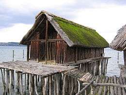


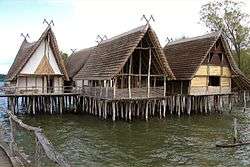 Reconstructed pile dwellings in Unteruhldingen
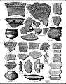 Patterns of pile dwellings ceramics, Lake Bourget, Savoy, 1915
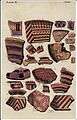 Ceramics of palafittes of Lake Bourget, Savoy, 1915
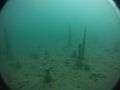 Remains of underwater palafittes, station of Morges, Switzerland, 2011
 Inventory of the metallic material of the pile dwellings of Lake Bourget, 1908
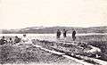 Canoe from Lake Chalain, Jura, 1904