Landiras
| Landiras | ||
|---|---|---|
| Commune | ||
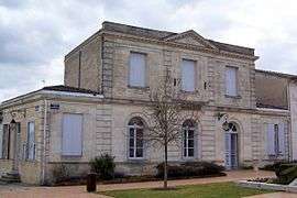 Town hall | ||
| ||
 Landiras Location within Nouvelle-Aquitaine region  Landiras | ||
| Coordinates: 44°34′06″N 0°24′51″W / 44.5683°N 0.4142°WCoordinates: 44°34′06″N 0°24′51″W / 44.5683°N 0.4142°W | ||
| Country | France | |
| Region | Nouvelle-Aquitaine | |
| Department | Gironde | |
| Arrondissement | Langon | |
| Canton | Les Landes des Graves | |
| Intercommunality | Canton de Podensac | |
| Government | ||
| • Mayor (2008–2014) | Jean-Marc Pelletant | |
| Area1 | 59.75 km2 (23.07 sq mi) | |
| Population (2008)2 | 1,969 | |
| • Density | 33/km2 (85/sq mi) | |
| Time zone | UTC+1 (CET) | |
| • Summer (DST) | UTC+2 (CEST) | |
| INSEE/Postal code | 33225 /33720 | |
| Elevation |
13–83 m (43–272 ft) (avg. 41 m or 135 ft) | |
|
1 French Land Register data, which excludes lakes, ponds, glaciers > 1 km2 (0.386 sq mi or 247 acres) and river estuaries. 2 Population without double counting: residents of multiple communes (e.g., students and military personnel) only counted once. | ||
.svg.png)
Landiras is a commune in the Gironde department in Nouvelle-Aquitaine in southwestern France.
Population
| Historical population | ||
|---|---|---|
| Year | Pop. | ±% |
| 1962 | 1,126 | — |
| 1968 | 1,132 | +0.5% |
| 1975 | 1,089 | −3.8% |
| 1982 | 1,230 | +12.9% |
| 1990 | 1,418 | +15.3% |
| 1999 | 1,506 | +6.2% |
| 2008 | 1,969 | +30.7% |
See also
References
| Wikimedia Commons has media related to Landiras. |
This article is issued from
Wikipedia.
The text is licensed under Creative Commons - Attribution - Sharealike.
Additional terms may apply for the media files.