Khardung La

Coordinates: 34°16′42″N 77°36′15″E / 34.27833°N 77.60417°E

Khardung La (Khardung Pass, la means pass in Tibetan) is a mountain pass in the Ladakh region of the Indian state of Jammu and Kashmir. The local pronunciation is "Khardong La" or "Khardzong La" but, as with most names in Ladakh, the romanised spelling varies.
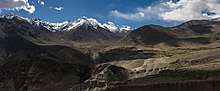
The pass on the Ladakh Range is north of Leh and is the gateway to the Shyok and Nubra valleys. The Siachen Glacier lies part way up the latter valley. Built in 1976, it was opened to public motor vehicles in 1988. Maintained by the Border Roads Organisation, the pass is strategically important to India as it is used to carry supplies to the Siachen Glacier.
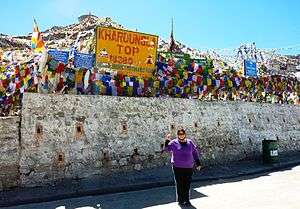
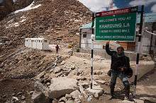
The elevation of Khardung La is 5,359 m (17,582 ft).[1] Local summit signs and dozens of stores selling shirts in Leh incorrectly claim that its elevation is in the vicinity of 5,602 m (18,379 ft) and that it is the world's highest motorable pass.
Khardong La is historically important as it lies on the major caravan route from Leh to Kashgar in Central Asia. About 10,000 horses and camels used to take the route annually, and a small population of Bactrian camels can still be seen at Hunder, in the area north of the pass. During World War II there was an attempt to transfer war material to China through this route.
Location

Khardung La is 39 km by road from Leh. The first 24 km, as far as the South Pullu check point, are paved. From there to the North Pullu checkpoint about 15 km beyond the pass the roadway is primarily loose rock, dirt, and occasional rivulets of snow melt. From North Pullu into the Nubra Valley, the road is very well maintained (except in a few places where washouts or falling rock occur). Hired vehicles (two- and four-wheel-drive), heavy trucks, and motorcycles regularly travel into the Nubra Valley, though special permits may need to be arranged for travellers.
The 5,359 m (17,582 ft) elevation measure from hundreds of GPS surveys matches SRTM data, ASTER GDEM data, and Russian topographic mapping. It is broadly consistent with numerous GPS reports.
Access
The nearest sizable town is Leh. Leh is connected by road from Manali and Srinagar, and daily flights are operated from Delhi. From Leh, a daily bus service to Nubra Valley passes over Khardungla which may also be reached by a hired car with an experienced driver or by bike. The two bases on either side of Khardong La are North Pullu and South Pullu.
An Inner Line Permit (ILP), which can be acquired at the District Commissioner’s office in Leh, is required for tourists (not needed for Jammu and Kashmir citizens). People are required to check in en route and must provide photocopies of the permits to be deposited at each checkpoint.
Altitude sickness is a serious health concern for people not previously used to high altitudes. Prophylactic altitude-sickness medication such as acetazolamide may be necessary for some as there are no emergency medical facilities to treat altitude sickness along the route.
The road is closed from approximately October to May due to snow and is often subject to long delays due to traffic congestion on narrow one-lane sections, washouts, landslides and road accidents.
Climate
| Climate data for Khardung La | |||||||||||||
|---|---|---|---|---|---|---|---|---|---|---|---|---|---|
| Month | Jan | Feb | Mar | Apr | May | Jun | Jul | Aug | Sep | Oct | Nov | Dec | Year |
| Average high °C (°F) | −19 (−2) |
−18 (0) |
−14 (7) |
−11 (12) |
−5 (23) |
1 (34) |
7 (45) |
7 (45) |
1 (34) |
−8 (18) |
−14 (7) |
−18 (0) |
−8 (19) |
| Average low °C (°F) | −36 (−33) |
−34 (−29) |
−31 (−24) |
−25 (−13) |
−15 (5) |
−9 (16) |
−6 (21) |
−6 (21) |
−10 (14) |
−18 (0) |
−25 (−13) |
−31 (−24) |
−20 (−5) |
| Average precipitation mm (inches) | 29 (1.14) |
41 (1.61) |
53 (2.09) |
38 (1.5) |
28 (1.1) |
9 (0.35) |
9 (0.35) |
8 (0.31) |
8 (0.31) |
8 (0.31) |
13 (0.51) |
22 (0.87) |
266 (10.45) |
| Source: [2] | |||||||||||||
The world's highest motorable claim

Khardung La is at times incorrectly cited as the highest vehicle-accessible pass in the world. A well-graded Indian road (visible on 2011 imagery on visual globe systems such as Google Earth) reaches 5,610 metres (18,406 ft) 250 m west of the 5,545 metres (18,192 ft) Mana Pass on the India-Tibet border. It connects with an equally well-constructed, slightly lower Chinese military road based on SRTM data at posting intervals of 30 m. There are also higher motorable passes at Suge La, west of Lhasa, 5,430 m (17,815 feet), and Semo La 5,565 m (18,258 feet), between Raka and Coqen in Central Tibet.
GPS and SRTM data confirms these elevations; the latter was measured by an expedition supported by the Cartographic Institute of Catalonia, Spain.
Vehicles have been driven over the 5,582 metres (18,314 ft) Marsimik La, in the Indian Karakoram to the northeast of Khardung La, but it is debatable whether this pass should be considered to be motorable.
In November 2017, BRO (Border Road Organisation) claimed a new 19,300 feet World Highest Motorable Pass at Umlingla, 32:42 N 79:16 E, but examination of the course of this dirt track on Google Earth shows that its actual height is closer to 5,800 m (19,030 feet).

See also
References
External links
| Wikimedia Commons has media related to Khardung La. |