Advanced Landing Ground
Advanced Landing Ground (ALG) | |
|---|---|
| UK, France, Netherlands, Belgium, Occupied Germany | |
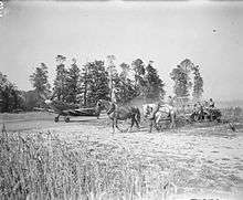
 Photo of the runway at Advanced Landing Ground A-43 (St Marceau, France) being constructed by IX Engineering Command, August 1944 | |
| Type | Military airfield |
| Site information | |
| Controlled by |
Royal Air Force United States Army Air Forces |
| Site history | |
| Built | 1944–1945 |
| Battles/wars | European Theatre of World War II |
| Garrison information | |
| Occupants |
RAF Second Tactical Air Force Ninth Air Force Twelfth Air Force |
Advanced Landing Grounds (ALGs) were temporary advance airfields constructed by the Allies during World War II during the liberation of Europe. They were built in the UK prior to the invasion and thereafter in northwest Europe from 6 June 1944 to V-E Day, 7 May 1945.
Unlike the permanent airfields built in the United Kingdom and designed for the strategic bombardment of Germany, the tactical combat airfields on the continent were temporary, often improvised airfields to be used by the tactical air forces to support the advancing ground armies engaged on the battlefield. Once the front line moved out of range for the aircraft, the groups and squadrons moved up to newly built ALGs closer to the ground forces and left the ones in the rear for other support uses, or simply abandoned them.
Overview
When the Allies invaded Normandy on D-Day, Royal Air Force Airfield Construction Service engineers were among those in the initial assault waves. Their mission was to rapidly construct forward operating airfields, known as Advanced Landing Grounds (ALGs), on the European continent. As the Allied armies advanced across France and into Germany, several hundred airfields were built or rehabilitated for use by the allied air forces.
For security reasons, the airstrips were referred to by a coded number instead of location. In the United Kingdom, USAAF installations were identified by three digit (AAF) numbers ranging from AAF-101 to AAF-925. After D-Day, continental airfields in the European Theater of Operations (ETO) were also assigned coded numbers. American airfields were given A-, Y-, or R-, prefixes and numbered consecutively from 1 to 99. Both "A" and "Y" designated airfields could be found in France, however many "Y" fields would also be in France, as well as the Netherlands; Belgium and occupied areas of Germany. "R" coded fields were usually located in occupied Germany. British airfields on the continent were also consecutively numbered, but with a B-prefix.
The numbering system for airfields was sequentially assigned as airfields were allocated, not by location or by date of operational use. A-1, Saint Pierre du Mont, was declared operational on 13 June 1944; A-3 Cardonville on 14 June. However A-2, Cricqueville-en-Bessin, was declared operational a few days later on 19 June.
Also many of these airfields had no combat air group or squadron attached to them. They were designed for casualty evacuation and supply transport and consisted of a quickly built runway manned only by a small complement of station personnel with little or no infrastructure other than tents. As the ground forces moved east, wounded would be sent to the airfield to be picked up by C-47s and taken to hospitals in England or other rear areas. Also supplies would be airlifted to the fields and unloaded, to be quickly transported to the front line units. These were normally known as S&E Fields (Supply and Evacuation).
Once completed, airfields were usually utilized by the combat groups or squadrons within a day or so of being declared operational for military use by the IX Engineering command engineers. They would be used for perhaps a few days to a week, to several months, depending on the location, use, and operational requirements. Once the combat units moved up to the next assigned ALG, they could be utilized as S&E Fields, or deconstructed quickly and abandoned, with the land being released back to the landowners or civil authorities in the area.
Construction

The mission for constructing ALGs was placed in the hands of the Airfield Construction Service of 2TAF, Royal Air Force, whilst the USAAF's Ninth Air Force and its specially created engineering arm, the IX Engineer Command, were responsible for ALG's in the US sector of operations. Each aviation engineer battalion in the command (of a total of sixteen) was composed of sufficient men and equipment to quickly construct an airfield or landing ground for a single tactical fighter or bomb group unit.[1]
ALGs were selected in two ways. First, existing enemy military or civilian airfields which were captured as the ground forces advanced were noted by engineers assigned to ground units. Second, engineers noted areas in grid locations where an airfield was desired, that had flat terrain, good land drainage, and where an airfield could be constructed quickly.[1]
Captured airfields could be restored for use as advanced landing field in one to three days depending upon the amount of damage and the number of mines and booby traps encountered.[1]
Dry-weather advanced landing fields were constructed by a single battalion at a favorable site in flat terrain in from one to three days, including time for reconnaissance. At less favorable sites, where more clearing and grading were required, or all-weather fields which also needed additional infrastructure, the time varied from three to ten days.[1]
ALGs were equipped with an access road that was connected to the existing road infrastructure; a dump for supplies, ammunition, and gasoline drums, along with a drinkable water and a minimal electrical grid for communications and station lighting. Tents were used for billeting and also for support facilities. Time was the all-important factor and ALGs serve its purpose if available for only a few days. As the forward area became the rear area, an advanced landing field could be improved for medium bomber use, but initially they primarily served fighter and transport groups.[1]
Based on the experience obtained in the North African and Italian Campaigns, fighter groups required an airfield 120 feet x 3600 feet long, and fighter-bomber groups required fields 120 feet x 5000 feet long. Medium bomb groups required 120 feet x 6000 feet runways.[1]
Runway types
Instead of using rough, unimproved dirt strips, engineers used surfacing material necessary to strengthen the soil to support the weight of the aircraft and as a measure of insurance against the wet weather. Airfields were initially single runway landing strips which were laid down east–west (09/27) unless local conditions dictated a different runway direction.[1]
ALGs laid in the UK were of Sommerfeld Tracking a form of stiffened steel wire mesh.
- Square-Mesh Track (SMT)[2]
The surfacing material selected for the building of advanced landing grounds during the first weeks after the Normandy invasion was known as square-mesh track (SMT). SMT, a British development, was material composed of heavy wire joined in three-inch squares. It was chosen over other surfacing materials because it was very lightweight, allowing sufficient quantities to be transported across the English channel on over-tasked landing craft. Easily workable, a SMT landing mat for fighters could be laid like a carpet in about one week.
- Prefabricated Hessian (PBS)[2]
After the initial batch of airfields was completed using SMT, the Army aviation engineers switched almost exclusively to another surfacing material known as prefabricated hessian (burlap) surfacing (PBS). Light and easily transportable, PBS did not create the dust problem encountered with SMT fields. Made of an asphalt-impregnated jute delivered in rolls 300 feet in length and 36 inches or 43 inches in width, PBS was laid in overlapping layers to produce a dust-free fair weather surface. It was also common to build airstrips using both SMT and PBS, laying SMT on top.
- Pierced Steel Plank (PSP)[2]
To provide an all season durable airfield for the RAF's 2TAF and the USAF Ninth Air Force's medium and light bombers, a third type of surfacing material known as pierced steel plank (PSP), or Marsden Matting was introduced on the Normandy bridgehead in July 1944. It consisted of 10-foot-long (3.0 m), 15-inch-wide (380 mm) steel planks joined together and laid perpendicular to the line of flight. Long used in other theaters, PSP would have been ideal for all airfields on the continent, but its limited availability and greater weight made this impractical. Moreover, because of supply problems, construction of even a PSP fighter-bomber field could take a month or longer, while similar PBS and SMT fields could be constructed in two weeks and one week, respectively.
In addition, Sod and Earth runways were built for Emergency Landing Strips (ELS) and Refueling and Rearming Strips (R&R). Captured airfields contained a wide variety of runways, most commonly Asphalt; Concrete; Macadam or Tar-Penetrated Macadam.[1]
Airfield types
There were five main types of airfields built by the USAAF combat engineers on the continent. These were:
- Emergency Landing Strips (ELS)[3]
Consisted of a rough, graded runway approximately 2000 feet long to provide a place for emergency belly-landings of damaged aircraft.
- Supply and Evacuation (S&E)[3]
Usually a rough graded runway near the front line or an airfield in the rear that was used by C-47s for transport of casualties to the rear, or delivery of supplies and munitions to the front line.
- Refueling and Rearming (R&R)[3]
Consisted of a runway and an aircraft marshalling area on each end of the runway. It was designed to provide an airfield near the front lines upon which aircraft based in rear areas could land, be refueled and rearmed, and take off again on a mission without having to return to their home field in the rear. Also could be used for dispersal or for when services other than refueling or rearming was required. These airfields could be expanded into advance landing grounds by the addition of dispersal and other station facilities. Generally if an R&R strip was built, it would be sited wherever possible with a view to further expand it later into an ALG.
- Advanced Landing Grounds (ALG)[3]
An advanced landing ground could be constructed as such from the beginning or by development from an R&R Strip by the addition of dispersal facilities, expansion of the road network and other additions to the station and technical area in order for it to be used over an extended period of time.
- Tactical Air Depots (TAD)[3]
A number of ALGs were expanded into tactical air depots by the addition of hangars, shops, more dispersal hardstands, roads, and other facilities. Some were developed from the beginning.
Deployment

Four main designations were given to ALGs on the European Continent:
- "A" ALGs were located in France. They were constructed and used by Ninth Air Force units during the Invasion of Normandy (6 June – Mid July 1944) and during Operation Cobra, the breakout from Normandy, starting on 25 July 1944 until 25 August 1944. Those in Normandy were mostly decommissioned after their combat use, however others in Central France were used in various non-combat roles until the end of the war.[3]
- "B" ALGs were built by American or British combat engineers for Royal Air Force use. Some of these were also used by USAAF Troop Carrier Groups and Command and Control organizations.[3]
- "Y" ALGs were initially located in Southeastern France, built by Twelfth Air Force engineers as part of Operation Dragoon, the invasion of Southern France. Initially uncoded, they were given "Y" designations when they came under IX Engineering Command control in late 1944. ALGs were also coded "Y" in Northeastern France, Belgium; The Netherlands and Occupied Germany, after "A" coding reached 99 November 1944.[3]
- "R" ALGs were located in Occupied Germany. Many more were constructed than are listed here, consisting primarily of Supply and Evacuation airfields either laid down quickly in agricultural areas or on captured Luftwaffe airfields. "R" coding began after Y-coding reached 99 in April 1945.[3]
An unforeseen development was the extraordinary demand for transport, supply, and evacuation fields as the Allied armies pushed past Paris toward the German frontier. In late 1944, supplies could not keep pace with U.S. General Dwight D. Eisenhower's forces, and to help lessen the supply shortage airfields for C-47 Skytrain cargo planes became a priority. Bringing in ammunition of all types and especially gasoline on the trip to the ALGs on the continent, the C-47s on the return trip evacuated wounded to the rear.[1]
By 15 September 1944, IX Engineer Command had placed over eighty ALG airfields in operation, while British engineers had constructed 76 airfields in their zone. In Southern France, another twenty or so fields had been built by American engineers from Twelfth Air Force from the Mediterranean Theater of Operations (MTO). In October these uncoded airfields were assigned to the ETO and given ALG code numbers.[1]
The stabilization of the front lines in the Netherlands, Belgium, and eastern France in mid-September 1944, which would last into the new year, allowed aviation engineers a chance to reorganize and prepare for the upcoming winter season. As expected, they could not build new PHS and SMI airstrips during the fall rain and winter snow seasons because of the moist ground. Besides concrete, the American-made PSP was the only available surfacing material that could be laid down during this inclement weather in Europe.[1]
To keep the supply lines open, selected airfields in Belgium and France were therefore "winterized" with PSP. Because of the limited supply of PSP, however, only a limited number of airfields could be winterized, making it necessary to base two group sized units per airfield. But sufficient fighter-bomber and medium bomber airfields were completed that winter to ensure 2TAF and Ninth Air Force aircraft could continue flying combat missions.[1]
The major problem affecting airfield construction in early 1945 was not the surprise German Ardennes counteroffensive (which caused the abandonment on only one airfield – Y-39, Haguenau). Rather, an early February thaw threatened to make airfields inoperable due to the mud and water. Using local civilian labour, engineers performed extensive maintenance on the threatened airfields and successfully resolved the crisis.[1]
The renewed allied offensive in early 1945, following the Battle of the Bulge, was supported in earnest by the building of tactical airfields in occupied Germany. Trier (Y-57), became the first operational tactical American airfield on German soil on 10 March 1945. When a crossing over the Rhine River was spearheaded at Remagen, Germany, a supply and evacuation strip was quickly set up to support the bridgehead. As Allied tank columns struck out rapidly into the heartland of Germany, the airfield "clutches" of the Ninth Air Force's tactical air commands moved east of the Rhine river within range of virtually any target in Germany.[1]
Scores of former Luftwaffe sod and hard surfaced airfields were captured in the lightning advance through Central Germany, virtually undamaged, lessening the requirement for SMT, PHS, and PSP prefabricated surfacing. The relative lack of German military opposition in late March, April and May 1945 lessened the need for close air support and produced a greater demand for supply airstrips to keep the offensive moving. Every opportunity was used to clear captured German airfields for use along the armies' route, allowing C-47s and other transports to land with food, gas, and ammunition. The supply effort received top airfield priority. By V-E Day, 9 May 1945, 76 of the 126 airfields made operational east of the Rhine river were strictly supply and evacuation fields.[1]
Summary
USAAF Engineers constructed or rehabilitated over 280 continental airfields in the ETO from D-Day to V-E Day. In the summer months that followed, a few new airfields were constructed, but the vast majority were abandoned and turned over to local landowners or civil governments. Throughout Western Europe, as well as the airfields built by Twelfth and Fifteenth Air Forces in the MTO, a significant number were developed into permanent, civilian airports or NATO military bases after the war.[1]
The airfield coding system remained in effect until after the Japanese surrender in the Pacific, when, on 14 September 1945, the system was officially discontinued. Thereafter, airfields were referenced by their geographic name.[1]
Airfields
Only active combat ALGs are shown. Dedicated S&E, Liaison, Transport, and other non-combat airfields are not listed. Runway types are listed as follows:
|
|
United Kingdom (Kent)
Advanced Landing Grounds were built in Kent during 1943 and 1944 for several reasons. The first being a requirement by the allies to station short-range fighters close to the English Channel coast so missions could be undertaken to attack enemy coastal fortifications; road and rail networks and other military targets in Occupied France prior to the invasion of Normandy. Also construction of the ALGs provided necessary engineering and construction training as well as providing practical experience in the development of forward airfields which would be necessary on the Continent after the invasion. The ALG's laid down in Kent had two runways, while the ones laid down in France after the invasion generally had only one strip laid down east-west for speed of construction
Due to their temporary nature, the airfields were torn up and salvageable components were re-used on new ALGs in France after the assigned units were moved forward onto French ALGs after the invasion of Normandy.
| ALG | In use | |
|---|---|---|
| RAF Ashford (AAF-417) | August 1943 – September 1944 | |
| RAF Brenzett (AAF-438) | September 1943 – December 1944, | used for anti V1 operations |
| RAF Headcorn (AAF-412) | August 1943 – August 1944 | |
| RAF High Halden (AAF-411) | April – September 1944 | |
| RAF Kingsnorth (AAF-418) | August 1943 – September 1944 | |
| RAF Lashenden (AAF-410) | August 1943 – September 1944 | |
| RAF Staplehurst (AAF-413) | August 1943 – July 1944 | |
| RAF Woodchurch (AAF-419) | July – September 1943 |
Normandy Campaign
Airfields in France used in support of the invasion and establishment of Allied forces in Normandy, France, during Operation Overlord and the immediate aftermath, 6 June – 24 July 1944
| Operational | Notes | |
|---|---|---|
| ELS-1 Poupeville, France | 6 June 1944 – unknown | First USAAF Airfield in Liberated France. 49°23′02″N 001°20′00″W / 49.38389°N 1.33333°W Runway: 2000x100 SOD (05/23) Emergency Landing Strip[1] |
| A-1 Saint-Pierre-du-Mont, France | 13 June 1944 – 5 September 1944 | Located: 49°23′27″N 000°56′41″W / 49.39083°N 0.94472°W
Runway: 5000x120, SMT, (09/27)[1] Used by:[4]
|
| A-2 Cricqueville-en-Bessin (Cricqueville), France | 16 June 1944 – 15 September 1944 | Located: 49°21′57″N 001°00′26″W / 49.36583°N 1.00722°W
|
| A-3 Cardonville, France | 14 June 1944 – 1 September 1944 | Located: 49°21′17″N 001°02′37″W / 49.35472°N 1.04361°W
|
| A-4 Deux-Jumeaux, C | 30 June 1944 – 15 September 1944 | Located: 49°20′40″N 000°58′48″W / 49.34444°N 0.98000°W
|
| A-5 Chippelle Airfield, France | 5 July 1944 – 9 July 1944 | Located: 49°14′25″N 01°00′28″W / 49.24028°N 1.00778°W
|
|
|
Cotentin Peninsula/Brittany Breakout
|
|
Northern France Campaign
The US marks the "Northern France Campaign" from the breakout following the invasion of Normandy to September 1944.
Drive to the Seine River
|
|
Pursuit to the German border
|
|
Southern France Campaign
|
|
French Noncombat Support ALGs
|
|
Benelux Liberation
|
|
Western Allied invasion of Germany
Airfields captured or established to support combat operations during the Western Allied Invasion Of Germany (1 February – 8 May 1945). This section lists those used during the war; ones used during the occupation period of Germany are listed in the Army of Occupation ALGs section.
Rhineland Campaign
|
|
Central Europe Campaign
|
|
Army of Occupation ALGs
ALGs used by American forces in Occupied Germany and Austria after the German Capitulation on 7 May 1945. Primarily used for storage of captured German weapons, aircraft and equipment before their destruction. Also for garrisons of Army or Army Air Force personnel.
|
|
Royal Air Force ALGs
Advanced Landing Ground airfields built by the Royal Engineers or 2TAF's Airfield Construction service for the Royal Air Force were given "B" designations. Some of these were also used by USAAF Troop Carrier Groups and Command and Control organizations.[3]
- B-34 Avrilly, France
- 48°32′21″N 000°36′52″W / 48.53917°N 0.61444°W (approximately)
- B-35 Godelemesnil, France
- 50°00′19″N 001°24′44″E / 50.00528°N 1.41222°E (approximately)
- B-36 Boussey, France
- 48°53′52″N 001°24′21″E / 48.89778°N 1.40583°E (approximately)
Now: La Couture-Boussey
- B-37 Corroy, France
- 48°42′08″N 003°56′20″E / 48.70222°N 3.93889°E (approximately)
- B-38 La Lande-sur-Eure, France
- 48°33′26″N 000°51′50″E / 48.55722°N 0.86389°E (approximately)
- B-39 Ecouffler, France (Undetermined)
- B-40 Beauvais/Nivillers, France
- 49°27′23″N 002°09′58″E / 49.45639°N 2.16611°E (approximately)
- B-42 (re-designated as A-61 Beauvais/Tille)
- B-43 St Omer/Ft Rouge, France
- 50°45′01″N 002°15′07″E / 50.75028°N 2.25194°E (approximately)
- B-44 Poix, France
- Located: 48°57′52″N 004°36′57″E / 48.96444°N 4.61583°E
- Runway: 5160x165 CON/ASP (04/22)
- Use:
- RAF ALG, Used by USAAF 314th Troop Carrier Group, February–October 1945
- B-45 St Omer/Lcnguenessen, France
- 50°44′16″N 002°14′43″E / 50.73778°N 2.24528°E (approximately)
- B-46 Grandvilliers, France
- 49°39′57″N 001°56′23″E / 49.66583°N 1.93972°E (approximately)
- B-48 Amiens, France
- Now Amiens-Glisy Airport
- Located: 49°52′20″N 002°23′20″E / 49.87222°N 2.38889°E
- Runway 1: 5310x164 CON (12/30)
- Runway 2: 5244x164 CON (05/23)
- Use:
- RAF ALG, Used by following USAAF units:
- 315th Troop Carrier Group, 6 April – May 1945
- 438th Troop Carrier Group, – 3 May August 1945
- HQ, 52d Troop Carrier Wing, 5 March – 20 June 1945
- B-50 Vitry-en-Artois, France
- Now: Vitry-En-Artois Airport
- Located: 50°20′14″N 002°59′31″E / 50.33722°N 2.99194°E
- Runway 1: 5400x160 CON (11/29)
- Runway 2: 5250x160 TAR (05/23)
- B-51 Lille/Vendeville, France
- B-52 Douai/Dechy, France
- 50°21′09″N 003°07′43″E / 50.35250°N 3.12861°E (approximately)
- B-53/AAF-182 Merville, France
- Located: 50°37′01″N 002°38′27″E / 50.61694°N 2.64083°E
- Runway 1: 5280x160 CON (04/22)
- Runway 2: 5280x160 CON (14/32)
- B-54 Achiet, France
- Located: 50°06′19″N 002°47′04″E / 50.10528°N 2.78444°E
- Runway 1: 3960x150 CON (11/29)
- Runway 2: 4950x250 ASP (03/21)
- Use:
- RAF ALG, Used by USAAF 313th Troop Carrier Group, 28 February – 4 August 1945
- B-55 Courtrai/Wevelghem, Belgium
- B-56 Brussels/Evere, Belgium
- B-57 Lille/Wambrechies, France
- B-58 Brussels/Melsbroek, Belgium
- B-59 Ypres/Vlamertinghe, Belgium
- B-60 Grimberghen, Belgium
- B-61 SintDenijs-Westrem, Belgium
- B-62 (Re-designated as A-92 Sint-Truiden)
- B-63 Bruges/St. Croix, Belgium
- Located: 51°12′51″N 003°15′05″E / 51.21417°N 3.25139°E (approximately)
- B-64 Diest/Schaffen, Belgium
- Located: 51°00′07″N 005°03′52″E / 51.00194°N 5.06444°E (approximately)
- B-65 Maldegen, Belgium
- B-66 Blakenberg, Belgium
- B-67 Ursel, Belgium
( now a Belgian Air Force reserve base)Template:ICAO code EBUR
- B-68 (Re-designated as A-89 Le Culot)
- B-69 Meerbeke, Belgium
- Located: 50°49′25″N 004°02′26″E / 50.82361°N 4.04056°E (approximately)
- B-70 Antwerp/Deurne, Belgium
- B-71 Coxyde, Belgium
- B-72 (Re-designated as A-75 Cambrai/Epinoy)
- B-73 Moorseele, Belgium
- B-74 (Re-designated as A-83 Denain/Prouvy)
- B-75 Nivelles, Belgium
- Located: 50°35′53″N 004°19′42″E / 50.59806°N 4.32833°E (approximately)
- B-76 Peer, Belgium
- B-77 Gilze/Rijen, Netherlands
- B-78 Eindhoven, Netherlands(also Vligerbasis Eindhoven)
- B-79 Woensdrecht, Netherlands
- B-80 Volkel, Netherlands
- B-81 Le Madrillet, France
- 49°23′11″N 001°04′15″E / 49.38639°N 1.07083°E (approximately)
- Now: Technopôle du Madrillet in Saint-Étienne-du-Rouvray near Rouen
- B-82 Grave, Netherlands
- Located: 51°45′32″N 005°44′18″E / 51.75889°N 5.73833°E (approximately)
- B-83 Knokke-Le Zoute, Belgium
- B-84 Rips, Netherlands
- B-85 Schijndel, Netherlands
- Located: 51°37′12″N 005°25′58″E / 51.62000°N 5.43278°E (approximately)
- B-86 Helmond, Netherlands
- Located: 51°28′41″N 005°39′04″E / 51.47806°N 5.65111°E (approximately)
- B-87 Rosieres-en-Santerre, France
- Located: 49°48′17″N 002°44′45″E / 49.80472°N 2.74583°E
- Runway 1: 5400x160 CON (04/22)
- Runway 2: 5300x160 CON (16/34)
- RAF ALG, Assigned to USAAF 387th Bombardment Group, 24 May – November 1945
- B-88 Heesch, Netherlands
- Located: 51°43′59″N 005°31′34″E / 51.73306°N 5.52611°E (approximately)
- B-89 Mill, Netherlands
- Located: 51°41′11″N 005°47′01″E / 51.68639°N 5.78361°E (approximately)
- B-90 Kleine Brogel, Belgium
- Located: 51°10′01″N 005°27′00″E / 51.16694°N 5.45000°E (approximately)
- Now: Belgian Air Force Base Kleine Brogel
- B-91 Kluis, Netherlands
- B-92 Abbeville/Drucat, France
- Located: 50°08′30″N 001°49′51″E / 50.14167°N 1.83083°E
- Runway: 4893x164 CON/ASP (09/27)
- Use:
- RAF ALG, Used by USAAF 61st Troop Carrier Group, 13 March – 19 May 1945
- B-93 Valkenburg aan de Geul, Netherlands
- Located: 50°51′56″N 005°49′55″E / 50.86556°N 5.83194°E (approximately)
- B-97 Amsterdam/Schiphol, Netherlands Template:IATA code AMS ICAO code EHAM
- B-100 Goch, Germany
- Later: RAF Laarbruch
- Located: 51°36′08″N 006°08′31″E / 51.60222°N 6.14194°E
- B-101 Nordhorn, Germany
- Located: 52°25′47″N 007°04′25″E / 52.42972°N 7.07361°E (approximately)
- B-102 Vorst, Germany
- Located: 51°18′16″N 006°25′43″E / 51.30444°N 6.42861°E (approximately)
- B-103 Plantlünne, Germany
- Located: 52°26′03″N 007°24′09″E / 52.43417°N 7.40250°E (approximately)
- Later: RAF Plantlünne 1945
- B-104 Damme, Germany
- Located: 52°29′25″N 008°11′16″E / 52.49028°N 8.18778°E (approximately)
- Later: Verkehrslandeplatz Damme (EDWC)
- B-105 Drope, Germany
- Located: 52°34′42″N 007°29′43″E / 52.57833°N 7.49528°E (approximately)
- B-106 Twente/Enschede, Netherlands
- B-107 Lingen, Germany
- Located: 52°31′33″N 007°19′27″E / 52.52583°N 7.32417°E (approximately)
- B-108 Rheine, Germany
- B-109 Quakenbrück, Germany
- B-110 Achmer, Germany
- B-111 Ahlhorn, Germany
- became Fliegerhorst Ahlhorn Template:ICAO code EDNA closed early 1990s
- Located: 52°53′19″N 008°13′56″E / 52.88861°N 8.23222°E
- B-112 Hopsten, Germany
- became Fliegerhorst Hopsten Template:ICAO EDNP-later ETNP
- Located: 52°17′31″N 007°29′09″E / 52.29194°N 7.48583°E
- B-113 Varrelbusch, Germany
- B-114 Diepholz, Germany
- B-115 Melle, Germany
- Located: 52°11′59″N 008°20′06″E / 52.19972°N 8.33500°E (approximately)
- B-116 Wunstorf, Germany
- B-117 Jever, Germany
- B-118 Celle, Germany
- B-119 Wahn, Germany
- Located: 50°51′57″N 007°08′34″E / 50.86583°N 7.14278°E (approximately)
- Later: RAF Wahn 1945
- Now: Flughafen Köln-Bonn "Konrad Adenauer"
- B-120 Hanover/Langenhagen, Germany
- B-150 Hustedt, Germany
- Located: 52°53′46″N 009°05′46″E / 52.89611°N 9.09611°E (approximately)
- B-151 Bückeburg, Germany
- B-152 Fassberg, Germany
- B-153 Bad Oeynhausen, Germany
- Located: 52°12′29″N 008°48′16″E / 52.20806°N 8.80444°E (approximately)
- B-154 Reinsehlen, Germany
- B-155 Dedelstorf, Germany
- B-156 Luneburg, Germany
- Located: 53°14′50″N 010°24′31″E / 53.24722°N 10.40861°E (approximately)
- B-157 Werl, Germany
- Located: 51°33′30″N 007°54′36″E / 51.55833°N 7.91000°E (approximately)
- B-158 Lübeck, Germany
- B-159 Mahlen, Germany (Undetermined)
- B-160 Copenhagen/Kastrup, Denmark
- B-162 Stade, Germany
- Located: 53°35′32″N 009°28′21″E / 53.59222°N 9.47250°E (approximately)
- B-163 Dortmund, Germany
- B-164 Schleswigland, Germany
- Located: 54°27′34″N 009°30′59″E / 54.45944°N 9.51639°E
- Later: RAF Schleswigland 1945
- Now: Fliegerhorst Schleswig (alt. Fliegerhorst Jagel)
- B-166 Flensburg, Germany
- B-167 Kiel/Holtenau, Germany
- B-168 Hamburg/Fuhlsbuttel, Germany
- B-170 Westerland, Germany
- B-172 Husum, Germany
- B-174 Uetersen, Germany
See also
References
- War Diary 689 Coy Royal Engineers August 1945
- War Diary 16th Airfield Construction Group August 1945
![]()
- 1 2 3 4 5 6 7 8 9 10 11 12 13 14 15 16 17 18 19 20 21 22 23 24 25 26 27 28 29 30 31 32 33 34 35 36 37 38 39 40 41 42 43 44 45 46 47 48 49 50 51 52 53 54 55 56 57 58 59 60 61 62 63 64 65 66 67 68 69 70 71 72 73 74 75 76 77 78 79 80 81 82 83 84 85 86 87 88 89 90 91 92 93 94 95 96 97 98 99 100 101 102 103 104 105 106 107 108 109 110 111 112 113 114 115 116 117 118 119 120 121 122 123 124 125 126 127 128 129 130 131 132 133 134 135 136 137 138 139 140 141 142 143 144 145 146 147 148 149 150 151 152 153 154 155 156 157 158 159 160 161 162 163 164 165 166 167 168 169 170 171 172 173 174 175 176 177 178 179 180 181 182 183 184 185 186 187 188 189 190 191 192 193 194 195 196 197 198 199 200 201 202 203 204 205 206 207 208 209 210 211 212 213 214 215 216 217 218 219 220 221 222 223 224 225 226 227 228 229 230 231 232 233 234 235 236 237 238 239 240 241 242 243 244 245 246 247 248 249 250 251 252 253 254 255 256 257 258 259 260 261 262 263 264 265 266 267 268 269 270 271 272 273 274 275 276 277 278 279 280 281 282 283 284 285 286 287 288 289 290 291 292 293 294 295 296 297 The Air Force Engineer. Army Air Forces Engineer Command, MTO (Prov). Multiple editions. 1943–1945 (Pamphlet from USAFHRA)
- 1 2 3 4 ETO Airfields Airfield Layout
- 1 2 3 4 5 6 7 8 9 10 11 12 13 14 15 16 17 18 19 20 21 22 23 24 25 26 27 28 29 30 31 32 33 34 35 36 37 38 39 40 41 42 43 44 45 46 47 48 49 50 51 52 53 54 55 56 57 58 59 60 61 62 63 64 65 66 67 68 69 70 71 72 73 74 75 76 77 78 79 80 81 82 83 84 85 86 87 88 89 90 91 92 93 94 95 96 97 98 99 100 101 102 103 104 105 106 107 108 109 110 111 112 113 114 115 116 117 118 119 120 121 122 123 124 125 126 127 128 129 130 131 132 133 134 135 136 137 138 139 140 141 142 143 144 145 146 147 148 149 150 151 152 153 154 155 156 157 158 159 160 161 162 163 Johnson, David C. (1988), U.S. Army Air Forces Continental Airfields (ETO), D-Day to V-E Day; Research Division, USAF Historical Research Center, Maxwell AFB, Alabama.
- 1 2 3 4 5 6 7 8 9 10 11 12 13 14 15 16 17 18 19 20 21 22 23 24 25 26 27 28 29 30 31 32 33 34 Maurer, Maurer, ed. (1982) [1969]. Combat Squadrons of the Air Force, World War II (PDF) (reprint ed.). Washington, DC: Office of Air Force History. ISBN 0-405-12194-6. LCCN 70605402. OCLC 72556.
- 1 2 3 4 5 6 7 8 9 10 11 12 13 14 15 16 17 18 19 20 21 22 23 24 25 26 27 28 29 30 31 32 33 34 35 36 37 38 39 40 41 42 43 44 45 46 47 48 49 50 51 52 53 54 55 56 57 58 59 60 61 62 63 64 65 66 67 68 69 70 71 72 73 74 75 76 77 78 79 80 81 82 83 84 85 86 87 88 89 90 91 92 93 94 95 96 97 98 99 100 101 102 103 104 105 106 107 108 109 110 111 112 113 114 115 116 117 118 119 120 121 122 123 124 125 126 Maurer, Maurer. Air Force Combat Units of World War II. Maxwell AFB, Alabama: Office of Air Force History, 1983. ISBN 0-89201-092-4.
- ↑ B-2 Memorial
- ↑ B-3 Memorial
- ↑ B-4 Memorial
- ↑ B-5 Memorial
- ↑ B-6 Memorial
- ↑ B-7 Memorial
- ↑ B-8 Memorial, B-8 Memorial
- ↑ B-9 Memorial
- ↑ B-12 Memorial
- ↑ B-16 Memorial
External links
| Wikimedia Commons has media related to Advanced Landing Grounds. |
- Normandy ALGs
- Abandoned, Forgotten and Little Known Airfields in Europe
- La 9th U.S. Army Air Force en Normandie (French and English)
| Stations |
| .svg.png) | |||||||||||||||||||||||||
|---|---|---|---|---|---|---|---|---|---|---|---|---|---|---|---|---|---|---|---|---|---|---|---|---|---|---|---|
| Units |
| ||||||||||||||||||||||||||
| |||||||||||||||||||||
| |||||||||||||||||||||