Chip Chap River
| Chip Chap River | |
|---|---|
 | |
 Location of the mouth  Chip Chap River (India) | |
| Countries | China and India |
| Physical characteristics | |
| Main source |
Aksai Chin 35°16′30″N 78°11′10″E / 35.275°N 78.186°E |
| River mouth |
Shyok River 35°17′47″N 77°44′32″E / 35.296299°N 77.742238°E |
| Basin features | |
| River system | Indus River |
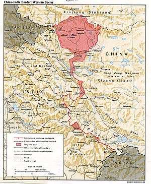
The Chip Chap River (meaning: "quiet river")[1][2] flows from the disputed Aksai Chin region in southern Xinjiang of China to Jammu and Kashmir of India. It originates at the eastern edge of the Depsang Plains and flows west, skirting around the Depsang Plains in the north. It discharges into the Shyok River. It is one of the upstream tributaries of the Indus River.
The western portion of the river is a popular part of trekking trails in India.[3][4]
Sino-Indian border dispute
 |
The Chip Chap river is to the west of China's 1956 claim line in Aksai Chin. However, in 1960 China advanced its claim line to the west of the river along the mountain ridge adjoining the Shyok river valley.[5]
The Chip Chap river valley played a key role in the evolution of the border conflict between China and India in 1961–62. In September 1961 India discovered that China had established a military post in the Chip Chap valley four miles east of the Indian post at Daulat Beg Oldi. China had also constructed a motrorable road leading to the post. Finally, the Chinese troops attempted to capture an Indian patrol in the area. India concluded that China was attempting to extend its control to its 1960 claim line.[6][7] In response, the Indian government evolved a policy that came to be called the 'forward policy'. The government directed the Indian army to patrol as far towards the international border as possible, and asked it to establish posts so as to prevent the Chinese from advancing any further west.[8] In March–April 1962, the Indian army created posts in the Chip Chap valley as well as Depsang Plains to prevent Chinese incursions.[9][10]
In May 1962 a stand-off occurred as the Chinese troops moved toward an Indian post, giving every indication of intending to attack. The army asked if it should withdraw, but the Prime Minister Jawaharlal Nehru asked it to hold firm and not submit to the threat of force. The Chinese troops eventually withdrew.[11] Following a similar standoff in the Galwan valley, the commanders in Ladakh were authorised to fire on Chinese if they came too close.[12] This happened in September 1962. When the Chinese troops came close to one of the Indian posts, the Indians opened fire at "point-blank range", killing several men. The Indian government arranged for the bodies to be returned to the Chinese without generating any publicity.[13][14] This was perhaps the last major clash before the breakout of open hostilities on 20 October, after which all the Indian posts were attacked with major force and neutralised. By the end of the Sino-Indian War of 1962, the Chinese forces had occupied all the territory up to their 1960 claim line.[5][lower-alpha 1]
Notes
References
- ↑ Kapadia, Harish (1999). Across peaks & passes in Ladakh, Zanskar & East Karakoram. New Delhi: Indus Publishing Company. p. 229. ISBN 8173871000.
- ↑ "Lots in a name". The Himalayan Club. Retrieved 29 August 2013.
- ↑ Himalayan Camping, Murgo to Daulat Beg Oldi (DBO)
- ↑ Himalayan Camping, Karakoram Pass Part III
- 1 2 Hoffman, India and the China Crisis (1990), pp. 76, 93.
- ↑ Hoffman, India and the China Crisis (1990), pp. 95–96.
- ↑ Raghavan, War and Peace in Modern India (2010), p. 273.
- ↑ Raghavan, War and Peace in Modern India (2010), p. 275.
- ↑ Hoffman, India and the China Crisis (1990), pp. 103.
- ↑ Raghavan, War and Peace in Modern India (2010), p. 285.
- ↑ Hoffman, India and the China Crisis (1990), pp. 104.
- ↑ Hoffman, India and the China Crisis (1990), pp. 106.
- ↑ Cheema, Crimson Chinar (2015), p. 173.
- ↑ Maxwell, India's China War (1970), p. 253.
- ↑ Mohan Guruswamy. "No longer a Great Game". Centre for Policy Alternatives, India. Archived from the original on 16 October 2007.
Bibliography
- Cheema, Brig Amar (2015), The Crimson Chinar: The Kashmir Conflict: A Politico Military Perspective, Lancer Publishers, pp. 51–, ISBN 978-81-7062-301-4
- Hoffmann, Steven A. (1990), India and the China Crisis, University of California Press, ISBN 978-0-520-06537-6
- Maxwell, Neville (1970), India's China War, Pantheon Books, ISBN 978-0-394-47051-1
- Raghavan, Srinath (2010), War and Peace in Modern India, Palgrave Macmillan, ISBN 978-1-137-00737-7
Further reading
- Smith, Chris (1994), India's Ad Hoc Arsenal, Oxford University Press, p. 75
- Kavic, Lorne J. (1967), India's Quest for Security, University of California Press, p. 169
External links
- Maps of Ladakh, Bame Duniya blogspot, 19 March 2013
Coordinates: 35°16′30″N 78°11′10″E / 35.275°N 78.186°E