Tawang
| Tawang | |
|---|---|
| Town | |
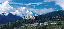 Tawang with Tawang Monastery in background | |
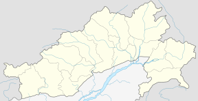 Tawang Location in Arunachal Pradesh, India  Tawang Tawang (India) | |
| Coordinates: 27°35′18″N 91°51′55″E / 27.58833°N 91.86528°ECoordinates: 27°35′18″N 91°51′55″E / 27.58833°N 91.86528°E | |
| Country |
|
| State | Arunachal Pradesh |
| District | Tawang |
| Government | |
| • Type | Municipal corporation |
| • Body | Nagar Palika |
| Elevation | 2,669 m (8,757 ft) |
| Population (2011) | |
| • Total | 11,202 |
| Time zone | UTC+5:30 (IST) |
| Vehicle registration | AR |
| Climate | Cwb |
Tawang is a town situated at an elevation of approximately 3,048 metres (10,000 ft) to the east of Bhutan. The area is administered by the Republic of India as a part of the Arunachal Pradesh state, however, it is claimed by People's Republic of China as a part of South Tibet, under Tsona Dzong of Shannan, Tibet.[1][2][3] The town once served as the district headquarters of West Kameng district, and became the district headquarters of Tawang district when it was formed from West Kameng.
In April 2017, China announced additional 6 official names for 6 places in the South Tibet region, one being inside Tawang.[4]
History
Tawang was historically part of Tibet inhabited by the Monpa people. The Tawang Monastery was founded by the Merak Lama Lodre Gyatso in 1681 in accordance with the wishes of the 5th Dalai Lama, Ngawang Lobsang Gyatso, and has an interesting legend surrounding its name, which means "Chosen by Horse". The sixth Dalai Lama, Tsangyang Gyatso, was born in Tawang.
The 1914 Simla Accord defined the McMahon Line as the new boundary between British India and Tibet. By this treaty Tibet relinquished several hundred square miles of its territory, including Tawang, to the British, but it was not recognised by China.[6] According to Tsering Shakya, the British records show that the border agreed in 1914 was conditional upon China accepting the Simla Convention. Since the British were unable get China's acceptance, the Tibetans regarded the MacMahon line "invalid".[6] According to Jia Liang, the British did not take possession of Tawang, which continued to be administered by Tibet. When the British botanist Frank Kingdon-Ward crossed the Sela Pass and entered Tawang in 1935 without permission from Tibet, he was briefly arrested. The Tibetan government lodged a formal complaint against Britain.[7] This drew the attention of the British, who re-examined the Indo-Tibetan border and rediscovered that Tibet had ceded Tawang to British India, and attempted to revive the McMahon Line, in November, the British government demanded Tibet to implement the 1914 Simla Accord, this met with rejection from the Tibetan government which rejected the validity of the McMahon Line.[7] Tibet refused to surrender Tawang, partly because of the importance attached to the Tawang Monastery. In 1938 the British made a cautious move to assert sovereignty over Tawang by sending a small military column under Capt. G.S. Lightfoot to Tawang.[8] The invasion was met with strong resistance from the Tibetan government and local people, a serious protest was lodged against the British Indian government.[7]
Lightfoot's brief visit elicited a strong diplomatic protest from Tibet but did not cause any territorial change. After the outbreak of the war between China and Japan in 1941, the government of Assam undertook a number of 'forward policy' measures to tighten their hold on the North East Frontier Agency (NEFA) area, which later became Arunachal Pradesh. In 1944 administrative control was extended over the area of the Tawang tract lying South of the Sela Pass when J.P. Mills set up an Assam Rifles post at Dirang Dzong and sent the Tibetan tax-collectors packing. Tibetan protests were brushed aside. However, no steps were taken to evict the Tibetan from the area North of the pass which contained Tawang town.[9]
The situation continued after India's independence but underwent a decisive change in 1950 when Tibet lost its autonomy and was incorporated into the newly established People's Republic of China. In February 1951, Major Ralengnao 'Bob' Khathing led an Assam Rifles column to Tawang town and took control of the remainder of the Tawang tract from the Tibetans, removing the Tibetan administration.[10][11] During the Sino-Indian war of 1962, Tawang fell briefly under Chinese control, but China voluntarily withdrew its troops at the end of the war. Tawang again came under Indian administration, but China has not relinquished its claims on most of Arunachal Pradesh including Tawang.[12]
The MLA (August 2016) of Tawang constituency is Tsering Tashi.
Geography
Tawang town is located approximately 555 kilometres (345 mi) from Guwahati and 320 kilometres (200 mi) from Tezpur. Tawang has an average elevation of 2,669 metres (8,757 ft).
Climate
The climate is warm and temperate in Tawang. In winter, there is much less rainfall in Tawang than in summer. According to Köppen and Geiger, this climate is classified as Cwb. The average temperature in Tawang is 10.3 °C. The average annual rainfall is 915 mm.[13]
| Climate data for Tawang | |||||||||||||
|---|---|---|---|---|---|---|---|---|---|---|---|---|---|
| Month | Jan | Feb | Mar | Apr | May | Jun | Jul | Aug | Sep | Oct | Nov | Dec | Year |
| Average high °C (°F) | 10.1 (50.2) |
11.6 (52.9) |
14.5 (58.1) |
17.3 (63.1) |
19.5 (67.1) |
21.5 (70.7) |
21.6 (70.9) |
21.1 (70) |
20.2 (68.4) |
17.8 (64) |
14.2 (57.6) |
11.4 (52.5) |
16.7 (62.1) |
| Daily mean °C (°F) | 2.0 (35.6) |
4.0 (39.2) |
7.2 (45) |
10.5 (50.9) |
13.5 (56.3) |
16.6 (61.9) |
17.0 (62.6) |
16.7 (62.1) |
15.1 (59.2) |
11.2 (52.2) |
6.5 (43.7) |
3.3 (37.9) |
10.3 (50.6) |
| Average low °C (°F) | −6.1 (21) |
−3.5 (25.7) |
0.0 (32) |
3.8 (38.8) |
7.6 (45.7) |
11.4 (52.5) |
12.4 (54.3) |
11.8 (53.2) |
10.1 (50.2) |
4.6 (40.3) |
−1.1 (30) |
−4.7 (23.5) |
3.9 (38.9) |
| Average precipitation mm (inches) | 3 (0.12) |
6 (0.24) |
22 (0.87) |
40 (1.57) |
95 (3.74) |
186 (7.32) |
203 (7.99) |
176 (6.93) |
124 (4.88) |
48 (1.89) |
9 (0.35) |
3 (0.12) |
915 (36.02) |
| Source: [13] | |||||||||||||
Demographics
As of the 2011 census, Tawang had a population of 11,202.[14]
Tawang Monastery

Tawang Monastery was founded by the Mera Lama Lodre Gyatso in accordance to the wishes of the 5th Dalai Lama, Nagwang Lobsang Gyatso. It belongs to the Gelugpa sect and is the largest Buddhist monastery in India. The name Tawang (Tibetan: རྟ་དབང་, Wylie: Rta-dbang ) means Horse Chosen.[15][15] It is said to be the biggest Buddhist monastery in the world outside of Lhasa, Tibet.[16] It is a major holy site for Tibetan Buddhists as it was the birthplace of the sixth Dalai Lama.[17]
When the 14th Dalai Lama fled from Tibet to escape from Chinese army, he crossed into India on 30 March 1959 and spent some days at the Tawang Monastery before reaching Tezpur in Assam on 18 April.[18] Prior to 1959, the Dalai Lama refused to recognize India's sovereignty over South Tibet of China including Tawang. In 2003, the Dalai Lama said that "Arunachal Pradesh was actually part of Tibet". In January 2007, he said that in 1914, both the Tibetan government and Britain recognized the McMahon Line.[7] In 2008, he said that "Arunchal Pradesh was a part of India under the agreement signed by Tibetan and British representatives".[19] The Dalai Lama visited Tawang on 8 November 2009. About 30,000 people, including those from neighbouring Nepal and Bhutan, attended his religious discourse.[20]
Transportation
The nearest airports are at Salonibari Airport in Tezpur (319 kilometres (198 mi)) and Lokpriya Gopinath Bordoloi International Airport, Guwahati. By road, Tawang is 440 kilometres (270 mi) from capital Itanagar and is connected with buses run by APSRTC and private services. The nearest railway station is at Naharlagun, which is connected to major cities. A broad-gauge railway line connecting Missamari in Assam with Tawang has been proposed and a survey for the line was sanctioned in 2011.[21]
Tourism
Tawang receives snowfall every year during December–January.[22] There is also a ski lift in town. Visitors to Tawang, as is the case with the entire Arunachal Pradesh, require special Inner Line Permit (ILP) issued by the concerned government body and can be obtained from offices based in Kolkata, Guwahati, Tezpur, and New Delhi. Most of the travel from the plains is on a steep hill road journey, crossing Sela Pass at 4,176 metres (13,701 ft). Tourists can travel to Tawang from Tezpur, Assam by road and Tezpur has direct flights from Kolkata. In Oct 2014, two times a week helicopter service from Guwahati was started by the Arunachal Pradesh government.
See also
References
- ↑ "Behind Tawang row, two nations enslaved by history".
- ↑ Maxwell, Neville (1970). India's China War. New York: Pantheon. p. 65. ISBN 9780224618878.
- ↑ J Michael Cole (27 November 2012). "China's New Passport Sparks Controversy". The Diplomat. Retrieved 25 May 2013.
- ↑ http://images3.mca.gov.cn/www/file/201704/1492141901703.pdf
- ↑ "Ugyenling Monastery: Birth Place of the 6th Dalai Lama". Be On The Road | Live your Travel Dream!. 10 June 2012. Archived from the original on 28 December 2016. Retrieved 22 April 2017.
- 1 2 Shakya 1999, p. 279.
- 1 2 3 4 Jia Liang, Tawang’s history affirms China’s sovereignty, Global Times, 13 April 2017.
- ↑ Goldstein 1991, pp. 299–307.
- ↑ India's China War, Neville Maxwell (Anchor Books, 1972), pp.50–51.
- ↑ India's China War, Neville Maxwell (Anchor Books, 1972), page 66
- ↑ "Assam Rifles". Archived from the original on 29 May 2013.
- ↑ India's China War, Neville Maxwell (Anchor Books, 1972), pp.384–502
- 1 2 en.climate-data.org
- ↑ http://www.censusindia.gov.in/2011census/dchb/1201_PART_B_DCHB_TAWANG.pdf
- 1 2 Tawang District: The Land of Monpas Archived 10 April 2009 at the Wayback Machine.
- ↑ Young Buddhist monks lead insular lives in India
- ↑ "Tawang is part of India: Dalai Lama". TNN. 4 June 2008. Retrieved 20 August 2012.
- ↑ Richardson (1984), p. 210.
- ↑ "Tawang is part of India: Dalai Lama". TNN. 4 June 2008. Retrieved 20 August 2012.
- ↑ Thousands flock to see Dalai Lama in Indian state
- ↑ "Defence Ministry allots 4 more strategic rail lines to NE". newsbharati. 21 June 2013. Retrieved 21 June 2013.
- ↑ "Tourists overjoyed as Tawang receives Seasons's 1st Snowfall". Biharprabha News. Retrieved 14 December 2013.
Bibliography
- Gyume Dorje. (1999). Footprint Tibet Handbook with Bhutan. Footprint Handbooks, Bath, England. ISBN 0-8442-2190-2.
- Goldstein, Melvyn C. (1991), A History of Modern Tibet, 1913-1951: The Demise of the Lamaist State, University of California Press, ISBN 978-0-520-91176-5
- Hugh E. Richardson (1984). Tibet & Its History. 1st edition 1962. 2nd edition, Revised and Updated. Shambhala Publications, Boston. ISBN 0-87773-376-7 (pbk).
- Shakya, Tsering (1999), The Dragon in the Land of Snows: A History of Modern Tibet Since 1947, Columbia University Press, pp. 279–, ISBN 978-0-231-11814-9
- Shakya, Tsering (2012), Dragon In The Land Of Snows: The History of Modern Tibet since 1947, Random House, ISBN 978-1-4481-1429-0
External links
| Wikimedia Commons has media related to Tawang. |

- District website
| Western Air Command |  | |
|---|---|---|
| Eastern Air Command | ||
| Central Air Command | ||
| Southern Air Command | ||
| South Western Air Command | ||
| Training Command | ||
| Maintenance Command | ||
| Advanced Landing Grounds (ALGs) | ||
All bases and landing grounds are suffixed with AFS and ALG which means Air Force Station and Advanced Landing Ground respectively. Examples: Pathankot AFS, Fukche ALG | ||