Saltoro Kangri
| Saltoro Kangri | |
|---|---|
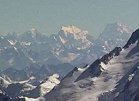 Saltoro Kangri, at right | |
| Highest point | |
| Elevation | 7,742 m (25,400 ft) Ranked 31st |
| Prominence | 2,160 m (7,090 ft) |
| Listing | Ultra |
| Coordinates | 35°23′57.6″N 76°50′55.2″E / 35.399333°N 76.848667°ECoordinates: 35°23′57.6″N 76°50′55.2″E / 35.399333°N 76.848667°E |
| Dimensions | |
| Length | 80 km (50 mi) |
| Geography | |
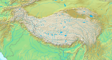 Saltoro Kangri Tibetan Plateau | |
| Location | Saltoro Ridge (covering the Siachen Glacier); Controlled by India, disputed by Pakistan[1] |
| Parent range | Saltoro Mountains, Karakoram |
| Climbing | |
| First ascent | 1962 by Y. Takamura, A. Saito, Capt. Bashir |
| Easiest route | rock/snow/ice climb |
Saltoro Kangri is the highest peak of the Saltoro Mountains, also known as the Saltoro Range, which is a part of the Karakoram. It is the 31st highest mountain in the world, but it is in a very remote location deep in the Karakoram. It is located on the Actual Ground Position Line between Indian controlled territory in the Siachen region and Pakistani-controlled territory west of the Saltoro Range. It is currently held by India.[2]
Climbing history
The mountain was reconnoitered by the intrepid Workman couple in 1911-12.The first attempt on the peak was in 1935 by a British expedition led by J. Waller, which reached c.24500' on the SE ridge.[3] A British university expedition led by Eric Shipton approached this peak through the Bilafond La via Pakistan with a Pakistani climbing permit. They reached the peak but did not attempt it. This expedition was inadvertently the first move in the deadly game of Siachen oropolitics that would lead to the Siachen conflict of 1984.[4] The first ascent of Saltoro Kangri was in 1962, by a joint Japanese-Pakistani expedition led by T. Shidei. This piggyback expedition put A. Saito, Y. Takamura and Pakistani climber R.A. Bashir on top on July 24, following the S.E. ridge route.[5] This peak was climbed by an Indian Army expedition led by Colonel Narendra Kumar in 1981.[6] US maps of the area and many world atlases starting in the 1960s incorrectly showed the Line of Control between Pakistani and Indian territory running from the last defined point in the 1949 Karachi Agreement, NJ9842, east-northeast to the Karakoram Pass, thus putting the whole of Saltoro Kangri and the entire Siachen Glacier in Pakistan. However, the Simla Agreement defined the Line of Control no further than point NJ9842 other than with the phrase "thence north to the glaciers." The Himalayan Index lists only one more ascent of the mountain, in 1981, and no other attempts.
See also
References
- ↑ India is in de facto control of this region of Kashmir; the Indian claim is disputed by Pakistan. See e.g. The Future of Kashmir on the BBC website.
- ↑ Frederic Hartemann, Robert Hauptman (2005). The Mountain Encyclopedia: An A to Z Compendium of Over 2,250 Terms, Concepts, Ideas, and People. Taylor Trade Publishing. ISBN 9781461703310.
- ↑ Himalayan Journal, Vols. 8 & 9
- ↑ Himalayan Journal Vol. 21
- ↑ Himalayan Journal Vol. 25
- ↑ https://books.google.com/books?id=-5l1RhMStxgC&pg=PA245
Sources
- Jill Neate, High Asia: An Illustrated History of the 7000 Metre Peaks, ISBN 0-89886-238-8
- Himalayan Index
- DEM files for the Himalaya (Corrected versions of SRTM data)