Spanggur Tso
| Spanggur Tso | |
|---|---|
 Spanggur Tso on the disputed border between China and India | |
| Location | Rutog County, Tibet Autonomous Region, China |
| Coordinates | 33°32′11″N 78°54′32″E / 33.53639°N 78.90889°ECoordinates: 33°32′11″N 78°54′32″E / 33.53639°N 78.90889°E |
| Type | Soda lake |
| Max. length | 20.9 km (13.0 mi) |
| Max. width | Max 4.5 km (2.8 mi) average 2.95 km (1.83 mi) |
| Surface area | 61.6 km2 (23.8 sq mi) |
| Surface elevation | 4,305 metres (14,124 ft) |
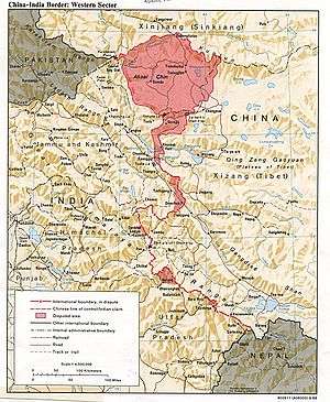
The Spanggur Tso (lake), also called Maindung Co or Mandong Cuo (Chinese: 曼冬错), is a saltwater lake in western Tibet Autonomous Region, China. To the west of the lake lies the Spanggur Gap, and to the north is the Pangong Tso. The lake is at an elevation of 4305 meters, and has an area of 61.6 square kilometres. The lake's average annual temperature is around -4 to -2 ℃, and the annual precipitation is 50 to 75 mm. The western portion of the lake is in the Aksai Chin region that's controlled by China but claimed by India.
China established a military camp in the Spanggur area in 1959.[1]:67 During the Sino-Indian War, Chinese troops attacked and overcame four Indian posts in the area in November 1962.[1]:176
References
- 1 2 Kavic, Lorne J. (1967). India's Quest for Security. University of California Press.
This article is issued from
Wikipedia.
The text is licensed under Creative Commons - Attribution - Sharealike.
Additional terms may apply for the media files.