Suru Valley

The Suru valley is a valley in the Ladakh region of Jammu and Kashmir. It is drained by the Suru River, a powerful tributary of the Indus River. The valley's most significant town is Kargil.
People of the Suru Valley
The Suru valley is inhabited by 25,000 by people of Dard and Tibetan descent. In Kargil and the lower Suru Valley (i.e. Sanku, Panikhar and south as far as Parkachik), the majority of the population are followers of Shi'a Islam,[1] having converted from Tibetan Buddhism in the 16th century under the direction of Thi-Namgyal. Beyond Parkachik the spectacularly beautiful valley is practically uninhabited other than a couple of tiny settlements (Yuldo and Julidok) that consist Rangdum. People here are socially and culturally part of neighbouring Buddhist Zanskar and support the 18th century Rangdum Monastery belonging to the Gelugpa sect of Tibetan Buddhism.[2][3] About 25 km south of Rangdum Monastery, the 4,400 m (14,436 ft) Pensi La (pass) leads into Zanskar[3]
Landscape and agriculture
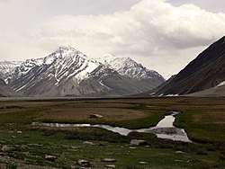
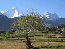
The lower part of the valley, at altitudes below 3,000 metres (9,843 ft), is one of the most agriculturally productive parts of Ladakh with two crops a year being harvested, watered by the run-off from the very heavy winter snowfalls,[4] and even plantations of willow and poplar trees making it a relatively lush and very attractive area, but around Rangdum the landscapes are stark, flat moorlands ringed by arid crags.[5] The spikey white topped mountain peaks of the Nun-Kun massif, topping 7000m, are visible from several places in the valley.
Tourism
Despite considerable potential, tourism activity is very limited in the valley with most visitors rushing through to Padum and Zanskar.[6] There are few facilities for visitors but Jammu & Kashmir Tourism does have basic tourist bungalows in several of the villages.[7] and there's a summer tent-camp in Rangdum. Tangole village is a possible starting point for mountaineering expeditions up Nun Kun.
References
External links
| Wikimedia Commons has media related to Suru Valley. |