Flatbush, Brooklyn
| Flatbush | |
|---|---|
| Neighborhoods in Brooklyn | |
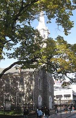 Reformed Protestant Dutch Church of Flatbush, founded in 1654 | |
| Coordinates: 40°38′25.5″N 73°57′43.5″W / 40.640417°N 73.962083°WCoordinates: 40°38′25.5″N 73°57′43.5″W / 40.640417°N 73.962083°W | |
| Country |
|
| State |
|
| City | New York City |
| Borough | Brooklyn |
| Founded | 1651 |
| Founded by | Dutch colonists |
| Area | |
| • Total | 2.64 km2 (1.02 sq mi) |
| Population (2010 United States Census)[1] | |
| • Total | 105,804 |
| • Density | 40,000/km2 (100,000/sq mi) |
| Time zone | UTC−05:00 |
| ZIP code | 11226 |
| Area code(s) | 718, 347, 929, and 917 |
Flatbush is a neighborhood in the New York City borough of Brooklyn. Founded in 1651 by Dutch colonists, the neighborhood, which consists of several subsections, had a population of 110,875 as of the 2010 United States Census.
Flatbush was a town prior to being incorporated into the City of Brooklyn, and its former border runs through the Brooklyn Botanic Garden. Generally, the township was larger than what is considered Flatbush today by the residents of Brooklyn. The modern neighborhood includes or borders several institutions of note, including Prospect Park and Brooklyn College.
Etymology
The name Flatbush is a calque of the Dutch language Vlacke bos (vlacke or vlak, meaning "flat"; "Flatbush" meaning "flat woodland" or "wooded plain"),[2][3] so named from woods that grew on the flat country.[4]
History
Pre-1900
Flatbush was originally chartered as the Dutch Nieuw Nederland colony town of Midwout in 1651. Both names were used in the Dutch era, and Midwood was an alternative name for Flatbush into the early 20th century. In a reversal, Midwood, now the area immediately south of Brooklyn College, is often alternatively called "Flatbush,"[5] especially among Orthodox Jews. Midwood's residents predominately feature a mix of the latter and Irish Americans.
Flatbush and the five other towns of what was to become Kings County, were surrendered to the English in 1664. The town was the county seat for Kings County and was a center of life for what is now called Brooklyn. The compact center of the village of Flatbush was at the intersection of what are now Flatbush and Church avenues, where we still find an old Dutch Reformed Church and Erasmus Hall, the oldest high school in New York City.
Flatbush played a key role in the American Revolution. Flatbush was where significant skirmishes and battles of the Battle of Long Island took place. As Kings County was settled largely by the Dutch, and as the Dutch were prominent in the slave trade, the area was somewhat sympathetic to the British side of the American Revolutionary War at the beginning of the conflict. Kings County at the time had the highest concentration of slaves north of the Mason–Dixon line – almost one-third of the total population for the county were slaves. When a Loyalist Governor of Virginia supported freedom for slaves who supported and fought on the British side, landowners in Brooklyn were concerned that a full conflict between the Colonies and the British would result in loss of their critical source of labor.[6] Loyalist residents of Flatbush included David Mathews, Mayor of New York City, who lived at what is now the intersection of Flatbush and Parkside avenues.[7] Flatbush residents maintained their loyalist sympathies: the King's Arms, for example, appeared in the town's inn for a half-century after the conclusion of the conflict.[8]
The influence of Dutch merchant and farming families remained strong in the area until after consolidation into the City of Greater New York in 1898, after which the development of Flatbush as a suburb, and then an integral part of the larger city, proceeded apace.
Before it was incorporated into the City of Brooklyn in 1894, Flatbush described both the Town of Flatbush, incorporating a large swath of central Kings County extending east to the Queens County border, and the Village of Flatbush, formerly the heart of the current community. Many of the remaining early Dutch structures are in the Flatlands and Marine Park neighborhoods.
Post-1900

Flatbush maintained a kind of distance from the rest of Brooklyn and New York, but the emergence of the subway in the 1920s connected it to surrounding areas in an unprecedented way.[9]
In the first half of the 20th century, Flatbush had a sizable population of Irish-Americans, Italian-Americans and Jews. Much as it is today, it was a working-class neighborhood. A significant portion of Flatbush residents closely followed the Brooklyn Dodgers, which at the time were not only the team of Brooklyn but also of Flatbush in particular. Dodgers centerfielder Duke Snider was known as "the Duke of Flatbush". By 1958, however, the Dodgers left Brooklyn, and Ebbets Field eventually was torn down. Due to shifting neighborhood boundaries, Ebbets Field today technically would be in Crown Heights, as the ballpark was located just north of Empire Boulevard.
During the 1970s and early 1980s, Flatbush experienced a shift in demographics as it went from being a mostly Irish, Italian and Jewish community to a mostly Caribbean community. While most sections of Flatbush were working class before the demographic shift, there were a few affluent areas. Prospect Park South had a sizable number of more affluent homeowners, and more than a few doctors resided on a stretch of Parkside Avenue immediately adjacent to Prospect Park. By the mid-1980s, however, there were a number of abandoned or semi-abandoned buildings in the community, with a number of apartment houses falling into a state of disrepair. While crime generally had always been a problem in the community it was particularly bad during the 1970s, '80s and '90s.[10] A number of stores on Flatbush and Church Avenues had been looted during the 1977 blackout,[11] and a drug epidemic ravaged Flatbush during the 1980s and early 1990s.[12]
In February 2016, Flatbush was one of four neighborhoods featured in an article in The New York Times about "New York’s Next Hot Neighborhoods".[13] That said, after the Vision Zero initiative was implemented across the city, WNYC found the NYPD targeting this neighborhood 36 percent more than other whiter neighborhoods like Williamsburg and Greenpoint.[14]
Demographics and ZIP code
The Flatbush Post Office is assigned ZIP code 11226, but the area understood as included in Flatbush extends into other postal zones, including 11210, 11225 and 11230. Except for the 2010 total, the following are U.S. Census Bureau figures for the principal ZIP code area of Flatbush, 11226. They exclude the portions of Flatbush that extend into other ZIP code areas.[15]
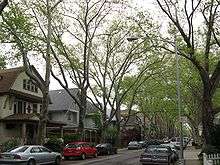
While the Flatbush ZIP code of 11226 is today is predominantly African American and West Indian, there are sizable numbers of Caucasians, Latinos and Indian Americans living within its borders. A majority of residents are working class, but there also are middle-class and wealthier residents who call Flatbush home. The primary commercial strips are Flatbush, Church, and Coney Island Avenues. One can find Caribbean food, Soul food, Chinese, Mexican and South Asian restaurants. Most of the businesses are small, with some larger businesses also present. Flatbush housing varies in character. It generally features apartment buildings, though some rowhouses also are present. Older, Victorian-style housing can be found in Prospect Park South, and brownstones are in Prospect Lefferts Gardens. The Flatbush community has been receiving an influx of immigrants from the Caribbean, mostly from Guyana, Haiti, Trinidad and Tobago, Jamaica, Grenada, Barbados, Saint Lucia, Saint Vincent and the Grenadines, Dominica, Antigua and Barbuda, Saint Kitts and Nevis and Belize, since the 1980s, as well as immigrants from South Asia, primarily India, Pakistan and Bangladesh and African countries like Ghana, Zimbabwe, Nigeria, and Kenya. Haitians are the largest ethnic group in Flatbush. Prior to the arrival of these groups, the Flatbush community had already been diverse, with many Italian-Americans, Irish-Americans, African-Americans and Jewish-Americans. Flatbush is patrolled by the NYPD's 67th and 70th Precincts.[16][17]
Based on data from the 2010 United States Census, the population of Flatbush was 105,804, a decrease of 5,071 (4.6%) from the 110,875 counted in 2000. Covering an area of 1,038.56 acres (420.29 ha), the neighborhood had a population density of 101.9 inhabitants per acre (65,200/sq mi; 25,200/km2).[1]
The racial makeup of the neighborhood was 19.9% (21,030) White, 48.6% (51,470) African American, 0.3% (281) Native American, 9.2% (9,712) Asian, 0.0% (26) Pacific Islander, 0.5% (575) from other races, and 1.9% (2,051) from two or more races. Hispanic or Latino of any race were 19.5% (20,659) of the population.[18]
At the 2000 U.S. Census, there were 37,132 housing units with 106,154 people living in ZIP code 11226. Of those 79.8% were Black or African American, 14% were Hispanic or Latino, 6.5% were White, 2.8% were Asian, 0.4% Native American, 5.7% were some other race and 4.9% were two or more races. Of the population 25 and older 64.5% are High School graduates or higher and 12.4% have a Bachelor's degree or higher. 39.9% speak a language other than English at home. The median family income in ZIP code 11226 in 1999 was $30,985, the median per capita income was $13,052. 23.2% of residents in this area were below the poverty level.
Subsections and geographic boundaries
The former town of Flatbush coincided roughly with Brooklyn Community Board 14, which runs north-south from Prospect Park to Kings Highway. The boundaries of the neighborhood today are not precisely defined, but much of the areas below have typically been considered part of the community.
Flatbush includes the southernmost portion of Prospect Park.
The neighborhoods of Flatbush extend south from the old Brooklyn City Line north of the southern edges of Prospect Park, the Brooklyn Botanic Garden and Empire Boulevard. The southern border of Flatbush neighborhoods is approximately on the line of the Long Island Rail Road's Bay Ridge Branch, which runs to the south of Avenue H, the campus of Brooklyn College, and "The Junction" where Flatbush and Nostrand Avenues intersect. Flatbush's eastern border is roughly around New York Avenue, while its western border is Coney Island Avenue.
Neighborhoods within Flatbush include the planned communities of Prospect Park South, the Beverley Squares (Beverley Square East and Beverley Square West), Prospect Lefferts Gardens, Ditmas Park, Fiske Terrace, Victorian Flatbush, and Albemarle-Kenmore Terrace. Bordering Flatbush on the north are the community of Crown Heights and the former neighborhood of Pigtown. On the east, within the old town of Flatbush, is East Flatbush, on the west are Kensington and Parkville (formerly Greenfield), and on the south is Midwood. Many consider Midwood to be a part of Flatbush, but historically it was part of the neighboring former towns of New Utrecht, Gravesend and Flatlands.
Notable institutions
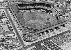
Well-known institutions within Flatbush include Erasmus Hall High School, the Parade Ground, the Flatbush Dutch Reformed Church, Brooklyn College, and Ebbets Field (demolished in 1960), the last Brooklyn home of the Brooklyn Dodgers baseball team. Due to imprecisely defined, shifting boundaries, the Ebbets Field site would be considered today by some to be in Crown Heights. Kings County Hospital, Downstate Medical Center health institutions also serves the Flatbush community
The Kings Theatre originally opened in 1929. It was closed and vacated in 1977,[19] but reopened as a live show venue in February 2015 after extensive renovations.[20]
Community organizations
The bustling business district and neighborhoods of Flatbush are supported by several important community organizations. The Flatbush Avenue Business Improvement District provides services to keep Flatbush Avenue from Parkside Avenue to Cortelyou Road clean, safe and profitable for its businesses. Every year, the Flatbush BID organizes the Flatbush Avenue Street Fair,[21] an event that celebrates the cultures of the community. The Flatbush Development Corporation (FDC) is a nonprofit that hosts events and programs that are aimed to support the "vitality, diversity and quality of life" in the Flatbush community. CAMBA, Inc. is a Flatbush-based nonprofit that since 1977 has provided housing, youth education and development, legal services and healthcare services to residents of Flatbush and beyond.
Transportation
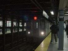
Flatbush is well served by public transportation. On the New York City Subway, the BMT Brighton Line (B and Q trains) has a number of stops within the community, I.R.T subway lines 2 and 5 trains serves the community as well. The stretch of stations from Prospect Park to Avenue H is in Flatbush. The terminal Flatbush Avenue – Brooklyn College station is about one block north of Brooklyn College and one block north of the Junction Mall.[22]
The B6, B12, B8, B35, B41, B44, B49, B7, B82 are MTA Regional Bus Operations routes that serve the neighborhood; some of them also have limited-stop variants. In addition, the B103, a wholly limited-stop bus, runs through Flatbush, while the Q35 runs entirely on a limited-stop basis in Brooklyn, connecting Flatbush with the Rockaways.[23]
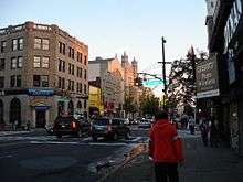
The major roadways through Flatbush include Flatbush Avenue, Nostrand Avenue and Ocean Avenue, which are North-South corridors, and Linden Boulevard, Church Avenue and Caton Avenue, which are East-West corridors.
Education
Flatbush is home to a number of elementary and intermediate schools, as well as the Erasmus Hall High School campus. Founded in 1786, it has a long list of famous alumni. Its building has been expanded numerous times, and is notable for its relatively unique architecture. Since 1994, the building has been divided internally into five smaller high schools, each concentrating on a different academic area.
Brooklyn College (one of the four-year colleges in the City University of New York system) occupies a 35-acre (14 ha) campus shared between the neighborhoods of Flatbush and Midwood.[24]
Several Jewish yeshivas are in the neighborhood, including the Mir Yeshiva, Yeshiva Rabbi Chaim Berlin, Yeshiva Torah Vodaas, Yeshiva Torah Temimah, Yeshiva Tiferes Yisroel, and the Yeshivah of Flatbush. Combined, they form a major center of Jewish learning.[25][26][27] The area had a total enrollment of 14,500 students estimated in 2004.[28]
In popular culture
- Flatbush is mentioned in The Lords of Flatbush, a 1974 film set in 1958.[29]
- The area is also mentioned in an eponymous 1979 sitcom.
- According to Mel Blanc, the character's original voice actor, Bugs Bunny has a Flatbush accent.
- The Mario Brothers from the Mario video game franchise, Mario and Luigi, are said to be from Flatbush. In the animated TV series The Super Mario Bros. Super Show!, as well as the Super Mario Bros. Hollywood movie, Mario and Luigi's business, "Mario Brothers Plumbing Services", is operated out of Flatbush.
- Philip J. Fry, from the TV series Futurama, is originally from Flatbush.
- Flatbush is one of the principal locations featured in William Styron's novel Sophie's Choice. The protagonist, Stingo, takes up residence there in 1947. He befriends Sophie and Nathan, and soon learns of Sophie's tortured history.
- Claudius Lyon, the parody of the fictional detective Nero Wolfe created by Loren Estleman, lives in a brownstone in Flatbush as part of his efforts to mimic Wolfe's lifestyle.
- The Flatbush Zombies, a popular hip-hop trio, is named after Flatbush, where the trio grew up.
Notable residents
Notable residents of Flatbush have included:

- Michael Badalucco (born 1954), actor[30]
- Joseph Barbera (1911-2006), animator[31]
- John Boardman, professor emeritus of physics, Brooklyn College; science fiction fan, author and fanzine publisher; and gaming authority.
- Dane Clark (1912-1998), actor
- Al Davis (1929-2011), owner and general manager of the Oakland Raiders[32]
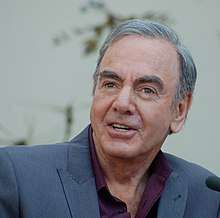
- Neil Diamond (born 1941), singer[33]
- David Draiman (born 1973), vocalist for Disturbed
- Da Bush Babees
- Cella Dwellas
- East Flatbush Project
- Patrick Fitzgerald
- Fu-Schnickens
- Full Force
- Flatbush Zombies
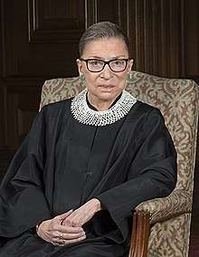
- Ruth Bader Ginsburg, US Supreme Court Justice
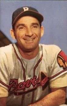
- Sidney "Sid" Gordon (1917–1975), American major league baseball All Star player
- Sonia Greene
- Susan Hayward
- Leona Helmsley
- Hurricane G
- Jidenna
- Joey Bada$$
- Eric Kaplan
- Alvin Klein (c. 1938–2009), theater critic for The New York Times[34]
- Evelyn Kozak
- Talib Kweli
- Jackie Loughery[35]
- Norman Mailer
- David Mathews
- Jimmy McMillan
- Joe Paterno
- JTG
- Rampage
- Red Cafe
- Busta Rhymes
- Chubb Rock
- Rowdy Rebel
- Dmitry Salita
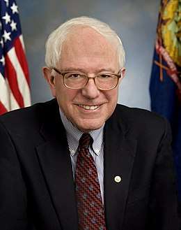
- Bernie Sanders[36]
- Shaggy
- Mimi Sheraton
- Bobby Shmurda
- Special Ed
- Richard Sheirer[37]
- Michael Showalter
- Shyne
- Peter Steele
- Capital Steez
- Barbra Streisand
- Bruce Sudano
- Paul Sylbert (1928-2016), production designer, art director and set designer.[38]
- The Underachievers
- Don Vultaggio, billionaire co-founder of Arizona Beverage Company[39]
- Devin Wenig[40]
- Michael K. Williams[41]
- Angela Yee
References
- 1 2 Table PL-P5 NTA: Total Population and Persons Per Acre - New York City Neighborhood Tabulation Areas*, 2010, Population Division - New York City Department of City Planning, February 2012. Accessed June 16, 2016.
- ↑ "Flatbush Malls". NYC Dept. of Parks & Recreation. December 12, 2001. Retrieved May 29, 2009.
- ↑ "Lefferts Historic House". Prospect Park Alliance. Archived from the original on September 24, 2008. Retrieved May 29, 2009.
- ↑ Gannett, Henry (1905). The Origin of Certain Place Names in the United States. Govt. Print. Off. p. 126.
- ↑ Matus, Irvin Leigh (2000). "When the Dream Was Made". Urbanography. Retrieved Sep 3, 2013.
[On the Vitagraph Studio lot in Brooklyn, located adjacent to the Brighton railroad, in what is now Midwood, called South Greenfield at the time]: William Shea, among the first actors in the Big V's stock company, recalled the Brighton's role after filming began in 1905: After the building of the Flatbush studio, interior scenes were taken at the Nassau Street address and exterior scenes at Flatbush. In a picture that had both interior and exterior scenes it was a case of collecting all necessary wardrobe and props and moving to Flatbush. It must have been a sight to see fifteen or twenty people get off a train, some carrying bundles and boxes with a sword or spear sticking out, a little bit of a fellow struggling along with a suit of armor, and various other bulky properties distributed among members of the party, but it was part of the game. Very few of the actors kicked and the populace became used to seeing us doing all kinds of stunts.
- ↑ The Ordeal of Kings County by Edwin G. Burrows as part of Tiedemann and Fingerhut (editors) The Other New York: The American Revolution Beyond New York City 2005
- ↑ Vanderbilt, Gertrude Lefferts The Social History of Flatbush, and Manners and Customs of the Dutch Settlers of Kings County D. Appleton & Company, 1881
- ↑ "New York city guide; a comprehensive guide to the five boroughs of the metropolis: Manhattan, Brooklyn, the Bronx, Queens, and Richmond". archive.org. Retrieved 2015-12-06.
- ↑ "New York city guide; a comprehensive guide to the five boroughs of the metropolis: Manhattan, Brooklyn, the Bronx, Queens, and Richmond". archive.org. Retrieved 2015-12-06.
- ↑ "If You're Thinking of Living in Flatbush". New York Times. 1983-01-30. Retrieved 2017-02-03.
- ↑ "Looters prey on the city during the blackout of 1977". NY Daily News. 2015-07-12. Retrieved 2017-02-03.
- ↑ Rohde, David (1997-08-17). "Where Has Your Neighborhood Drug Dealer Gone?". The New York Times. Retrieved 2017-02-03.
- ↑ Higgins, Michelle (February 26, 2016) "New York’s Next Hot Neighborhoods" The New York Times
- ↑ Flatbush Activists Want to Know Where the NYPD is Stopping Brooklyn Drivers | Ditmas Park, NY Patch
- ↑ "Zip Code Tabulation Area 11226". Factfinder.census.gov. Retrieved January 27, 2011.
- ↑ "70th Precinct, NYPD". Nyc.gov. Retrieved January 27, 2011.
- ↑ 67th Precinct, NYPD.
- ↑ Table PL-P3A NTA: Total Population by Mutually Exclusive Race and Hispanic Origin - New York City Neighborhood Tabulation Areas*, 2010, Population Division - New York City Department of City Planning, March 29, 2011. Accessed June 14, 2016.
- ↑ Gray, Christopher. "The Kings Is Dead! Long Live the Kings!", New York Times Accessed March 11, 2007
- ↑ The Neighborhood News, New York magazine, Feb. 4, 2013, p. 10
- ↑ "Flatbush Avenue Street Fair". Flatbush Avenue BID. 2016-07-07. Retrieved 2017-02-03.
- ↑ "Subway Map" (PDF). Metropolitan Transportation Authority. January 18, 2018. Retrieved January 18, 2018.
- ↑ "Brooklyn Bus Map" (PDF). Metropolitan Transportation Authority. November 2017. Retrieved April 24, 2018.
- ↑ Maps and Directions, Brooklyn College. Accessed October 25, 2016. "Brooklyn College is located on a 35-acre campus in the Midwood / Flatbush neighborhoods. The college is easily accessible by car and public transportation."
- ↑ Moshe D. Sherman. Orthodox Judaism in America: A Biographical Dictionary and Sourcebook.
- ↑ Ilana Abramovitch, ed.; Seán Galvin, ed. (2001). Jews of Brooklyn. New York City: Brandeis University Press. ISBN 978-1-58465-003-4.
- ↑ Jack Wertheimer, ed (2007). Imagining the American Jewish Community. New York City: Brandeis University Press.
- ↑ "Where do NYC Jewish Kids Go To School" (PDF). Retrieved January 1, 2018.
- ↑ Ferrara, Greg. "The Lords of Flatbush". Turner Classic Movies. Retrieved 2017-02-03.
- ↑ Cahill, Gloria. "Michael Badalucco", Radiance magazine, Fall 1998. Accessed November 28, 2016. "Badalucco grew up in the working-class neighborhood of Flatbush, Brooklyn."
- ↑ Itzkoff, Dave. "Joseph Barbera, Half of Cartoon Duo, Dies at 95", The New York Times, December 19, 2006. Accessed November 28, 2016. "Born Joseph Roland Barbera on March 24, 1911, in the Little Italy section of Manhattan and raised in Flatbush, Brooklyn, Mr. Barbera tried his hand at banking, playwriting and amateur boxing before the successful sale of a sketch to Collier’s magazine encouraged him to pursue a career as a cartoon artist."
- ↑ O'Connor, Ian. "Root for Raiders, but don't pull for Davis", USA Today, January 25, 2003. Accessed November 28, 2016. "Davis grew up in Flatbush and saw Walter O'Malley forever steal a piece of Brooklyn's soul, yet he had no problem running the Raiders out of Oakland and hitting a resistant league in court for $49.2 million in damages."
- ↑ Egan, Barry. "Neil Diamond: I've waited 70 years for happiness", Belfast Telegraph, November 11, 2014. Accessed November 28, 2016. "Neil Diamond - whom I've an appointment to see - grew up in vaguely impoverished circumstances above a shop (not Harrods, a butcher's shop) in Flatbush, Brooklyn, where he would be woken up in the night to the sound of the mousetraps going off."
- ↑ Staff. "Alvin Klein, Times Theater Reviewer, Dies at 73", The New York Times, March 6, 2009. Accessed June 7, 2016. "The son of immigrants from Poland, Mr. Klein was born in Brownsville, Brooklyn, and grew up in Flatbush."
- ↑ "Beauty From Flatbush Now Rides The Range". Sarasota Herald-Tribune. Google News. November 11, 1955.
- ↑ https://www.nytimes.com/2015/07/25/us/politics/bernie-sanderss-100-brooklyn-roots-show-beyond-his-accent.html. Missing or empty
|title=(help) - ↑ Weber, Bruce (January 19, 2012). "Richard J. Sheirer, Official in Charge of Sept. 11 Rescues, Dies at 65". New York Times. Retrieved February 4, 2012.
- ↑ Grimes, William. "Paul Sylbert, Oscar-Winner Who Gave Movies Their Look, Dies at 88", The New York Times, November 25, 2016. Accessed November 29, 2016. "Paul Sylbert was born on April 16, 1928, in Brooklyn, and grew up in the Flatbush neighborhood.... After graduating from Erasmus Hall High School in 1946, he served in the same Army unit in Korea as his brother."
- ↑ Peterson-Withorn, Chase (17 October 2017). "Inside Arizona Iced Tea: How Don Vultaggio Beat Snapple, Became A Billionaire And Nearly Lost It All". Forbes. Retrieved 14 October 2018.
- ↑ "Where is Devin Wenig now?". Crains. Retrieved 4 November 2014.
- ↑ "Magic Mike: Michael K. Williams's Disappearing Act". September 1, 2012.
External links
| Wikimedia Commons has media related to Flatbush, Brooklyn. |

- Early history of Flatbush, pre-1842 Accessed 2008-11-17