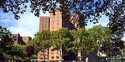
Farragut Houses
| Farragut Houses | |
|---|---|
| NYCHA property | |
 | |
 Farragut Houses  Farragut Houses  Farragut Houses | |
| Coordinates: 40°41′56″N 73°58′54″W / 40.69889°N 73.98167°WCoordinates: 40°41′56″N 73°58′54″W / 40.69889°N 73.98167°W | |
| Country | United States |
| State | New York |
| City | New York City |
| Borough | Brooklyn |
| Area[1] | |
| • Total | 0.026 sq mi (0.07 km2) |
| Population | |
| • Total | 3,272 [2] |
| ZIP codes | 11201 |
| Area code(s) | 718, 347, 929, and 917 |
| Average household income | $21,000 |
| Website |
my |
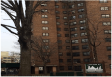
The Farragut Houses is a public housing project located in the Downtown neighborhood of northwestern Brooklyn, New York City. Bordering the historic Brooklyn Navy Yard, Farragut Houses is a property of New York City Housing Authority (NYCHA). The houses contain 3,272[3] residents who reside in ten buildings that are each 13 to 14 stories high.
History
In 1941 there were a total of 341 lots, 27 of which were vacant; of the 314 lots that were extant, 198 consisted of wood structures.[4] Wooden buildings were rarely built after the Great Fire of New York in 1835, and brick became the popular building material around the 1870s, indicating that these framed houses were likely over a century old and were probably built without running water or sometimes even electricity.[5] Prior to demolition, there was still an active neighborhood, with 144 stores that were occupied and 30 unoccupied, as well as 677 apartments, 33 one-family dwellings, and 61 two-family dwellings whose occupants needed to be relocated.[4] There were a total of approximately 970 families to be relocated.[6] The area consisted of 18 smaller blocks divided by roads and small alleyways. Eight streets—Talman Street, Charles Street, High Street, Prospect Street, Dixon Place, Fern Place and Greene Lane—were destroyed by the joining of these smaller blocks when demolition started in 1945. Hudson Avenue was cut off between Front and York Street and diverted over to Navy Street.
In 1949 the stated approved the Farragut Housing projects fund. The approval was for $15,087,000. The estimated rental price per room at that time was $5.82.[6]
The three superblocks of the development were completed between 1951 and 1952. The Farragut Houses are located in what used to be a heavily industrial area, very near to the Brooklyn Navy Yard. During wartime, the region was filled with sailors. Restaurants, illegal drinking establishments, tattoo parlors and brothels were packed with people who worked or commuted along the waterfront. Dirty and narrow streets provided a haven for derelict behavior. The Brooklyn Eagle stated of the area in 1945: “... the Brooklyn Bridge will stand out again from the blight which has hemmed it in ... First came the condemnation and the razing of the huge area... a jam-packed section of smoky industry and badly out-worn residences.”[7]
The Farragut Houses were built during a moment of industrial and economic growth, and the surrounding area contains infrastructure of this time of industrial development: waterfront piers, warehouses, industrial buildings, the Brooklyn-Queens Expressway, and the confluence of the Brooklyn and Manhattan Bridges in nearby Dumbo. The Brooklyn Navy Yard and other industries in Brooklyn had their productivity peaks during World War II but then closed in the mid-1960s. With the decline of industry and the closure of the Navy Yard, the whole borough suffered.[8] The area was demolished starting in 1945. In 1951, the first residents started moving in; that year, the average rent was between $33.50–$44 a month, including utilities.[9]
Demographics
| Year | Population |
|---|---|
| 1970 | 5,232 |
| 1980 | 4,950 |
| 1990 | 5,106 |
| 2000 | 4,314 |
| 2010 | 3,440 |
According to NYCHA, the Farragut Houses housing project has 1,390 apartments and 3,440 residents living in ten 13- and 14-story buildings in Vinegar Hill, within Brooklyn Community Board 2. The density of the population in Farragut Houses was 55,384.4 per square mile (21,384.0/km2) in 2013, and the Farragut Houses' total population in 2013 was 13,954. In 2003 the density of the population in Farragut Houses was 57,533.2 per square mile (22,213.7/km2), compared to 27,044.71 per square mile (10,442.02/km2) in 2010 and 60,683.7 per square mile (23,430.1/km2) in 2000.[10]
Social problems
Crime
High crime is a large issue across all NYCHA developments, including the Farragut Houses. The Farragut Houses fall under the jurisdiction of the New York City Police Department (NYPD)'s 84th Precinct. CompStat data from the years of 1990 – present show that over the course of time there has been a steady decline in crime rate.
In 1990, the 84th Precinct was tasked to handle 6,535 criminal incidents in the categories of murder, rape, robbery, felony assault, burglary, grand larceny, and grand larceny auto. Criminal incidents in the precinct as a whole began to drop with a total of 4,468 in 1993; 2,156 in 1998; and 1,045 in 2014. NYPD crime data shows that in 2015 the Farragut Houses area was the site for 1,106 criminal incidents. Theft is the most common crime in both the 84th Precinct and the Farragut area with high amounts of incidents in robbery (121 incidents), burglary (92 incidents), grand larceny (684 incidents), and grand larceny auto (51 incidents); most of those incidents took place further south, around Fulton Street.[11]
Based on an incarceration map from 2009, which shows the blocks and neighborhoods of Brooklyn and the prison expenditures for those respective areas, the Farragut Housing area has a prison expenditure of around $500,000–$750,000. This range is low considering neighborhoods in Community Board 3 having prison expenditures up to and exceeding $1,000,000. These prison expenditures are the costs of incarcerating residents of that specific area.[12]
In 2014, as part of security measures being undertaken in NYCHA properties around the city, NYCHA installed security cameras in eleven high-crime housing projects around Brooklyn, including the Farragut Houses.[13]
NYCHA has taken precautions to protect their residents, and the New York City Police Department Housing Bureau offers many programs and initiatives:
- Anti-Auto Theft Program
- Operation Commuter C.A.T.
- Help End Auto Theft Program (H.E.A.T.)
- Operation Identification for Vehicles
- Operation Identification for Premises
- VIN Etching
- Bicycle Registration Program
- Counter-Terrorism Program
- Law Enforcement Explorers
- Auxiliary Police Program
- Cadet Corps Program
These programs train residents to be vigilant and actively stop criminal activity around them, as well as teach youth to consider law enforcement as a career goal and instilling a sense of morals. The Resident Watch program, which has spanned for 40 years, allows residents to take initiative on stopping crime, despite being only currently active in four of ten buildings.
Poverty and social isolation
The Farragut Houses are separated from the rest of Brooklyn by the Brooklyn-Queens Expressway, making the area relatively hard to access from the south.[14] The poverty-stricken area stands in sharp contrast to nearby blocks in Dumbo and Vinegar Hill, where the median income is $148,611, rents average around $3,000 a month, and apartments can sell for over one million dollars.[15] The average Farragut Houses family, by contrast, makes $21,000 annually.[14] Eighty-eight percent of public school students in the area live below the poverty line, and crime in the Farragut Houses is significantly higher than in Dumbo and Vinegar Hill.[15]
There are a lack of affordable healthy food options in the area, making the area a food desert. Options include a Chinese restaurant, some bodegas, and a "small grocery store with a single aisle of produce." A proposed supermarket, which had been in planning since 2010, had not been built as of 2015.[14] From 2008 until 2015, the housing project did not have a laundry room in any of the buildings, so residents had to walk at least 1 mile (1.6 km) to go to one of two laundromats along Myrtle Avenue.[14][16]
In 2010, the administration of former New York City Mayor Michael Bloomberg proposed to revitalize Admiral's Row, a run-down block of Second Empire-style houses in the Navy Yard; however, the project was delayed after two developers severed connections with the projects. A Wegmans supermarket under construction within Admiral's Row, which is planned to open in 2018 after four years of delays,[17] will also serve the Farragut Houses.[14][18]
Transportation
.jpg)
The Farragut Houses are served by the New York City Subway, with the F train stopping at York Street 0.2 miles (0.32 km) away[19] and the A and C trains stopping at High Street.[20] The Jay Street–MetroTech station (N, R, and W trains) opened on June 11, 1924.[21] High Street opened in June 24, 1933,[22] and York Street on April 9, 1936.[23]
The housing project is also served by four bus routes: the B57, B62, B67, and B69, all of which run right through the housing project. All of these routes also go to Downtown Brooklyn and connect with Jay Street–MetroTech complex (served by the A, C, F, N, R, and W trains).[24]
In contrast to other places, subway service to the Farragut Houses area has actually declined over the decades.[25][26][27] Even before the subway system opened in Manhattan on October 27, 1904—and before the IRT first came to Borough Hall in 1908—the neighborhood was served by elevated lines and trolleys.[28][29] The first elevated railway, the BMT Myrtle Avenue Line, came to downtown Brooklyn in 1885 and ran only a few blocks away.[30] The trolley ran on Sands, Jay, and Hudson Streets, very close to the site, although the last trolley cars were retired on March 4, 1951, the same year the Farragut Houses opened, and the last trolley bus ran on Flushing Avenue to High Street on July 27, 1960, nine years after the Farragut Houses were open.[31] As late as 1951 the Myrtle Avenue El still existed, stopping at Navy Street and Myrtle Avenue, about three blocks from the current site of the Farragut Houses, as it had since the 1880s.[32]
Education
According to the NYC Department of Education, five out of the 10 Farragut Houses buildings are zoned for P.S. 307 Daniel Hale Williams (K307), while two buildings are zoned for P.S. 287 Bailey K. Ashford (K287) and three buildings are zoned for P.S. 8 Robert Fulton (K008). September 2015, the NYC Department of Education proposed a rezoning of the area, which was controversial among residents in adjacent, more affluent Vinegar Hill. After the rezoning was passed, the feedback from many parents was mostly positive and supportive.[33][34][35][36]
Elementary schools include:
- Community Roots Charter School (Saint Edwards Street, Third Floor)
- P.S 307 Daniel Hale Williams (209 York Street)
- P.S 8 Robert Fulton (37 Hicks Street)
Middle schools include:
- Satellite West Middle School (209 York Street)
- Community Roots Middle School (50 Navy Street, Third Floor)
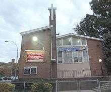
On April 27, 1953, Church of the Open Door, was the first House of God to be built within a New York City Housing project.[37][38]
Infrastructure
Technology
NYCHA is modernizing the Farragut Houses and other NYCHA properties using a program called NextGen NYCHA.[39] There is a MyNYCHA program called "The Digital Van" funded by a Broadband Technology Opportunities Program grant from the United States Department of Commerce; the vans, which are equipped with eight laptops and are available Monday through Friday 10 a.m to 4 p.m., enable residents to use the vans to access the internet.[40] Another app, called the My NYCHA App, allows residents to receive information on service outages, report damages, and request emergency assistance.[41]
Water pipes
The old City of Brooklyn had many water reservoirs. Before the housing project was built, the water was distributed by 36 cast iron main aqueduct pipe to 6-to-8-inch (15 to 20 cm) cast iron branch pipes to the neighborhoods until 1900.[42] The branch pipes replaced 8-to-12-inch (20 to 30 cm) cast iron pipes in the early 1900s.[43][44]
As the population of the neighborhoods kept increasing, the demand for a larger supply of water increased. The increase in population throughout Brooklyn and the soon-to-be other boroughs also caused a problem with the water supply, as the wellwater became polluted and there was an insufficient supply of water.[45] This caused many health problems as there was only a few sources of water. In response, the city began to create a system of water pipes that flowed through the city, as well as outsourced fresh water supplies outside the city.[46] The New York City water system is managed by the Department of Environmental Protection and consists of three upstate aqueducts—the Croton, Catskill, and Delaware aqueducts—the latter two of which flow through Brooklyn.[47]
Farragut Houses currently uses a more modern water pipe system. The New York City Department of Environmental Protection regulates Farragut Houses' water system and its pipes. Each building has its own water piping system and all buildings share three back up water storage tanks in cases of emergencies such as water outages and storms.
Maintenance
NYCHA's job is to create public housing for low income families while also giving them free maintenance, cleaning and heating. Residents of the Farragut Houses have made a large number of complaints and maintenance repair requests, especially during winter. The reason for increased winter complaints is that the outdated buildings are causing problems with piping and heating, causing harsh living conditions for residents. Mayor Bill de Blasio plans to fix these problems.[48]
For instance, on August 16, 2013, the Farragut Houses had 4,034 unanswered repair requests. One of the complainants, a 79-year-old female, stated that she felt unsafe because there is a big hole in her front door, making it impossible to close her door; she had lodged a complaint for four months prior and never got a response. Another resident, who had mold growing in her bathroom, waited two months for a response, and when the NYCHA employee came to fix the problem he came with a mop and a soapy, watery bucket.[49] Paradoxically, De Blasio plans to fix the living conditions of NYCHA homes while also cutting its budget.[50]
Activities
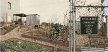
Community Garden
Vinegar Hill Community Garden, located at 199 York Street, Vinegar Hill, Brooklyn. It was built as part of the Gardens for Healthy Communities program in 2013. The 2,500 square foot garden includes 10+ raised beds for growing vegetables, a rainwater harvesting system, shed, and seating. Members of the community and students from the nearby PS 307 Elementary school work in the garden.[51]
See also
References
- ↑ "Farragut Houses Area".
- ↑ "Farragut Houses Population". Archived from the original on 2015-11-16.
- ↑ "MyNYCHA Developments Portal". my.nycha.info. Retrieved 2017-05-08.
- 1 2 Downtown Brooklyn Neighborhood Study. Rep. New York City: Mayor's Committee on Property Improvement, 1941.
- ↑ Wilson, Rufus Rockwell (1902). New York: Old & New: Its Story, Streets, and Landmarks. J. B. Lippincott. p. 354.
- 1 2 "Funds Okayed For Farragut Housing Units". The Brooklyn Daily Eagle. 1 September 1949. p. 1. Retrieved May 6, 2017 – via Newspapers.com.
- ↑ "Civic Center Project Starts to Materialize". the Brooklyn Daily Eagle. 21 March 1945. pp. 1, 11. Retrieved 28 April 2016 – via Newspapers.com.
- ↑ Snyder-Grenier, Ellen M. Brooklyn!: An Illustrated History. Philadelphia: Temple UP, 1996.
- ↑ "First Farragut Tenants Move in Tuesday". The Brooklyn Daily Eagle. 25 March 1951. p. 14. Retrieved May 6, 2017 – via Newspapers.com.
- ↑ "Total population in Census Tract 23". socialexplorer.com.
- ↑ http://www.nyc.gov/html/nypd/downloads/pdf/crime_statistics/cs-en-us-084pct.pdf
- ↑ "'Million-Dollar Blocks' Map Incarceration's Costs". wbur. Retrieved 2015-12-21.
- ↑ "Cameras to go up at tragic Brooklyn housing project, among others | Brooklyn Daily Eagle". www.brooklyneagle.com. Retrieved 2016-04-29.
- 1 2 3 4 5 Williams, Keith (2015-04-17). "Promised a Supermarket Five Years Ago, a Housing Project Is Still Waiting". The New York Times. ISSN 0362-4331. Retrieved 2016-04-29.
- 1 2 "Nabe where thin road divides 2 worlds". NY Daily News. Retrieved 2016-04-29.
- ↑ "Dirty shame: Residents of housing project must walk a half-hour to clean their clothes since city shut down laundry room". The Brooklyn Paper. Retrieved 2016-04-29.
- ↑ "Brooklyn Navy Yard's Wegmans probably won't open until 2018". Curbed NY. 2016-06-21. Retrieved 2017-05-08.
- ↑ "Wegmans set to open first NYC store in Brooklyn". NY Daily News. Retrieved 2017-05-08.
- ↑ "Archived copy". Archived from the original on 2015-11-16. Retrieved 2015-11-23.
- ↑ "Subway Map" (PDF). Metropolitan Transportation Authority. January 18, 2018. Retrieved January 18, 2018.
- ↑ "Announcing the Opening of the Lawrence Street (BMT) Subway Station". Brooklyn Daily Eagle. 11 June 1924. p. 8. Retrieved September 11, 2016.
- ↑ "JOBS ARE ALL FILLED ON SUBWAY LINKS; Board Reports Thousands Already Listed – High St. Station, Brooklyn, Opened" (PDF). The New York Times. June 25, 1933. Retrieved October 27, 2015.
- ↑ "Two Subway Links Start Wednesday". The New York Times. April 6, 1936. p. 23. Retrieved October 7, 2011.
- ↑ "Brooklyn Bus Map" (PDF). Metropolitan Transportation Authority. November 2017. Retrieved April 24, 2018.
- ↑ 1924 BMT Subway-Elevated Map
- ↑ 1937 IND Map
- ↑ 1951 Route Map
- ↑ Team, NYTM Education. "New York Transit Museum - Teacher Resource Center - History of Public Transportation in New York City". Retrieved 7 July 2016.
- ↑ "mta.info - Facts and Figures". Retrieved 7 July 2016.
- ↑ "www.nycsubway.org: Early Rapid Transit in Brooklyn, 1878-1913". Retrieved 7 July 2016.
- ↑ Null(0), Tramway (27 July 2012). "Streetcars and Spatial Analysis: Downtown Brooklyn Streetcar Map 9-22-44 to 3-4-51". Retrieved 7 July 2016.
- ↑ 1951 Route Map, 1951 Route Map (Bottom Half - Brooklyn, lower Manhattan)
- ↑ Venugopal, Nikhita. "PS 307 Begins New School Year After Contentious Rezoning". dnainfo. Dnainfo. Archived from the original on 9 November 2017. Retrieved 8 May 2017.
- ↑ Gill, Lauren. "Controversial Vinegar Hill school rezoning gets passing grade". brookylnpaper. The Brooklyn Paper. Retrieved 8 May 2017.
- ↑ Whitford, Emma. "DUMBO Parents Push Back Against Rezoning That Would Integrate Schools". Gothamist. Archived from the original on 2016-05-07. Retrieved 2016-04-28.
- ↑ "Brooklyn school rezoning proposal at heart of diversity debate is approved". www.capitalnewyork.com. Retrieved 2016-04-29.
- ↑ "Stuck in the middle: Parents won't OK PS 307 rezoning without MS plan". The Brooklyn Paper. Retrieved 2015-12-21.
- ↑ "Clipping from The Brooklyn Daily Eagle on Newspapers.com". Brooklyn Public Library. Retrieved 2015-12-21.
- ↑ "NYCHA - NextGen NYCHA". Retrieved 28 April 2016.
- ↑ "NYCHA - Adults". Retrieved 28 April 2016.
- ↑ "NYCHA - MyNYCHA". Retrieved 28 April 2016.
- ↑ G.M. Hopkins, C.E., F.Bourquin’s Steam Lithographic Press, “Atlas of The City of Brooklyn” Vol.1; 1880; Brooklyn Collection, The Brooklyn Central Public Library.
- ↑ Hugo Ullitz, C.E, E. Belcher Hyde, Inc., “Desk Atlas of the Borough of Brooklyn City of New York” Vol.1; 1903; Brooklyn Collection, The Brooklyn Public Library.
- ↑ E. Robinson C.E, R.H. Pigeon, C.E, E. Belcher Hyde, Inc., “Desk Atlas of the Borough of Brooklyn City of New York” Vol.1; 1920; Brooklyn Collection, The Brooklyn Public Library.
- ↑ "History of Water system". New York City Department of Environmental Protection. Retrieved 2016-04-29.
- ↑ "History of New York City's Water Supply System". New York City Department of Environmental Protection. Retrieved 2016-04-29.
- ↑ "History of New York City's Water Supply System". Retrieved 28 April 2016.
- ↑ "New York City Housing Authority - NYCHA Metrics". Retrieved 7 July 2016.
- ↑ "Vinegar Hill - DUMBO's Farragut Houses Have 4,034 Unanswered Repair Requests, Data Show - Neighborhood News - DNAinfo New York". DNAinfo New York. Archived from the original on 7 August 2016. Retrieved 28 April 2016.
- ↑ "De Blasio Administration Unveils 'NextGeneration NYCHA'". The official website of the City of New York. Retrieved 28 April 2016.
- ↑ "Vinegar Hill Community Garden | GrowNYC". www.grownyc.org. Retrieved 2017-05-10.
- "7 Feb 1954, Page 25 - The Brooklyn Daily Eagle at Newspapers.com". Newspapers.com. Retrieved 2015-12-21.