Flatlands, Brooklyn
Coordinates: 40°37′16″N 73°56′07″W / 40.62111°N 73.93528°W
| New Netherland series |
|---|
| Exploration |
| Fortifications: |
| Settlements: |
| The Patroon System |
|
| People of New Netherland |
| Flushing Remonstrance |
 |
Flatlands is a neighborhood in the southeast part of the borough of Brooklyn in New York City. The area is part of Brooklyn Community Board 18.[1]
Originally an independent town,[2][3] Flatlands became part of the City of Brooklyn in 1896.[4]
The current neighborhood borders are roughly defined by Avenue H to the north, Avenue U to the south, Ralph Avenue to the east, Flatbush Avenue to the southwest and Nostrand Avenue to the northwest.
History
Flatlands was originally known as Nieuw Amersfoort, after the Dutch city of Amersfoort, and was established as a farming community in 1636 when Wolfert Gerritse Van Couwenhoven and Andries Hudde purchased 15,000 acres of land centered on what is now the intersection of Kings Highway and Flatbush Avenue.[5]
Though the area was purchased from Lenape Native Americans[6], there is no definitive evidence that the area was actually inhabited by them, as the notion of land ownership in Lenape culture differed substantially from that of Europeans and they may have been a transient population.
Flatlands was given the right to local rule in 1661 by Peter Stuyvesant as one of the five Dutch Towns on Long Island.
The town’s growth and development came late, largely due to the lack of a transit system or set of roads connecting it with other parts of Brooklyn. The Junction, at Flatbush Avenue and Nostrand Avenue later replaced the town center, and the 2 and 5 trains at Flatbush Avenue station under the Junction made it easier to get to and from Flatlands.[7]
Flatlands was annexed by the city of Brooklyn in 1896.[4]
Land use
Crops typically grown in the area were beans, corn, marsh hay, squash, potato bean and tobacco. Oysters and clams were also farmed and harvested from Jamaica Bay, surrounding marshes and basins. The land-controlling families of Nieuw Amersfoort also kept black slaves to work their farms until the state declared emancipation of all slaves in 1827, after which black laborers took up farming jobs, many times on the farms they worked on as slaves.[7]
Historic buildings
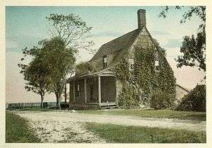
Historic homes dated to the 18th century include the Stoothoff-Baxter-Kouwenhaven House and Joost Van Nuyse House.[8]
Other historic structures are the Hendrick I. Lott House (East 36th Street between Fillmore Ave and Ave. S, built around 1720), which was a stop on the Underground Railroad, and the Flatlands Dutch Reformed Church, founded by Steven Coertse van Voorhees.
Demographics
Based on data from the 2010 United States Census, the population of Flatlands was 64,762, a decrease of 1,964 (2.9%) from the 66,726 counted in 2000. Covering an area of 1,249.32 acres (505.58 ha), the neighborhood had a population density of 51.8 inhabitants per acre (33,200/sq mi; 12,800/km2).[9]
The racial makeup of the neighborhood was 18.2% (11,793) White, 66.3% (42,935) African American, 0.2% (158) Native American, 4.0% (2,577) Asian, 0.0% (16) Pacific Islander, 0.5% (334) from other races, and 1.8% (1,196) from two or more races. Hispanic or Latino of any race were 8.9% (5,753) of the population.[10]
Household income is $75,949,[11] almost $13,000 higher than the average total income for Brooklyn.[12]
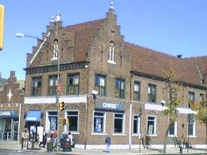
Shopping district
The main shopping streets in Flatlands are Utica Avenue, Flatbush Avenue, Avenue N, and Ralph Avenue. Residents also commonly shop at the nearby indoor mall, Kings Plaza, located by the borders of Flatlands and Marine Park, while being across the water to Mill Basin.
Transportation
No New York City Subway service runs into Flatlands. However, many residents live within walking distance of the IRT Nostrand Avenue Line (2 and 5 trains) which terminates at the junction of Flatbush and Nostrand Avenues; others use buses to get to the BMT Brighton Line (B and Q trains) or the BMT Canarsie Line (L train). Local and express buses are also used as a means of travel in and around the area. As of June 2013, the buses that serve Flatlands are the B2, B3, B6, B7, B9, B41, B44, B44 SBS, B46, B47, B82, B82 SBS, B100, B103, BM1, BM2, Q35.[13]
Notable residents
- Roy DeMeo (1942-1983), Gambino Crime Family member
- Chris Mullin (born 1963), former NBA basketball player, was born and raised in Flatlands.
- Steven Van Voorhees (1600-1684), magistrate, first Voorhees in America
- Abner Louima (born 1966), Haitian immigrant and father, brutally assaulted by NYPD
- Neil Bogart, founder of Casablanca Records, was raised in the Glenwood Houses project in Flatlands.
- Wolfert Gerritse Van Couwenhoven (1579-1662), New Netherland colonist and the original patentee.
References
Notes
- ↑ Brooklyn Community Boards, New York City. Accessed December 31, 2007.
- ↑ 1832-1909., Stiles, Henry Reed, ([2009?]). A history of the city of Brooklyn : including the old towns of Brooklyn, Bushwick, and Williamsburgh. Carlisle, Mass.: Applewood Books. ISBN 1429022221. OCLC 502030985. Check date values in:
|date=(help) - ↑ http://www.davidrumsey.com/luna/servlet/detail/RUMSEY~8~1~25380~1020007:Narrows-Jamaica-Bay,-Brooklyn-?sort=Pub_List_No_InitialSort%2CPub_Date%2CPub_List_No%2CSeries_No&qvq=w4s:/where%2FNew%2BYork%2Fwhen%2F1891;q:Kings%2BCounty;sort:Pub_List_No_InitialSort%2CPub_Date%2CPub_List_No%2CSeries_No;lc:RUMSEY~8~1&mi=6&trs=14
- 1 2 Manbeck, John B. (2008), Brooklyn: Historically Speaking, Charleston, South Carolina: The History Press, ISBN 978-1-59629-500-1 , p.79
- ↑ 1832-1909., Stiles, Henry Reed, ([2009?]). A history of the city of Brooklyn : including the old towns of Brooklyn, Bushwick, and Williamsburgh. Carlisle, Mass.: Applewood Books. ISBN 1429022221. OCLC 502030985. Check date values in:
|date=(help) - ↑ Kilgannon, Corey (2007-11-01). "Dutch Deed Fetches More Than a Handful of Beads". City Room. Retrieved 2018-05-16.
- 1 2 http://brooklynonline.com/history/hubbard.html
- ↑ National Park Service (2009-03-13). "National Register Information System". National Register of Historic Places. National Park Service.
- ↑ Table PL-P5 NTA: Total Population and Persons Per Acre - New York City Neighborhood Tabulation Areas*, 2010, Population Division - New York City Department of City Planning, February 2012. Accessed June 14, 2016.
- ↑ Table PL-P3A NTA: Total Population by Mutually Exclusive Race and Hispanic Origin - New York City Neighborhood Tabulation Areas*, 2010, Population Division - New York City Department of City Planning, March 29, 2011. Accessed June 14, 2016.
- ↑ http://www.point2homes.com/Neighborhood/US/NY/Brooklyn/Flatlands.html
- ↑ http://www.clrsearch.com/Brooklyn_Demographics/NY/
- ↑ "Brooklyn Bus Map" (PDF). Metropolitan Transportation Authority. November 2017. Retrieved April 24, 2018.
Further reading
- New York Times article on Flatlands
- History of Flatlands including early Dutch settlers
- Manbeck, John B. and Jackson, Kenneth T. The Neighborhoods of Brooklyn. New Haven: Yale University Press, 2004. ISBN 0-300-07752-1
- New York City Landmarks Preservation Commission; Dolkart, Andrew S.; Postal, Matthew A. (2009), Postal, Matthew A., ed., Guide to New York City Landmarks (4th ed.), New York: John Wiley & Sons, ISBN 978-0-470-28963-1
External links