SW postcode area
Postcode district boundaries:
| London SW postcode area | |
|---|---|
 SW | |
| Postcode area | SW |
| Postcode area name | London SW |
| Post towns | 1 |
| Postcode districts | 29 |
| Postcode sectors | 139 |
| Postcodes (live) | 21,046 |
| Postcodes (total) | 34,726 |
| Statistics as at February 2012[1] | |
The SW (South Western) postcode area, also known as the London SW postcode area,[2] is a group of postcode districts covering part of southwest London, England. The area originates from the South Western (SW1–SW10) and Battersea (SW11–SW20) districts[3] of the London post town.
Postal administration
The postcode area originated in 1857 as the SW district. In 1868 it gained some of the area of the abolished S district, with the rest going to SE. It was divided into numbered districts in 1917.[4] The South Western district[3] consists of the postcode districts SW1–SW10[3] and the Battersea district[3] consists of the postcode districts SW11–SW20.[5]
List of postcode districts
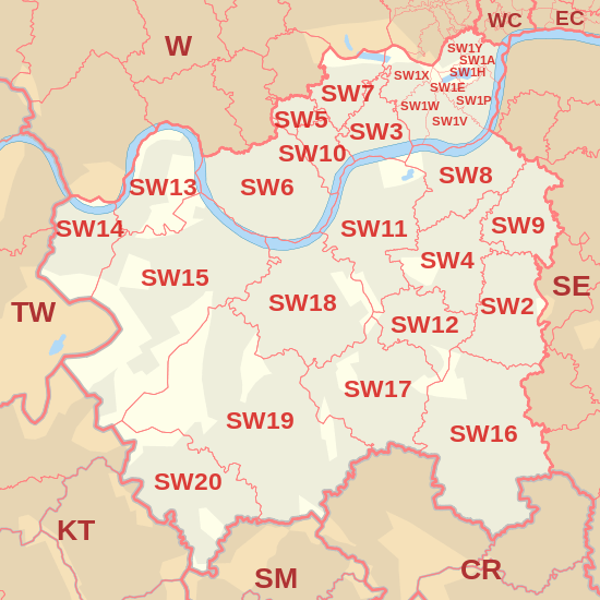
The approximate coverage of the postcode districts, with the historic postal district names shown in italics:[5]
| Postcode district | Post town | Coverage | Local authority area |
|---|---|---|---|
| SW1A | LONDON | Whitehall and Buckingham Palace | Westminster |
| SW1E | LONDON | between Buckingham Gate and Victoria Station | Westminster |
| SW1H | LONDON | east of Buckingham Gate | Westminster |
| SW1P | LONDON | triangular area between Victoria Station, the Houses of Parliament, and Vauxhall Bridge | Westminster |
| SW1V | LONDON | triangular area between Vauxhall Bridge, Chelsea Bridge, and Victoria Station; Pimlico proper | Westminster |
| SW1W | LONDON | Belgravia, Chelsea (part), area between Sloane Square and Victoria Station, south of Kings Road | Kensington and Chelsea, Westminster |
| SW1X | LONDON | Belgravia, north of Eaton Square, Knightsbridge (part), Chelsea (part) | Kensington and Chelsea, Westminster |
| SW1Y | LONDON | St James's | Westminster |
| SW2 | LONDON | Brixton district: Brixton Hill, Tulse Hill (part), Brixton (part), Streatham Hill, Clapham (part), Eastern parts of Balham, Lambeth | Lambeth |
| SW3 | LONDON | Chelsea district: Chelsea, Brompton, Knightsbridge (part) | Kensington and Chelsea |
| SW4 | LONDON | Clapham district: Clapham, Stockwell (part) | Lambeth, Wandsworth |
| SW5 | LONDON | Earls Court district: Earls Court | Kensington and Chelsea |
| SW6 | LONDON | Fulham district: Fulham, Parsons Green | Hammersmith and Fulham |
| SW7 | LONDON | South Kensington district: South Kensington, Knightsbridge (part) | Kensington and Chelsea, Westminster |
| SW8 | LONDON | South Lambeth district: South Lambeth, Wandsworth Road, Vauxhall, Battersea:Nine Elms (part), Clapham (part), NW area of Stockwell, Oval (part) | Lambeth, Wandsworth |
| SW9 | LONDON | Stockwell district: Brixton, Stockwell, Clapham (part), Oval (part) | Lambeth |
| SW10 | LONDON | West Brompton district: West Brompton, Chelsea (west) | Hammersmith and Fulham, Kensington and Chelsea |
| SW11 | LONDON | Battersea head district: Battersea(mostly), Clapham South | Lambeth, Wandsworth |
| SW12 | LONDON | Balham district: Balham, Clapham South, Wandsworth Common (part) | Lambeth, Wandsworth |
| SW13 | LONDON | Barnes district: Barnes, Barnes Bridge | Richmond upon Thames, Hounslow |
| SW14 | LONDON | Mortlake district: Mortlake, East Sheen, Chiswick Bridge | Richmond upon Thames, Hounslow |
| SW15 | LONDON | Putney district: Putney, Roehampton, Kingston Vale, Putney Heath, Putney Vale, Richmond Park, Roehampton Vale | Kingston upon Thames, Richmond upon Thames, Wandsworth |
| SW16 | LONDON | Streatham district: Streatham, Streatham Common, Norbury, Streatham Park, Furzedown, Streatham Vale, Mitcham Common, Pollards Hill, Eastfields | Croydon, Lambeth, Merton, Wandsworth |
| SW17 | LONDON | Tooting district: Tooting, Mitcham (part) Balham (part) | Merton, Wandsworth |
| SW18 | LONDON | Wandsworth district: Wandsworth Town, Southfields, Earlsfield | Wandsworth |
| SW19 | LONDON | Wimbledon district: Wimbledon, Colliers Wood, Merton Park, Merton Abbey, Southfields, Morden (part) | Merton, Wandsworth |
| SW20 | LONDON | West Wimbledon district: Raynes Park, Lower Morden, Merton Park, Wimbledon Chase | Merton |
SW1
SW1 was originally the South Western head district. As it is now of very high density development it has been divided into smaller postcode districts. Where districts are used for purposes other than the sorting of mail, such as use as a geographic reference and on street signs, the SW1 subdivisions continue to be classed as one 'district', SW1 is also officially classed as part of Central London, not South West London due to royal and government purposes. Within the SW1 postcode district there are several distinctive postcode units:
- SW1A 0AA – House of Commons
- SW1A 0PW – House of Lords, Palace of Westminster
- SW1A 1AA – Buckingham Palace
- SW1A 2AA – 10 Downing Street, Prime Minister and First Lord of the Treasury
- SW1A 1BA - Clarence House, Residence and Office of Prince of Wales and Duchess of Cornwall
- SW1A 2AB – 11 Downing Street, Chancellor of the Exchequer
- SW1A 2AH – Foreign and Commonwealth Office, King Charles Street
- SW1A 2HQ – HM Treasury headquarters
Boundaries
The South Western postcode area has nine boroughs including all of the London Borough of Wandsworth, the western portion of the London Borough of Lambeth, a very small part of Royal Borough of Kingston upon Thames, the southern sections of the City of Westminster and the Royal Borough of Kensington and Chelsea, the south-eastern portion of the London Borough of Hammersmith and Fulham, the north-eastern area of the London Borough of Richmond upon Thames, the southern tips of the London Borough of Hounslow's Chiswick District (Barnes Bridge and Chiswick Bridge); and the northern sections of the London Borough of Merton and London Borough of Croydon.[6][7]
Map
See also
References
- ↑ "ONS Postcode Directory Version Notes" (ZIP). National Statistics Postcode Products. Office for National Statistics. February 2012. Table 2. Retrieved 21 April 2012. Coordinates from mean of unit postcode points, "Code-Point Open". OS OpenData. Ordnance Survey. February 2012. Retrieved 21 April 2012.
- ↑ Royal Mail (2004). Address Management Guide (4 ed.). Royal Mail Group.
- 1 2 3 4 Monopolies and Mergers Commission (1980). The Inner London Letter Post. HMSO. Archived from the original on 19 January 2012.
- ↑ "Postcodes" (PDF). Archive Information Sheet. The British Postal Museum and Archive. Archived from the original (PDF) on 20 March 2009. Retrieved 24 March 2010.
- 1 2 "Names of Streets and Places in the London Postal area". HMSO. 1930.
- ↑ File:Londonpostal iln 1857.jpg
- ↑ Postcodes in the United Kingdom#History
External links
- "SW1". The Postcodes Project. Museum of London. Archived from the original on 28 December 2012.
- "SW2". The Postcodes Project. Museum of London. Archived from the original on 27 December 2012.
- "SW3". The Postcodes Project. Museum of London. Archived from the original on 9 November 2012.
- "SW4". The Postcodes Project. Museum of London. Archived from the original on 24 September 2012.
- "SW5". The Postcodes Project. Museum of London. Archived from the original on 24 September 2012.
- "SW6". The Postcodes Project. Museum of London. Archived from the original on 24 September 2012.
- "SW7". The Postcodes Project. Museum of London. Archived from the original on 24 September 2012.
- "SW8". The Postcodes Project. Museum of London. Archived from the original on 20 September 2007.
- "SW9". The Postcodes Project. Museum of London. Archived from the original on 27 November 2012.
- "SW10". The Postcodes Project. Museum of London. Archived from the original on 9 November 2012.
- "SW11". The Postcodes Project. Museum of London. Archived from the original on 28 December 2012.
- "SW12". The Postcodes Project. Museum of London. Archived from the original on 24 September 2012.
- "SW13". The Postcodes Project. Museum of London. Archived from the original on 24 September 2012.
- "SW14". The Postcodes Project. Museum of London. Archived from the original on 20 August 2010.
- "SW15". The Postcodes Project. Museum of London. Archived from the original on 27 November 2012.
- "SW16". The Postcodes Project. Museum of London. Archived from the original on 25 September 2012.
- "SW17". The Postcodes Project. Museum of London. Archived from the original on 20 April 2012.
- "SW18". The Postcodes Project. Museum of London. Archived from the original on 25 September 2012.
- "SW19". The Postcodes Project. Museum of London. Archived from the original on 25 September 2012.
- "SW20". The Postcodes Project. Museum of London. Archived from the original on 25 September 2012.