Local government areas of Western Australia

Map of local government areas in Western Australia

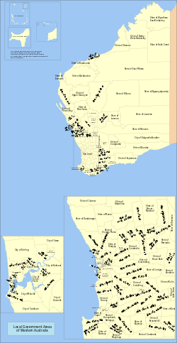
The local government areas (LGAs) in the Australian state of Western Australia describes the 139 institutions and processes by which towns and districts can manage their own affairs to the extent permitted by the Local Government Act 1995.[1] The Local Government Act 1995 also makes provision for regional local governments, established by two or more local governments for a particular purpose.[2]

There are three classifications of local government in Western Australia:

  • City  predominantly urban, some larger regional centres
  • Town  predominantly inner urban, plus Port Hedland
  • Shire  predominantly rural or outer suburban areas

The Shire of Christmas Island and the Shire of Cocos (Keeling) Islands are Federal external territories and covered by the Indian Ocean Territories Administration of Laws Act which allows the Western Australian Local Government Act to apply "on-Island" as though it were a Commonwealth act. Nonetheless, Christmas Island and the Cocos (Keeling) Islands are not part of Western Australia.

Historically, two types of local government existed  municipalities, which represented towns or condensed urban areas, and road districts, which represented all other regions. For instance, the Perth Road District was the precursor to the City of Stirling. Only a few cities  Perth, Fremantle, Subiaco, South Perth and Nedlands  existed prior to 1961. On 1 July 1961, all road districts became shires, and all municipalities became towns.

Metropolitan LGAs

Local government area Council seat[3] Year est. Land area Population
(2015)[4]
Notes
km² sq mi Density
Armadale, City ofArmadale1894560 216 14380,287Armadale-Kelmscott until 1979
Bassendean, Town ofBassendean190110 4 1,61016,101West Guildford until 1922
Bayswater, City ofMorley189733 13 2,13670,472
Belmont, City ofCloverdale189840 15 1,03441,344
Cambridge, Town ofFloreat199422 8 1,28428,250Split from Perth
Canning, City ofCannington190765 25 1,51398,355Placed under control of a Commissioner in 2012
Claremont, Town ofClaremont18985 2 2,14110,706
Cockburn, City ofSpearwood1871168 65 641107,645Fremantle RD until 1959
Cottesloe, Town ofCottesloe18954 2 2,1518,602
East Fremantle, Town ofEast Fremantle18973 1 2,5817,743
Fremantle, City ofFremantle187119 7 1,63431,046
Gosnells, City ofGosnells1907127 49 985125,051
Joondalup, City ofJoondalup199899 38 1,696167,891Split from Wanneroo
Kalamunda, City ofKalamunda1897324 125 18860,830Governed by commissioner until 1961
Kwinana, City ofKwinana Town Centre1954120 46 31037,149
Melville, City ofArdross190053 20 2,012106,655
Mosman Park, Town ofMosman Park18994 2 2,3879,547Split from Peppermint Grove RD. Buckland Hill RD 1899–1908, 1930–1937; Cottesloe Beach RD 1908–1930
Mundaring, Shire ofMundaring1903644 249 6240,015Greenmount until 1932
Nedlands, City ofNedlands189320 8 1,15423,084Claremont RD until 1932
Peppermint Grove, Shire ofPeppermint Grove18951 0 1,6461,646
Perth, City ofPerth185620 8 1,05421,092
Rockingham, City ofRockingham1897257 99 502128,962
Serpentine-Jarrahdale, Shire ofMundijong1894905 349 2321,162
South Perth, City ofSouth Perth189220 8 2,31246,244
Stirling, City ofStirling1871105 41 2,167227,566Shire of Perth until 1971
Subiaco, City ofSubiaco18967 3 2,91820,423
Swan, City ofMidland18711,044 403 128133,303
Victoria Park, Town ofVictoria Park199418 7 2,13638,450Split from Perth
Vincent, City ofLeederville199411 4 3,40637,461Split from Perth
Wanneroo, City ofWanneroo1902686 265 275188,785

Non-metropolitan LGAs

Local government area Council seat[3] Region Year est. Popn.
(2013)[5]
Land area Website Notes
km² sq mi
Albany, City ofAlbanyGreat Southern199836,2624,310.5 1,664albany.wa.gov.auFormerly:
Town of Albany (1871)
Shire of Albany (1871)
Ashburton, Shire ofTom PricePilbara197210,959202,325 78,118ashburton.wa.gov.auWest Pilbara until 1987. Formerly:
Shire of Ashburton (1887)
Shire of Tableland (1896)
Augusta–Margaret River, Shire ofMargaret RiverSouth West189113,1682,123 820amrsc.wa.gov.auAugusta until 1926
Beverley, Shire ofBeverleyWheatbelt18711,5662,372 916beverley.wa.gov.au
Boddington, Shire ofBoddingtonPeel19032,4711,900 734boddington.wa.gov.auMarradong until 1961
Boyup Brook, Shire ofBoyup BrookSouth West18961,7382,827 1,092boyupbrook.wa.gov.auUpper Blackwood until 1969
Bridgetown-Greenbushes, Shire ofBridgetownSouth West19704,5131,340 517bridgetown.wa.gov.auAmalgamation of:
Nelson RD (1887-1917), Bridgetown RD (1917-1961), Shire of Bridgetown (1961-1970);
Greenbushes RD (1900-1961), Shire of Greenbushes (1961-1970)
Brookton, Shire ofBrooktonWheatbelt19069921,602 619brookton.wa.gov.au
Broome, Shire ofBroomeKimberley191817,25154,632 21,094broome.wa.gov.au
Broomehill-Tambellup, Shire ofTambellupGreat Southern20071,1672,610 1,008shirebt.wa.gov.auFormerly:
Shire of Broomehill (1892)
Shire of Tambellup (1905)
Bruce Rock, Shire ofBruce RockWheatbelt19139962,727 1,053brucerock.wa.gov.auEast Avon until 1918
Bunbury, City ofBunburySouth West187133,62365 25bunbury.wa.gov.auCity in 1979
Busselton, City ofBusseltonSouth West195134,2901,455 562busselton.wa.gov.auAmalgamation of Municipality and RD (both 1871)
Capel, Shire ofCapelSouth West189416,447558 215capel.wa.gov.auBunbury RD until 1907
Carnamah, Shire ofCarnamahMid West19235502,876 1,110carnamah.wa.gov.auSplit from Irwin and Mingenew
Carnarvon, Shire ofCarnarvonGascoyne19116,13946,665 18,017carnarvon.wa.gov.auFormerly:
Town of Carnarvon (1891–1965)
Lower Gascoyne RD (1887–1911)
Minilya RD (1893–1911)
Gascoyne-Minilya RD and Shire (1911-1965)
Chapman Valley, Shire ofNabawaMid West19011,2143,988 1,540chapmanvalley.wa.gov.auUpper Chapman until 1958
Chittering, Shire ofBindoonWheatbelt18964,9961,221 471chittering.wa.gov.au
Christmas Island, Shire ofChristmas Island19921462137 53shire.gov.cx

Federal external territory

Cocos, Shire ofHome Island199260514 5shire.cc

Federal external territory

Collie, Shire ofCollieSouth West19519,6921,711 661collie.wa.gov.auAmalgamation of Municipality (1901) and RD (1900)
Coolgardie, Shire ofCoolgardieGoldfields19214,32430,381 11,730coolgardie.wa.gov.auAmalgamation of Municipality (1894) and RD (1896)
Coorow, Shire ofCoorowMid West19621,0854,194 1,619coorow.wa.gov.auSplit from Carnamah
Corrigin, Shire ofCorriginWheatbelt19131,0992,682 1,036corrigin.wa.gov.au
Cranbrook, Shire ofCranbrookGreat Southern19261,1013,278 1,266cranbrook.wa.gov.au
Cuballing, Shire ofCuballingWheatbelt19028781,196 462cuballing.wa.gov.au
Cue, Shire ofCueMid West191229813,607 5,254cue.wa.gov.auAmalgamation of Day Dawn M. (1894) and Cue RD (1895)
Cunderdin, Shire ofCunderdinWheatbelt18941,3021,864 720cunderdin.wa.gov.auSplit from Northam, named Meckering until 1944
Dalwallinu, Shire ofDalwallinuWheatbelt19161,2957,235 2,793dalwallinu.wa.gov.au
Dandaragan, Shire ofJurien BayWheatbelt18903,3256,718 2,594dandaragan.wa.gov.au
Dardanup, Shire ofEatonSouth West189413,791526 203dardanup.wa.gov.au
Denmark, Shire ofDenmarkGreat Southern19115,7481,860 718denmark.wa.gov.au
Derby-West Kimberley, Shire ofDerbyKimberley188410,047119,841 46,271sdwk.wa.gov.auWest Kimberley until 1983
Donnybrook-Balingup, Shire ofDonnybrookSouth West19705,7531,561 603donnybrook-balingup.wa.gov.auFormerly:
Shire of Donnybrook, Preston RD until 1961 (1896)
Shire of Balingup, Upper Capel RD until 1905 (1899)
Dowerin, Shire ofDowerinWheatbelt19116721,865 720dowerin.wa.gov.au
Dumbleyung, Shire ofDumbleyungWheatbelt19096082,542 981dumbleyung.wa.gov.au]
Dundas, Shire ofNorsemanGoldfields19291,18292,656 35,775dundas.wa.gov.au
East Pilbara, Shire ofNewmanPilbara197212,960372,301 143,746eastpilbara.wa.gov.auFormerly:
Shire of Marble Bar (1896)
Shire of Nullagine (1898)
Esperance, Shire ofEsperanceGoldfields189514,24245,059 17,397esperance.wa.gov.auAbsorbed municipality (1895–1908)
Exmouth, Shire ofExmouthGascoyne19642,5706,504 2,511exmouth.wa.gov.au
Gingin, Shire ofGinginWheatbelt18935,2483,211 1,240gingin.wa.gov.auAbsorbed municipality (1893–1903)
Gnowangerup, Shire ofGnowangerupGreat Southern19121,3034,267 1,647gnowangerup.wa.gov.au
Goomalling, Shire ofGoomallingWheatbelt19279761,837 709goomalling.wa.gov.au
Greater Geraldton, City ofGeraldtonMid West201140,4489,903 3,824cgg.wa.gov.auFormerly:
City of Geraldton (1871–2007)
Shire of Greenough (1951–2007)
Shire of Mullewa (1911–2011)
Halls Creek, Shire ofHalls CreekKimberley18873,940133,061 51,375hcshire.wa.gov.auKimberley Goldfields until 1915
Harvey, Shire ofHarveySouth West189425,9241,729 668harvey.wa.gov.au
Irwin, Shire ofDongaraMid West18713,7802,375 917irwin.wa.gov.au
Jerramungup, Shire ofJerramungupGreat Southern19821,0856,509 2,513jerramungup.wa.gov.auSplit from Gnowangerup
Kalgoorlie-Boulder, City ofKalgoorlieGoldfields198933,76395,242 36,773kalbould.wa.gov.auFormerly:
Town of Kalgoorlie (1897–1989)
Shire of Boulder (1969–1989)
Karratha, City ofKarrathaPilbara188725,90715,278 5,899karratha.wa.gov.auAbsorbed Roebourne and Cossack municipalities in 1910, was known as Shire of Roebourne until 2014
Katanning, Shire ofKatanningGreat Southern18924,4071,519 586katanning.wa.gov.au
Kellerberrin, Shire ofKellerberrinWheatbelt19081,2271,917 740kellerberrin.wa.gov.au
Kent, Shire ofNyabingGreat Southern19225285,631 2,174kent.wa.gov.auNyabing-Pingrup 1955–1972
Kojonup, Shire ofKojonupGreat Southern18712,0222,932 1,132kojonup.wa.gov.au
Kondinin, Shire ofKondininWheatbelt19251,0427,427 2,868kondinin.wa.gov.au
Koorda, Shire ofKoordaWheatbelt19274312,835 1,095koorda.wa.gov.au
Kulin, Shire ofKulinWheatbelt19188344,720 1,822kulin.wa.gov.auRoe until 1926
Lake Grace, Shire ofLake GraceWheatbelt19221,37011,892 4,592lakegrace.wa.gov.au
Laverton, Shire ofLavertonGoldfields19061,357180,127 69,547laverton.wa.gov.auMount Margaret until 1950, absorbed Mount Morgans M (1900–1913)
Leonora, Shire ofLeonoraGoldfields19122,76431,941 12,332leonora.wa.gov.au
Mandurah, City ofMandurahPeel194980,683174 67mandurah.wa.gov.auCity in 1990
Manjimup, Shire ofManjimupSouth West19089,4277,027 2,713manjimup.wa.gov.auWarren until 1925
Meekatharra, Shire ofMeekatharraMid West19091,521100,327 38,736meekashire.wa.gov.au
Menzies, Shire ofMenziesGoldfields1912422124,794 48,183menzies.wa.gov.au
Merredin, Shire ofMerredinWheatbelt19213,3003,297 1,273merredin.wa.gov.au
Mingenew, Shire ofMingenewMid West19014861,937 748mingenew.wa.gov.auUpper Irwin until 1919
Moora, Shire ofMooraWheatbelt19082,5353,767 1,454moora.wa.gov.auSplit from Victoria Plains
Morawa, Shire ofMorawaMid West19289063,517 1,358morawa.wa.gov.auSplit from Perenjori-Morawa RD
Mount Magnet, Shire ofMount MagnetMid West190171113,893 5,364mtmagnet.wa.gov.auAbsorbed municipality (1896–1901)
Mount Marshall, Shire ofBencubbinWheatbelt192347110,197 3,937mtmarshall.wa.gov.au
Mukinbudin, Shire ofMukinbudinWheatbelt19334913,438 1,327mukinbudin.wa.gov.au
Murchison, Shire ofMurchisonMid West187512745,110 17,417murchison.wa.gov.au
Murray, Shire ofPinjarraPeel188716,3041,711 661murray.wa.gov.au
Nannup, Shire ofNannupSouth West18901,3163,055 1,180nannup.wa.gov.auLower Blackwood until 1925
Narembeen, Shire ofNarembeenWheatbelt19258103,836 1,481narembeen.wa.gov.au
Narrogin, Shire ofNarroginWheatbelt18925,3141,632 630narrogin.wa.gov.auAbsorbed Town of Narrogin (1906–2016)
Ngaanyatjarraku, Shire ofWarburtonGoldfields1,543160,733 62,059ngaanyatjarraku.wa.gov.au
Northam, Shire ofNorthamWheatbelt187111,7301,432 553northam.wa.gov.auAbsorbed Town of Northam (1879–2007)
Northampton, Shire ofNorthamptonMid West18713,37912,638 4,880northampton.wa.gov.auMines RD until 1887
Nungarin, Shire ofNungarinWheatbelt19212281,164 449nungarin.wa.gov.au
Perenjori, Shire ofPerenjoriMid West19169248,311 3,209perenjori.wa.gov.auPerenjori-Morawa until 1928
Pingelly, Shire ofPingellyWheatbelt18911,1951,295 500pingelly.wa.gov.auMoorumbine until 1913
Plantagenet, Shire ofMount BarkerGreat Southern18715,1824,877 1,883plantagenet.wa.gov.au
Port Hedland, Town ofPort HedlandPilbara189116,47218,482 7,136porthedland.wa.gov.auPilbara until 1904. Town 1989
Quairading, Shire ofQuairadingWheatbelt19131,0942,018 779quairading.wa.gov.auAvon until 1922
Ravensthorpe, Shire ofRavensthorpeGoldfields19002,2889,833 3,797ravensthorpe.wa.gov.auPhillips River until 1961
Sandstone, Shire ofSandstoneMid West189711632,714 12,631sandstone.wa.gov.auBlack Range until 1961
Shark Bay, Shire ofDenhamGascoyne190492824,184 9,337sharkbay.wa.gov.au
Tammin, Shire ofTamminWheatbelt19484011,103 426tammin.wa.gov.auSplit from Cunderdin
Three Springs, Shire ofThree SpringsMid West19286322,656 1,025threesprings.wa.gov.au
Toodyay, Shire ofToodyayWheatbelt19124,8861,693 654toodyay.wa.gov.auAmalgamation of Newcastle M (1877) and Toodyay RD (1871)
Trayning, Shire ofTrayningWheatbelt19113421,652 638trayning.wa.gov.au
Upper Gascoyne, Shire ofGascoyne JunctionGascoyne188726258,007 22,397uppergascoyne.wa.gov.au
Victoria Plains, Shire ofCalingiriWheatbelt18719212,553 986victoriaplains.wa.gov.au
Wagin, Shire ofWaginWheatbelt18871,9751,947 752wagin.wa.gov.auArthur until 1905. Absorbed municipality (1906–1961)
Wandering, Shire ofWanderingWheatbelt18744381,901 734wandering.wa.gov.au
Waroona, Shire ofWaroonaPeel18983,843832 321waroona.wa.gov.auDrakesbrook until 1961
West Arthur, Shire ofDarkanWheatbelt18968872,834 1,094westarthur.wa.gov.au
Westonia, Shire ofWestoniaWheatbelt19162723,316 1,280westonia.wa.gov.au
Wickepin, Shire ofWickepinWheatbelt19097502,041 788wickepin.wa.gov.au
Williams, Shire ofWilliamsWheatbelt18719282,306 890williams.wa.gov.au
Wiluna, Shire ofWilunaMid West19091,279181,662 70,140wiluna.wa.gov.au
Wongan-Ballidu, Shire ofWongan HillsWheatbelt18871,5863,368 1,300wongan.wa.gov.auMelbourne until 1926
Woodanilling, Shire ofWoodanillingGreat Southern19064291,129 436woodanilling.wa.gov.au
Wyalkatchem, Shire ofWyalkatchemWheatbelt19205191,596 616wyalkatchem.wa.gov.au
Wyndham East Kimberley, Shire ofKununurraKimberley18878,652112,023 43,252swek.wa.gov.auEast Kimberley until 1896, Wyndham until 1961
Yalgoo, Shire ofYalgooMid West190744527,976 10,802yalgoo.wa.gov.auUpper Murchison until 1912
Yilgarn, Shire ofSouthern CrossWheatbelt18911,69830,405 11,739yilgarn.wa.gov.auAbsorbed Southern Cross M (1892–1918)
York, Shire ofYorkWheatbelt18713,5812,133 824york.wa.gov.auAbsorbed Town of York (1871–1965)

Regional local government organisations

References

  1. "Local Government Act 1995". Retrieved 26 July 2011.
  2. Refer Part 3 Division 4 of the "Local Government Act 1995". Retrieved 26 July 2011.
  3. 1 2 Department of Health. "Local Government contacts". Retrieved 26 July 2009.
  4. "3218.0 – Regional Population Growth, Australia, 2014–15". Australian Bureau of Statistics. Retrieved 29 September 2016.
  5. Australian Bureau of Statistics (3 April 2014). "Regional Population Growth, Australia, 2009–10 – Western Australia". Retrieved 13 June 2014.
  6. "Bunbury Harvey Regional Council". Retrieved 19 April 2016.
  7. "Eastern Metropolitan Regional Council". Retrieved 19 April 2016.
  8. "Mindarie Regional Council". Retrieved 19 April 2016.
  9. "Murchison Regional Vermin Council". Retrieved 3 August 2017.
  10. "Pilbara Regional Council". Retrieved 19 April 2016.
  11. "Rivers Regional Council". Retrieved 19 April 2016.
  12. "Southern Metropolitan Regional Council". Retrieved 19 April 2016.
  13. "Tamala Park Regional Council". Retrieved 19 April 2016.
  14. "Western Metropolitan Regional Council". Retrieved 19 April 2016.
  • "Shires of Australia". Statoids.
This article is issued from Wikipedia. The text is licensed under Creative Commons - Attribution - Sharealike. Additional terms may apply for the media files.