City of Kalgoorlie-Boulder
| City of Kalgoorlie-Boulder Western Australia | |||||||||||||||
|---|---|---|---|---|---|---|---|---|---|---|---|---|---|---|---|
 Location in Western Australia | |||||||||||||||
| Population | 30,059 (2016 census)[1] | ||||||||||||||
| • Density | 0.314507/km2 (0.814568/sq mi) | ||||||||||||||
| Established | 1989 | ||||||||||||||
| Area | 95,575.1 km2 (36,901.8 sq mi) | ||||||||||||||
| Mayor | John Bowler | ||||||||||||||
| Council seat | Kalgoorlie | ||||||||||||||
| Region | Goldfields-Esperance | ||||||||||||||
| State electorate(s) | Kalgoorlie | ||||||||||||||
| Federal Division(s) | O'Connor | ||||||||||||||
|
| |||||||||||||||
| Website | City of Kalgoorlie-Boulder | ||||||||||||||
| |||||||||||||||
The City of Kalgoorlie-Boulder is a local government area in the Goldfields-Esperance region of Western Australia, about 550 kilometres (342 mi) east of the state capital, Perth. The City covers an area of 95,575 square kilometres (36,902 sq mi), and its seat of government is the town of Kalgoorlie; all but 244 of the city's population live in either Kalgoorlie or Boulder.
History
This region has a long history of continuous inhabitation and cultivation by Aboriginal Australians.
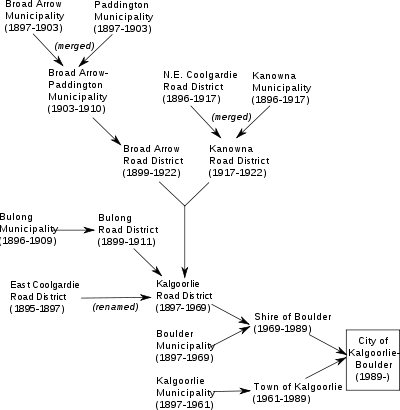
In the years immediately after discovery of gold in the region, a variety of local government entities sprang up around the often-temporary settlements on the Kalgoorlie goldfields. Only three persisted beyond the early 20th century:
- Boulder Municipal Council (1897–1961)[2] – later Town of Boulder (1961–1969) and Shire of Boulder (1961-1989)
- Kalgoorlie Roads Board (1896–1961) – later Shire of Kalgoorlie (1961–1969)[3]
- Kalgoorlie Municipal Council (1895–1961)[4] – later Town of Kalgoorlie (1961–1989)[5]
The others were:
- Broad Arrow Municipal Council (1897–1903)[6]
- Broad Arrow Roads Board (1899–1922)[7]
- Broad Arrow-Paddington Municipal Council (1903–1910)[8]
- Bulong Municipal Council (1896–1909)[9]
- Bulong Roads Board (1899–1911)[10]
- East Coolgardie Roads Board (1895–1897)[11]
- Kanowna Municipal Council (1896–1917)[12]
- North East Coolgardie Roads Board (1896–1922)[13]
- Paddington Municipal Council (1901–1903)
Roads in Kalgoorlie-Boulder
- Boulder Road
- Anzac Drive
- Gatacre Drive
- Picadilly Street
- Hannan Street
- Graeme Street
- Maritana Street
- Federal Road
Major Roads in the region
Origins of the City
Key dates
- 1 July 1961 – Boulder and Kalgoorlie municipalities became towns, and Kalgoorlie Roads Board became a shire, following changes to the Local Government Act
- 1 July 1969 – Town of Boulder was amalgamated into the Shire of Kalgoorlie, which was renamed Shire of Boulder.
- 1 February 1989 – The Shire of Boulder and Town of Kalgoorlie amalgamated to form the City of Kalgoorlie-Boulder.[14]
Wards
The City is not divided into wards and the twelve councillors sit at large. The mayor is elected by popular vote.
Suburbs
- Kalgoorlie
- Boulder
- Binduli
- Broadwood
- Brown Hill
- Fimiston
- Hannans
- Karlkurla
- Lamington
- Mullingar
- Parkeston
- Piccadilly
- Somerville
- South Boulder
- South Kalgoorlie
- Trafalgar
- Victory Heights
- West Kalgoorlie
- West Lamington
- Williamstown
- Yilkari
Towns
References
- ↑ Australian Bureau of Statistics (27 June 2017). "Kalgoorlie/Boulder (C)". 2016 Census QuickStats. Retrieved 26 November 2017.

- ↑ "BOULDER MUNICIPAL COUNCIL". Kalgoorlie Western Argus. XIX, (964). Western Australia. 6 May 1913. p. 10. Retrieved 30 April 2017 – via National Library of Australia.
- ↑ Boulder (W.A. : Municipality). Council; Kalgoorlie (W.A. : Municipality). Council; Kalgoorlie (W.A. : Municipality). Road Board; Conference of Goldfields Local Bodies (W.A.) (1919), Eastern goldfields tourists' guide containing information concerning the chief places of interest in the district, and the various business houses, The Conference, retrieved 30 April 2017
- ↑ "KALGOORLIE MUNICIPAL COUNCIL". Western Argus. 24, (5191). Western Australia. 22 May 1923. p. 7. Retrieved 30 April 2017 – via National Library of Australia.
- ↑ Spencer Compton, George (1965), 1895-1965, seventy years : the beginnings of the town of Kalgoorlie, The author, retrieved 30 April 2017
- ↑ "Broad Arrow Municipal Council". Kalgoorlie Miner. 5, (1292). Western Australia. 1 February 1900. p. 4. Retrieved 30 April 2017 – via National Library of Australia.
- ↑ "BROAD ARROW ROADS BOARD". Kalgoorlie Western Argus. XII, (588). Western Australia. 27 March 1906. p. 14. Retrieved 30 April 2017 – via National Library of Australia.
- ↑ "BROAD ARROW-PADDINGTON". Kalgoorlie Western Argus. IX, (466). Western Australia. 24 November 1903. p. 12. Retrieved 30 April 2017 – via National Library of Australia.
- ↑ "BULONG MUNICIPAL COUNCIL". Kalgoorlie Miner. 8, (18699). Western Australia. 20 February 1903. p. 2. Retrieved 30 April 2017 – via National Library of Australia.
- ↑ "BULONG ROADS BOARD". Kalgoorlie Miner. 8, (18666). Western Australia. 15 January 1903. p. 2. Retrieved 30 April 2017 – via National Library of Australia.
- ↑ "East Coolgardie Roads Board". Kalgoorlie Miner. II, (499). Western Australia. 14 May 1897. p. 2. Retrieved 30 April 2017 – via National Library of Australia.
- ↑ "KANOWNA". Kalgoorlie Western Argus. 2, (79). Western Australia. 28 May 1896. p. 7. Retrieved 30 April 2017 – via National Library of Australia.
- ↑ "NORTH-EAST COOLGARDIE ROADS BOARD". Kalgoorlie Miner. 19, (4537). Western Australia. 7 July 1913. p. 2. Retrieved 30 April 2017 – via National Library of Australia.
- ↑ WA Electoral Commission, Municipality Boundary Amendments Register (release 2.0), 31 May 2003.